
Watermelon Peak is a 3,095-metre (10,154-foot) summit located in Banff National Park, in the Canadian Rockies of Alberta, Canada. Its nearest higher peak is Deluc Peak, 13.5 km (8.4 mi) to the east.

Avalanche Mountain is a 2,861-metre (9,386-foot) summit in Glacier National Park in the Selkirk Mountains in British Columbia, Canada. Its nearest higher peak is Mount Macdonald, 2.2 km (1.4 mi) to the north. Mount Sir Donald is 3.83 km (2.38 mi) to the southeast, and Eagle Peak is 1.46 km (0.91 mi) to the south-southeast. The Avalanche Glacier is situated on the east side of the peak, and the Connaught Tunnel lies partially beneath Avalanche Mountain. The peak is visible from eastbound Highway 1, the Trans-Canada Highway approaching Rogers Pass. During winter and spring of each year the western slope, named Avalanche Crest, generates avalanches which can threaten the highway.

Trolltinder Mountain is a 2,912-metre (9,554-foot) mountain summit located immediately west of the Continental Divide, in the Waputik Range of the Canadian Rockies in British Columbia, Canada. It is situated in Yoho National Park, with its nearest higher peak being Mount Balfour, 1.0 km (0.62 mi) to the northeast, and Fairy Lake directly below its southern slope.

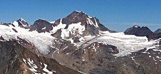
Mount Geikie, pronounced like "geeky", is a 3,298-metre (10,820-foot) mountain summit located in Mount Robson Provincial Park in British Columbia, Canada. Situated 28 km (17 mi) southwest of Jasper near the Tonquin Valley, Mount Geikie is the highest peak of The Ramparts in the Canadian Rockies, one of the most beautiful mountain meccas in the world. Its nearest higher peak is Mount Fraser, 8.0 km (5.0 mi) to the southeast, and the Continental Divide lies 3.0 km (1.9 mi) to the east. Mount Geikie is composed of quartzite of the Cambrian period. This rock was pushed east and over the top of younger rock during the Laramide orogeny. The vertical wall of its north face is over 1,500-metre (4,900-foot) high, and has been compared to the other great north faces of the Canadian Rockies such as North Twin, Alberta, and Kitchener.

Gimli Peak is a 2,806-metre (9,206 ft) mountain summit located in the Valhalla Ranges of the Selkirk Mountains in British Columbia, Canada. Gimli Peak is the fourth-highest point in the Valhalla Ranges, with the highest being Gladsheim Peak, 2.7 km (1.7 mi) to the north. Its nearest higher peak is Midgard Peak, 1.8 km (1.1 mi) to the northwest. It is situated in southern Valhalla Provincial Park, immediately southwest of Mulvey Lakes, and 12 km (7.5 mi) west of Slocan and Slocan Lake. The name "Valhalla Mountains" first appeared in George Mercer Dawson's Geological Survey of Canada map published in 1890. Dawson applied names derived from Scandinavian mythology to several of the mountain ranges and peaks in Southern Kootenay. In keeping with the Valhalla theme, this peak was originally labelled "Mount Gimli" on a 1900 Geological Survey of Canada publication, and it was officially adopted April 29, 1998, by the Geographical Names Board of Canada as Gimli Peak. According to Norse mythology, Gimli is the place where the righteous survivors of Ragnarök are foretold to live. Based on the Köppen climate classification, Gimli Peak has a subarctic climate with cold, snowy winters, and mild summers. Winter temperatures can drop below −20 °C with wind chill factors below −30 °C. Precipitation runoff from the mountain drains into tributaries of the Slocan River.
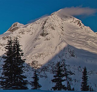
Eyebrow Peak is a prominent 3,362-metre (11,030-foot) glaciated mountain summit located in the Purcell Mountains in southeast British Columbia, Canada. It is the ninth-highest peak in the Purcells. It is situated 28 km (17 mi) south of The Bugaboos, 44 km (27 mi) west of Invermere, 6 km (3.7 mi) north of Mount Monica, and 18 km (11 mi) east of Duncan Lake. Its nearest higher peak is Commander Mountain, 11.4 km (7.1 mi) to the southeast. The first ascent of the mountain was made in 1914 by Edward Warren Harnden, D. Brown, L. Nettleton, and E. Parson via the west slopes. The name Eyebrow Peak came about by Arthur Oliver Wheeler in 1910 when viewing two broad rock scars near the summit, and their arrangement in connection with the surrounding snow created the appearance of enormous eyebrows. However, using the same sightings as Wheeler, Professor Peter Robinson showed that Wheeler actually saw Mount Farnham. Poor weather conditions led to Wheeler's error, and the Eyebrow moniker was then moved to its present location. The mountain's name was officially adopted June 9, 1960, by the Geographical Names Board of Canada.
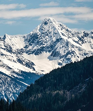
Jumbo Mountain, sometimes called Mount Jumbo, is a 3,437-metre-elevation (11,276-foot) mountain summit located 42 km (26 mi) west-southwest of Invermere in the Purcell Mountains of southeast British Columbia, Canada. The nearest higher peak is Mount Farnham, 11 km (6.8 mi) to the north-northeast, and Karnak Mountain is set 0.79 km (0.49 mi) to the west. Jumbo and Karnak form a double summit massif which is the second-highest mountain in the Purcells, and fourth-highest in the Columbia Mountains. The first ascent of Jumbo Mountain was made August 4, 1915, by H.O. Frind, A.H. & E.L. MacCarthy, M & W.E. Stone, B. Shultz, and Conrad Kain via the North/Northeast Slopes. March 5, 1919, Conrad made a solo ascent of Jumbo Mtn on snowshoes - credited as the first winter ascent of an 11,000-ft peak in Canada. The peak was named by Edward Warren Harnden after the 1892 Jumbo Mineral Claim on nearby Toby Creek, which in turn was named for Jumbo the elephant. The mountain's toponym was officially adopted March 31, 1924, when approved by the Geographical Names Board of Canada.

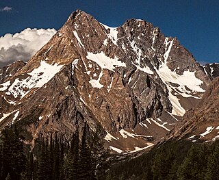
Commander Mountain is a 3,371-metre (11,060 ft) glaciated mountain summit located 42 km (26 mi) west-southwest of Invermere in the Purcell Mountains of southeast British Columbia, Canada. It is the seventh-highest mountain in the Purcells. The nearest higher peak is Jumbo Mountain, 2 km (1.2 mi) to the south, and The Lieutenants is set 2.12 km (1.32 mi) to the west.

Deluge Mountain is a mountain summit located in British Columbia, Canada.

Taurus Mountain is a mountain summit located in British Columbia, Canada.

Mount Head is a 2,782-metre (9,127-foot) mountain summit located in Alberta, Canada.
Albert Peak is a 3,045-metre (9,990-foot) mountain summit located in British Columbia, Canada.

Downie Peak is a 2,926-metre (9,600 ft) mountain summit located in British Columbia, Canada.
Mount Conrad is a 3,279-metre (10,758-foot) mountain summit in British Columbia, Canada.

The Four Squatters is a 3,072-metre (10,079-foot) mountain in British Columbia, Canada.
Mount Butters is a 3,141-metre (10,305-foot) mountain summit in British Columbia, Canada.

Mount Proteus is a 3,198-metre (10,492-foot) mountain summit in British Columbia, Canada.
Pequod Mountain is a 2,979-metre (9,774-foot) summit in British Columbia, Canada.
Moby Dick Mountain is a 3,154-metre (10,348-foot) summit in British Columbia, Canada.

Wallace Peak is a 2,940-metre (9,650-foot) summit in British Columbia, Canada.


