Hanamasagar

Last updated

Hanamasagar
Halasagar
Village
India Karnataka location map.svg
Red pog.svg
Hanamasagar
Location in Karnataka, India
India location map.svg
Red pog.svg
Hanamasagar
Hanamasagar (India)
Coordinates: 16°35′N75°41′E / 16.59°N 75.68°E / 16.59; 75.68
CountryFlag of India.svg  India
State Karnataka
District Vijayapur district, Karnataka
Taluka Vijayapur Taluka
Population
 (2011)
  Total1,435
Languages
  Official Kannada
Time zone UTC+5:30 (IST)
Vehicle registration KA-28
Nearest city Vijayapur, Karnataka
Sex ratio 966
Literacy66.37%
Lok Sabha constituency Vijayapur

Hanamasagar (Halasagar) is a village in the southern state of Karnataka, India. It is located in Vijayapur taluk, of Vijayapur district, Karnataka and is nearly 40km from the district headquarter Vijayapur. It is a small village which is a pilgrim, having the post office at Kambagi and Babaleshwar hobli.

Contents

Shree Shivayya Swamiji, Babaladi-Chamakeri Shree Vedamurty Shivayya Mahaswamiji.jpg
Shree Shivayya Swamiji, Babaladi-Chamakeri

History

Hanamasagar was a pilgrim on behalf of Shree Karigirishwar Swamiji who was there in the last century. Only one photo of Swamiji is available which is featured on the emblem. Every year in the month of July there is a festival. Shree Guru Chakravarti Sadashiv Murthy (Muthya) of Babaladi has a matt in Hanamasagar, i.e., Shri Karigiri Sangam Shivalingeshwar Punyashram (ಶ್ರೀ ಕರಿಗಿರಿ ಸಂಗಮ ಶಿವಲಿಂಗೇಶ್ವರ ಪುಣ್ಯಾಶ್ರಮ,ಸುಕ್ಷೇತ್ರ ಹಣಮಸಾಗರ). and shri Sangameshwar utasava in sravan massa.

Demographics

As of the 2011 Indian Census , Hanumasagar is a medium size village located in Bijapur Taluka of Bijapur district, Karnataka with a total of 242 families residing. The Hanumasagar village has a population of 1435, of which 730 are males and 705 are females according to the 2011 Census.

In Hanumasagar village population of children with age 0-6 is 201 which makes up 14.01% of total population of village. Average Sex Ratio of Hanumasagar village is 966 which is lower than Karnataka state average of 973. Child Sex Ratio for the Hanumasagar as per census is 1209, higher than Karnataka average of 948.

Hanumasagar village has lower literacy rate compared to Karnataka. In 2011, literacy rate of Hanumasagar village was 66.37% compared to 75.36% of Karnataka. In Hanumasagar Male literacy stands at 76.37% while female literacy rate was 55.63%. [1]

Geography

The village is situated geographically at 16°32'11.5"N north latitude and 75°31'16.7"E east longitude.

Agriculture

The village mainly grows sugarcane, grapes, pomegranates, maize, and sorghum (jawar), as well as small area of lemon, onion, and turmeric etc. Irrigation via water canals, bore-wells and open wells.

Religion

The village mainly houses Hindu and Muslim people.

Language

People can speak mainly Kannada also Hindi, Marathi, Urdu and English as well.

Temples

The village has several temples, Such as:

Mosques

Khaza Bande Nawaz Mosque and Maszid for Muslim community. Moharam and Uras festivals are celebrated by both Hindu and Muslim religion.

Festivals

Annual festivals are celebrating in village, such as Shri Shivalingeshwar Paramarthikotsava, Shri Hari Pandurang Vittal Saptaha (Dindhi), Shree Sangameshwar Festival, Khaza Bandenawaz Uras, as well as Kara Hunnume, Nagara Panchami, Deepavli, Ugadi, and Dassara etc.

Education

Village has a Govt Higher Primary School (HPS) currently working with 1st to 8th standard and having more than 150 students.

Literacy Rate

The village literacy rate is about 66.37%. Males has 76.37% and Female has 55.63% of literacy.

Politics

Hanamasagar village comes under Babaleshwar Assembly Constituency and Vijayapur Parliamentary Constituency. Mahadevappa Balappa Madarakhandi were ex-member of Vijayapur Taluk Panchayat.

PIN Code

Post office is in Kambagi and head Post office is in Sarawad.

Transportation

State highway 55 passes over Hanamasagar. The village is well connected to district headquarter Vijayapur via Kambagi through Babaleshwar.

Climate and Temperature

Climate data for Hanamasagar
MonthJanFebMarAprMayJunJulAugSepOctNovDecYear
Average high °C (°F)29.2
(84.6)
32.8
(91.0)
35.9
(96.6)
37.9
(100.2)
37.5
(99.5)
34.0
(93.2)
31.1
(88.0)
31.0
(87.8)
31.1
(88.0)
31.0
(87.8)
29.5
(85.1)
29.0
(84.2)
32.5
(90.5)
Average low °C (°F)15.5
(59.9)
17.6
(63.7)
22.6
(72.7)
24.0
(75.2)
25.0
(77.0)
23.0
(73.4)
22.2
(72.0)
22.0
(71.6)
22.7
(72.9)
20.2
(68.4)
16.7
(62.1)
13.0
(55.4)
20.4
(68.7)
Average rainfall mm (inches)8.6
(0.34)
3.1
(0.12)
6.0
(0.24)
10.0
(0.39)
16.2
(0.64)
61.1
(2.41)
77.1
(3.04)
74.5
(2.93)
62.0
(2.44)
51.6
(2.03)
27.2
(1.07)
3.5
(0.14)
400.9
(15.79)
[ citation needed ]

Village has a semi-arid climate. It has an average elevation of 606metres (1988ft).

The climate is generally dry and healthy. In summer, especially in April and May it is too hot; at that time the temperature lays between 40 degree Celsius to 42 degree Celsius. In winter season, from November to January the temperature is between 20 degree Celsius to 30 degree Celsius. Usually the district has dry weather, so the humidity varies from 10% to 30%.

Related Research Articles

<span class="mw-page-title-main">Shahapur, Karnataka</span> Town in Karnataka, India

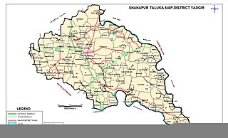
Shahapur is a city and taluka headquarter located in the Yadgir district of Indian state of Karnataka. Shahapur is 597 km north of Bangalore and well connected by road to Gulbarga (70 km), Hyderabad (240 km), Bidar (160 km), Raichur (90 km) and Yadgir (32 km).

Kaladgi is a panchayat village in the Bagalkot Taluk, Bagalkot District of Karnataka State and is located about 25 km by road west of the town of Bagalkot. Kaladgi is well known for its fruit gardens.

<span class="mw-page-title-main">Lingasugur</span> Town in Karnataka, India

Lingasugur is a municipal town in Raichur district in the Indian state of Karnataka. There are many Temples, hills and forts (Quila). The festivals of Muharram and Maha Shivaratri are important here. Mudgal in Lingasugur taluk has a very ancient fort. It has often been mentioned in the autobiography of Philip Meadows Taylor. Lingasugur, then known as Chavani was the site of a major British cantonment in the region.

Sindagi is a City and Taluk in Vijayapura district in the Indian state of Karnataka, about 60 km to the east of Bijapur.

Basavana Bagewadi is a municipality and taluka in Bijapur district in the state of Karnataka, India.

Indi is a city in the state of Karnataka, India. It is the taluk headquarters of Indi Taluk, in the district of Vijayapura.

<span class="mw-page-title-main">Athani, Belagavi</span> Town in Karnataka, India

Athani is a town in the Belagavi district of Karnataka, India. It is 140 kilometers from the city of Belagavi, 70 kilometers from Vijayapura, 55 kilometers from Miraj, 100 kilometers from Kolhapur, and 624 kilometers from Bengaluru.

Bijjaragi is a village in the State of Karnataka, India. It is located in Vijayapur taluk of Vijayapur district, Karnataka.

Huvina Hipparagi also Huvin Hipparagi is a Town in the southern state of Karnataka, India. It is located in the Basavana Bagevadi taluk of Vijayapura district in Karnataka.

Tikota is a taluka in the southern state of Karnataka, India. It is located in the Bijapur District.

Chamakeri is a village in the Belgaum district of Athani Taluk in the southern Indian state of Karnataka.

Gunadal is a panchayat village in the state of Karnataka, India. Administratively it is under Bijapur Taluka of Bijapur district, Karnataka. Located in the far southwestern corner of the district, Gunadal is nearly 45 km by road from the district headquarters, the city of Bijapur. In Gunadal there is a Government Ayurvedic Hospital, Government Veterinary Hospital, Post Office, Police Station and gram panchayat headquarters.

Kambagi is a panchayat village in the southern state of Karnataka, India. Administratively it is under Vijayapur Taluk of Vijayapur District, Karnataka. It is nearly 40 kilometres (25 mi) from district headquarters, the city of Vijayapur, Karnataka. Kambagi has Government Primary HealthCare Center, Post Office, Bank of India and Gram Panchayat offices.

Babalad or Muttyna Babalad is a village in the southern state of Karnataka, India. It is located in Bijapur taluk of Bijapur district, Karnataka. It is nearly 25 km from the district headquarters, Bijapur. It's one of several small villages near Bijapur.

Yaragalla is a village in the southern state of Karnataka, India.

Katakanahalli or Katnalli is a village in the southern state of Karnataka, India. It is located in Bijapur taluk of the Bijapur district, Karnataka, and nearly 15 kilometers (km) from the district headquarters, Bijapur. It's one of the small villages near Bijapur.

Zalaki is a village in the southern state of Karnataka, India. It is located in the Chadachan Taluk of Vijayapur district, Karnataka.

Bijapur Taluk, officially Vijayapura Taluka, is a taluka in the Indian state of Karnataka. It is located in the Bijapur district. The administrative centre for Bijapur Taluka is in the city of Bijapur. The taluka is located in the southwest quadrant of the district. In the 2011 census there were forty-six panchayat villages in Bijapur Taluka. The main river in the taluka is the Don River.

Bolachikkalaki village in the southern state of Karnataka, India. Administratively it is under Vijayapur Taluka of Vijayapur district, Karnataka. It is located nearly 45 kilometres from district headquarter Vijayapur.

Wandal is a village in the southern state of Karnataka, India.

References

  1. Village code= 197900 "Census of India : Villages with population 1000 & above". Registrar General & Census Commissioner, India. Retrieved 18 December 2008.

Directions