Ramnagar, Basavana Bagevadi

Last updated

Ramnagar
village
India Karnataka location map.svg
Red pog.svg
Ramnagar
Location in Karnataka, India
Coordinates: 16°41′16″N76°03′42″E / 16.687911008939242°N 76.06164974796695°E / 16.687911008939242; 76.06164974796695 Coordinates: 16°41′16″N76°03′42″E / 16.687911008939242°N 76.06164974796695°E / 16.687911008939242; 76.06164974796695
CountryFlag of India.svg  India
State Karnataka
District Bijapur
Taluks Basavana Bagevadi
Government
  BodyVillage Panchayat
Population
 (2011)
  Total1,287 [1]
Languages
  Official Kannada
Time zone UTC+5:30 (IST)
Nearest city Bangalore
Civic agencyVillage Panchayat

Ramnagar is a village in the southern state of Karnataka, India. It is situated in Basavana Bagevadi Taluk of Bijapur. [2]

Contents

Demographics

2011

2011 Census data [3] [4]
PopulationPersonsMalesFemales
Total1,287681606
In the age group 0–6 years217117100
Scheduled Castes (SC)1,279676603
Scheduled Tribes (ST)000
Literates553388165
Illiterate734293441
Total Worker510331179
Main Worker420254166
Main Worker - Cultivator62584
Main Worker - Agricultural Labourers240112128
Main Worker - Household Industries211
Main Worker - Other1168333
Marginal Worker907713
Marginal Worker - Cultivator000
Marginal Worker - Agriculture Labourers70628
Marginal Worker - Household Industries110
Marginal Workers - Other19145
Marginal Worker (3-6 Months)897712
Marginal Worker - Cultivator (3-6 Months)000
Marginal Worker - Agriculture Labourers (3-6 Months)70628
Marginal Worker - Household Industries (3-6 Months)110
Marginal Worker - Other (3-6 Months)18144
Marginal Worker (0-3 Months)101
Marginal Worker - Cultivator (0-3 Months)000
Marginal Worker - Agriculture Labourers (0-3 Months)000
Marginal Worker - Household Industries (0-3 Months)000
Marginal Worker - Other Workers (0-3 Months)101
Non Worker777350427

Related Research Articles

Hathras district District of Uttar Pradesh in India

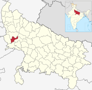
Hathras district is a district of Uttar Pradesh state of India. The city of Hathras is the district headquarters. Hathras district is a part of Aligarh division. The district occupies an area of 1,840 square kilometres (710 sq mi) and has a population of 1,564,708 as of the 2011 census.

Bargur Town in Tamil Nadu, India

Bargur is a selection-grade town panchayat in the Krishnagiri district of the Indian state of Tamil Nadu, that serves as the headquarters of Bargur taluk, one of the seven taluks in Krishnagiri district.

Vimanapura neighbourhood in Bangalore, Karnataka, India

Vimanapura or Baiyyappanahalli Vimanapura is an eastern suburb of Bangalore in Karnataka in India. It is so called because it is near Bangalore HAL airport. Vimanapura houses many of the HAL offices and the HAL hospital. The busy Old Airport Road goes through it.

Ramanagar, Belgaum Village in Karnataka, India

Ramanagar is a village in Belgaum district of Karnataka, India.

Baiyyappanahalli neighbourhood in Bengaluru, Karnataka, India

Baiyyappanahalli or New Baiyyappanahalli Extension is one of the neighbourhoods in Bengaluru. It is part of C. V. Raman Nagar in East Bengaluru. The area is a transport hub and popular for Baiyappanahalli metro station and Baiyyappanahalli railway station.

Baiyyappanahalli Manavarthe Kaval neighbourhood in Bengaluru, Karnataka, India

Baiyyappanahalli Manavarthe Kaval or Old Baiyyappanahalli is one of the early settlements in Bengaluru. It is part of C. V. Raman Nagar Assembly constituency in East Bengaluru. This former village was included in the Bangalore Mahanagara Palike on 7 December 1995.

Ramanagar, Indi village in Karnataka, India

Ramanagar is a village in the southern state of Karnataka, India. It is located in the outskirts of Indi situated in Indi Taluk of Bijapur.

Ramnagar, Bijapur village in Karnataka, India

Ramnagar is a village in the southern state of Karnataka, India. It is situated in Bijapur Taluk of Bijapur.

Ramnagar, Uttara Kannada village in Karnataka, India

Ramnagar is a village in the southern state of Karnataka, India. It is situated in Joida Taluk of Uttara Kannada.

Ramnagar, Gulbarga village in Karnataka, India

Ramnagar is a village in the southern state of Karnataka, India. It is situated in Afzalpur Taluk of Gulbarga.

Ramnagar, Yadgir village in Karnataka, India

Ramnagar is a village in the southern state of Karnataka, India. It is situated in Shorapur Taluk of Yadgir.

Guttahalli, Kolar Gold Fields village in Karnataka, India

Guttahalli is a small village in the Kolar Gold Fields Taluk of Kolar district in Karnataka, India. It is situated about 4 kilometers from Kolar Gold Fields, forming the outskirts of the city.

Guttahalli, Bangarapet North village in Karnataka, India

Guttahalli is a small village in the Bangarapet Taluk of Kolar district in Karnataka, India. It is situated about 7 kilometers from Bangarapet.

Guttahalli, Bangarapet South village in Karnataka, India

Guttahalli is a small village in the Bangarapet Taluk of Kolar district in Karnataka, India. It is situated about 7 kilometers from Bangarapet.

Guttahalli, Kolar West village in Karnataka, India

Guttahalli is a small village in the Kolar Taluk of Kolar district in Karnataka, India. It is situated about 25 kilometers from Kolar.

Guttahalli, Kolar South village in Karnataka, India

Guttahalli is a small village in the Kolar Taluk of Kolar district in Karnataka, India. It is situated about 15 kilometers from Kolar.

Guttahalli, Chintamani (village code 624567) village in Karnataka, India

Guttahalli is a small village in the Chintamani Taluk of Chikkaballapura district in Karnataka, India. It is situated about 9 kilometers from Chintamani.

Guttahalli, Chintamani (village code 624588) village in Karnataka, India

Guttahalli is a small village in the Chintamani Taluk of Chikkaballapura district in Karnataka, India. It is situated about 12 kilometers from Chintamani.

Hulkur village in Karnataka, India

Hulkur is a small village in the Malur Taluk of Kolar district in Karnataka, India. It is situated about 13 kilometers from Malur.

References

  1. "2011 census". censusindia.gov.in. Retrieved 8 January 2021.
  2. "DISTRICT CENSUS HANDBOOK, BIJAPUR" (PDF). censusindia.gov.in. Retrieved 8 January 2019.
  3. "2011 census". censusindia.gov.in. Retrieved 8 January 2021.
  4. "List of villages and towns - 2011 census". censusindia.gov.in. Retrieved 8 January 2019.