Salotgi

Last updated

Salotgi
village
India Karnataka location map.svg
Red pog.svg
Salotgi
Location in Karnataka, India
India location map.svg
Red pog.svg
Salotgi
Salotgi (India)
Coordinates: 17°10′N75°58′E / 17.17°N 75.96°E / 17.17; 75.96 Coordinates: 17°10′N75°58′E / 17.17°N 75.96°E / 17.17; 75.96
CountryFlag of India.svg  India
State Karnataka
District Bijapur
Talukas Indi
Population (2001)
  Total 10,664
Languages
  Official Kannada
Time zone IST (UTC+5:30)

Salotgi is a village in the southern state of Karnataka, India. [1] [2] It is located in the Indi taluk of Bijapur district in Karnataka. It is about 7–8 km from Indi.

Karnataka State in southern India

Karnataka is a state in the south western region of India. It was formed on 1 November 1956, with the passage of the States Reorganisation Act. Originally known as the State of Mysore, it was renamed Karnataka in 1973. The state corresponds to the Carnatic region. The capital and largest city is Bangalore (Bengaluru).

Indi, Karnataka town in Karnataka, India

Indi is a town in the state of Karnataka, India. It is the taluk headquarters of Indi Taluk, in the district of Bijapur.

Bijapur district, Karnataka District in South India, India

Bijapur district, officially known as Vijaypur district, is a district in the state of Karnataka in India. The city of Bijapur is the headquarters of the district, and is located 530 km northwest of Bangalore. Bijapur is well known for the great monuments of historical importance built during the Adil Shahi dynasty.

Contents

Demographics

As of 2001 India census, Salotgi had a population of 10,664 with 5,481 males and 5,183 females. [1]

Census Acquiring and recording information about the members of a given population

A census is the procedure of systematically acquiring and recording information about the members of a given population. The term is used mostly in connection with national population and housing censuses; other common censuses include agriculture, business, and traffic censuses. The United Nations defines the essential features of population and housing censuses as "individual enumeration, universality within a defined territory, simultaneity and defined periodicity", and recommends that population censuses be taken at least every 10 years. United Nations recommendations also cover census topics to be collected, official definitions, classifications and other useful information to co-ordinate international practice.

Salotgi as a centre of learning in the 11th century

According to A.S. Altekar in Education in Ancient India:

The village of Salotgi in Bijapur District of the Bombay Presidency was a famous centre, probably of Vedic learning, in the 10th and 11th centuries C.E. The Sanskrit college that flourished at this place must have existed for a long time, for it eventually transformed the original name of the place, Pavittage, into Salotgi, which is an abbreviated and Prakristised compound of Sala and Pavittage. The college was located in a spacious hall, attached to the temple of Tray-Purusha, which was built by Narayana, a minister of the Rashtrakuta emperor Krishna III. Owing to its far spread fame for efficiency, the college could attract students from different parts of the country. The strength of the college is not known, but it seems that 27 houses were necessary for lodging the students. An endowment of 12 Nivartanas(probably equal to 60 acres) of land was made for meeting the lighting charges of the boarding houses. The students were offered free boarding, an endowment of 500 Nivartanas having been received for that purpose. It would appear that at least 200 students were offered free boarding, lodging and education at this institution. [3]

Transportation

Salotgi can be reached by K.S.R.T.C buses from Indi which is 7–8 km away. the nearest railway station is Indi Road Railway which is connected to Solapur and Bijapur. Some private buses can be accessed to reach Salotgi. The nearest airport is Solapur. One can also reach Salotgi by hiring a tum tum(a slightly larger auto-rickshaw that can carry up to 10 people, locally known as "tum-tum" due to the engine sound heard from this vehicle) from Indi.

Karnataka State Road Transport Corporation

The Karnataka State Road Transport Corporation (KSRTC)is a state-owned road transportation company in the state of Karnataka in India. Corporation has the largest fleet of Volvo buses among state owned transport companies in India. It is wholly owned by the Government of Karnataka.

Solapur Metropolis in Western India, India

Solapur is a city located in the south-western region of the Indian state of Maharashtra. Solapur is located on major Highway, rail routes between Mumbai,Pune, Bangalore and Hyderabad, with a branch line to the cities of Bijapur and Gadag in the neighbouring state of Karnataka.& Solapur Is well connected through Airlines way.& Also Solapur international Airport is under construction. It is classified as a 1 Tier and B-1class city by House Rent Allowance (HRA) classification by the Government of India. It is the 5th biggest city in Maharashtra and the 49th most populous city in India and 43rd largest urban agglomeration.

Places of interest

Gramadevata is a Sanskrit term for the presiding deity or guardian deity in Hindu villages, towns and cities. It is derived from the words grāma “village” and devatā “deity”. Traditionally Kal Bhairav, a fierce form of Lord Shiva is the Gramadevata in the rural villages of Maharashtra, where he is referred to as Vairavar.

See also

Related Research Articles

Dharmasthala Temple Town in Karnataka, India

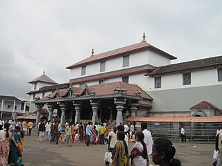
Dharmasthala is an Indian temple town on the banks of the Nethravathi River in the Belthangady taluk of the Dakshina Kannada district in Karnataka, India. It is a panchayat village, and it is the only village in its gram panchayat.

Osmanabad City in Maharashtra, India

Osmanabadpronunciation  is a city and a municipal council in Osmanabad district in the Indian state of Maharashtra. Osmanabad derives its name from the last ruler of Hyderabad, Mir Osman Ali Khan.

Akkalkot Town in Maharashtra, India

Akkalkotpronunciation  is a town and a municipal council in Solapur district in the Indian state of Maharashtra. It is situated 40 km southeast of Solapur and very close to the border between Maharashtra and Karnataka states.

Tuljapur city in Maharashtra, India

Tuljapur is a town with a municipal council in Osmanabad district in the Indian state of Maharashtra. It is the administrative seat of Tuljapur taluka.

Narasimharajapura Taluk in Karnataka, India

Narasimharajapura is a panchayat town and taluk headquarters in Chikkamagaluru district in the Indian state of Karnataka. Nearest Railway stations are Bhadravathi and Shivamogga. It was called Yedehalli till 1882. Shri benjamin luis has included under epigraphy of Karnataka in 6th Samputa. In 1915, yuvaraja shri narasimharaja wodeyar visited Yedehalli and in his memory, this was named after him as Narasimharajapura, now called N.R. Pura. This taluk had 65 gramas, as of date 42 shasanas are available. This taluk was ruled by Ganga, Kadamba, Santhara, Hoysala and vijayanagara kings.

Sindagi City in Karnataka, India

Sindagi is a City and Taluk in Bijapur district in the Indian state of Karnataka, about 60 km to the east of Bijapur. Sindagi is also Famous for Education. ವಿದ್ಯಾಕಾಶಿ of Vijaypura District.

Almel Town in Karnataka, India

Almel is a town in the southern state of Karnataka, India. It is located in the Sindagi taluk of Bijapur district in Karnataka.

Atharga Village in Karnataka, India

Atharga (ಅಥರ್ಗಾ) is a village in the southern state of Karnataka, India. It is located in the Indi taluk of Bijapur district in Karnataka.

Huvina Hipparagi Town in Karnataka, India

Huvina Hipparagi also Huvin Hipparagi is a Town in the southern state of Karnataka, India. It is located in the Basavana Bagevadi taluk of Bijapur district in Karnataka.

Nagathan village in Karnataka, India

Nagathan is a village in the southern state of Karnataka, India. It is located in the Bijapur taluk of Bijapur district in Karnataka.

Agasanal village in Karnataka, India

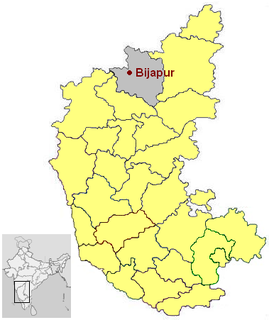
Agasanal is a village in the southern state of Karnataka, India. It is located in the Indi taluk of Bijapur district in Karnataka.

Gunadal village in Karnataka, India

Gunadal is a panchayat village in the state of Karnataka, India. Administratively it is under Bijapur Taluka of Bijapur district, Karnataka. Located in the far southwestern corner of the district, Gunadal is nearly 45 km by road from the district headquarters, the city of Bijapur. In Gunadal there is a Government Ayurvedic Hospital, Government Veterinary Hospital, Post Office, Police Station and gram panchayat headquarters.

Kambagi village in Karnataka, India

Kambagi is a panchayat village in the southern state of Karnataka, India. Administratively it is under Vijayapur Taluk of Vijayapur District, Karnataka. It is nearly 40 kilometres (25 mi) from district headquarters, the city of Vijayapur, Karnataka. Kambagi has Government Primary HealthCare Center, Post Office, Bank of India and Gram Panchayat offices.

Katakanahalli village in Karnataka, India

Katakanahalli or Katnalli is a village in the southern state of Karnataka, India. Administratively it is under the panchayat village of Hegadihal, in Bijapur Taluka of Bijapur District, Karnataka. It is nearly 15 km from the district headquarters in the city of Bijapur. It's one of the small villages near to Bijapur city.

Ballolli village in Karnataka, India

Ballolli is a village in the southern state of Karnataka, India. It is located in the Indi taluk of Bijapur district in Karnataka.

Zalaki village in Karnataka, India

Zalaki is a village in the southern state of Karnataka, India. It is located in the Indi Taluk of Bijapur district, Karnataka.

Lachyan, Karnataka village in Karnataka, India

Lachyan is a village located in Indi taluk, Bijapur district, Karnataka, India. The total area of Lachyan is 2517 hectares. The nearest town to Lachyan, Indi, is 12 kilometres (7.5 mi) away.

References

  1. 1 2 Village code= 212200 "Census of India : Villages with population 5000 & above". Registrar General & Census Commissioner, India. Retrieved 2008-12-18.
  2. "Yahoomaps India :" . Retrieved 2008-12-18. Salotgi, Bijapur, Karnataka
  3. A.S.Altekar: Education in Ancient India, Benaras, 1944