Hapton Valley Colliery

Last updated

Hapton Valley Colliery was a coal mine on the edge of Hapton near Burnley in Lancashire, England. Its first shafts were sunk in the early 1850s and it had a life of almost 130 years, surviving to be the last deep mine operating on the Burnley Coalfield.

Contents

Geology

The Burnley Coalfield, separated from the South Lancashire Coalfield, is in the form of an oval bowl extending north-east from Blackburn, past Colne to the Pennine Hills. Bounded by the Pendle monocline to the north and the Rossendale Valley anticline to the south, the coalfield is dissected by a series of predominately north-westerly trending faults, the most significant fault is the Cliviger Valley Fault at Burnley with a throw of up to 400 metres (1,300 ft) in Cliviger valley. The intersecting Theiveley Lead Mine Fault is one of a smaller number of easterly aligned structures. Unlike South Lancashire, only the Lower Westphalian coal measures are available. [1] The hills above are formed of Carboniferous sandstones, ranging from millstone grits to finer grained stone such as the Dyneley Knott flags and the Dandy Mine Rock. The drift cover consists primarily of glacial till deposits, which cause poor-drainage soils. [2]

Hapton Valley worked the Upper Mountain and Lower Mountain / Union seams in a syncline that extends from the Thieveley Fault, north-west to Higham where it outcrops. The area is split centrally by the Deerplay Fault with a throw of up to 100 metres (330 ft), which runs from White Hill (near Crown Point), under the eastern side of Hameldon Hill and Burnley's Lowerhouse district. [3] [4] The coal extracted from the Upper and Lower Mountain seams was ideal for producing high grade metallurgical coke which was in high demand in industry. [5]

Early history

The confluence of Hapton Clough and Habergham Clough in Spa Wood. Green Brook, Spa Wood.jpg
The confluence of Hapton Clough and Habergham Clough in Spa Wood.

Beginning in 1853 at Spa Wood, two shafts where sunk to a depth of 128 metres (420 ft) for the Exors of John Hargreaves Ltd. [3] The site was on a spit of land between Hapton and Habergham Cloughs, just south of where they combine to form Green Brook. [6] The shafts were on the north-west side of the Deerplay fault and although the Lower Mountain mine was reached, the pit was sunk in an area where it merges with the Upper Foot mine. The difficult geological conditions led to both shafts being partially filled, and the Upper Mountain mine being worked. [lower-alpha 1] [3] Coal was transported underground, raised to the surface and delivered onwards on a network of tram roads, known locally as ginny roads or tracks, by wheeled iron tubs drawn by an endless-chain system which was driven by a stationary steam engine. The tubs ran along circuits made of 22 inch gauge, angle-iron tracks but as the seam only averaged 0.84 metres (2 ft 9 in) in height, shorter tubs with half the capacity were used underground. Two drifts cut into the hillside connected the underground system to the surface and provided access for the miners.

On the surface, the ginny track delivered the coal to a coking plant at Barclay Hills Colliery to the northeast, and ultimately connected to the Leeds and Liverpool Canal at Gannow in Burnley. [7] [8] [6] By 1868, the underground tracks had reached 1,394 metres (1,524 yd) and 970 metres (1,060 yd) in length and about 370 tonnes of coal per day was raised. [9] [lower-alpha 2] but sometime later, problems with faulting and water ingress led to mining being stopped. [10]

Expansion

In the 1880s the shafts were increased in diameter and larger pumping equipment was installed and mining resumed by 1890. [3] The horizontal, condensing steam engine powered four bucket-lifts but a system of specially designed automatic fill and empty barrels was also employed to raise 1,000,000 gallons of water per day from the workings. [11] By 1908 work had commenced on two new shafts (No. 3 and No. 4) 200 metres north-west. They were completed to a depth of 157 metres (515 ft) by 1910. Manpower was transferred from the old site, with Spa Pit (No.1) closing in 1935. [3] [12] No. 2 shaft continued to be used for pumping. [13] In the early 1940s a small surface drift was driven from Thorney Bank Clough behind the Hapton Inn to speed-up access for the miners. [14] [lower-alpha 3]

Later years

Buildings at the former Thorny Bank Colliery. Thorny Bank Colliery.jpg
Buildings at the former Thorny Bank Colliery.

After nationalisation in 1947, the National Coal Board decided to develop Thorny Bank Colliery 53°46′19″N2°18′58″W / 53.772°N 2.316°W / 53.772; -2.316 (Thorney Bank) to the west which began operation in 1952, utilising the Thorney Bank Clough drift for ventilation. [15] They still saw a future for Hapton Valley, and investment followed, moving its area of operation to the east. In the early 1950s new tub circuits with an increased capacity were installed and work on new drifts heading east from the pit bottom, cutting through the Deerplay Fault, was completed in 1954. The same year a 3300 volt, 200 horsepower electric winder replaced the old steam-driven one. [16] In October 1957, work had to be stopped for several months on one of the new eastern faces after only two weeks in operation because of water ingress estimated at between 700 and 800 gallons per minute. Pumping equipment costing £10,000 was required to bring the problem under control. [17] The ginny track system came to an end for the transport of coal in 1958 when it was replaced by a system of conveyors. [lower-alpha 4] In 1961 one final 1,150 metres (1,260 yd) surface drift was cut and future operations were mechanised. [3] [13]

In 1962 the colliery employed 67 on the surface and 386 men below ground working two faces in the Union seam where production had increased to approximately 700 tons per day. No. 3 shaft was the main winding shaft, No. 4 was equipped with an electrically-driven exhausting fan and used for winding men only. A second exhaust fan was located about half a mile along the main return airway but its use was discontinued after the completion of the surface drift. [13] The method employed at the time (longwall mining) involved digging two tunnels at either side of the coal face, the intake and return gates, for access and ventilation. To facilitate the placement of a conveyor and electric cutting machine, recesses were cut into each end of the face, known as stables. As the coal was removed and the conveyor advanced, the waste rock was packed into each side of the void and the props removed to allow the roof to cave-in in a controlled manner. The primary means of breaking rock and coal was explosive shot cartridges detonated in a series of boreholes. [19] A coal plough was used in the Upper Mountain mine and an Anderton Shearer Loader in the Union. In 1978–79, the colliery's most productive year, 237,425 tonnes of coal were raised. [20]

Closure

Buildings on the Hapton Valley site today. Hapton Valley Colliery 2.jpg
Buildings on the Hapton Valley site today.

Hapton Valley survived to be Burnley's last deep mine, operating into the 1980s. By this time the risks associated with mining near flooded workings was considered too great and Hapton Valley Colliery was closed on 26 April 1982. [3] The winding gear was demolished at the start of 1983 but many surface buildings survived and the surface drift and shafts were capped. [10] It has been estimated that the proximity of the Deerplay fault, which created a 450-metre-wide barren zone, effectively reduced the exploitable reserves by 1,500,000 tons. [21]

Incidents

A warning of the dangers of mining occurred in 1855, when a 14-year-old boy was killed and his two companions injured by an explosion that occurred when they entered one of the old workings using a candle for light. [22] The seams worked at Hapton Valley were "gassy", with very high levels of firedamp recorded at the face. Although the use of powerful ventilation may have been linked to an increased occurrence of pneumoconiosis (miner's lung) in the Burnley Coalfield, no major explosions were recorded in the district until the 1960s. [23] Occasional serious incidents had occurred such as the 1856 death of a banksman who was repairing the steam engine, and a fire which destroyed the winding house in 1908. [24]

Two ignitions of gas occurred at number one coal face during the summer of 1960 and work there was subsequently discontinued. A third ignition occurred in the return gate stable on number two face on 4 April 1961. Then just after 9:45AM on 22 March 1962, an explosion in number two district killed 16 men instantly and 3 of the 16 seriously injured men died in hospital. The official report stated that the explosion likely caused by a firedamp ignition, possibly combined with coal dust, originating either in the return gate stable or at a point in the return gate between 165 to 256 metres (180 to 280 yd) from the face. While the ignition was probably the result of shotfiring, or from a flash produced by a thermite reaction involving aluminium foil and rusty iron, the source of the gas was not conclusively identified. [13] The victims are remembered with plaques at St Mark's Church on Rossendale Road, and at Burnley Miners Club, which holds an annual reunion. [25] [26]

See also

Related Research Articles

<span class="mw-page-title-main">Dunnockshaw</span> Human settlement in England

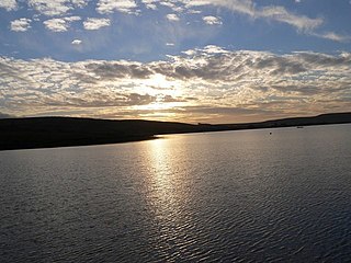
Dunnockshaw or Dunnockshaw and Clowbridge is a civil parish in the borough of Burnley, in Lancashire, England. The parish is situated between Burnley and Rawtenstall. According to the United Kingdom Census 2011, the parish has a population of 185.

<span class="mw-page-title-main">Tower Colliery</span> Historic Welsh coal mine active until 2008

Tower Colliery was the oldest continuously working deep-coal mine in the United Kingdom, and possibly the world, until its closure in 2008. It was the last mine of its kind to remain in the South Wales Valleys. It was located near the villages of Hirwaun and Rhigos, north of the town of Aberdare in the Cynon Valley of South Wales.

Clifton Hall Colliery was one of two coal mines in Clifton on the Manchester Coalfield, historically in Lancashire which was incorporated into the City of Salford in Greater Manchester, England in 1974. Clifton Hall was notorious for an explosion in 1885 which killed around 178 men and boys.

Agecroft Colliery was a coal mine on the Manchester Coalfield that opened in 1844 in the Agecroft district of Pendlebury, Lancashire, England. It exploited the coal seams of the Middle Coal Measures of the Lancashire Coalfield. The colliery had two spells of use; the first between 1844 and 1932, when the most accessible coal seams were exploited, and a second lease of life after extensive development in the late 1950s to access the deepest seams.

The South Yorkshire Coalfield is so named from its position within Yorkshire. It covers most of South Yorkshire, West Yorkshire and a small part of North Yorkshire. The exposed coalfield outcrops in the Pennine foothills and dips under Permian rocks in the east. Its most famous coal seam is the Barnsley Bed. Coal has been mined from shallow seams and outcrops since medieval times and possibly earlier.

<span class="mw-page-title-main">Chatterley Whitfield</span> Disused coal mine in Chell, Staffordshire, England

Chatterley Whitfield Colliery is a disused coal mine on the outskirts of Chell, Staffordshire in Stoke on Trent, England. It was the largest mine working the North Staffordshire Coalfield and was the first colliery in the UK to produce one million tons of saleable coal in a year.

The Minnie Pit disaster was a coal mining accident that took place on 12 January 1918 in Halmer End, Staffordshire, in which 155 men and boys died. The disaster, which was caused by an explosion due to firedamp, is the worst ever recorded in the North Staffordshire Coalfield. An official investigation never established what caused the ignition of flammable gases in the pit.

<span class="mw-page-title-main">Lancashire Coalfield</span> Coal mining region in England

The Lancashire Coalfield in North West England was an important British coalfield. Its coal seams were formed from the vegetation of tropical swampy forests in the Carboniferous period over 300 million years ago.

<span class="mw-page-title-main">Ingleton Coalfield</span> Coalfield in North Yorkshire, England

The Ingleton Coalfield is in North Yorkshire, close to its border with Lancashire in north-west England. Isolated from other coal-producing areas, it is one of the smallest coalfields in Great Britain.

Bedford Colliery, also known as Wood End Pit, was a coal mine on the Manchester Coalfield in Bedford, Leigh, Lancashire, England. The colliery was owned by John Speakman, who started sinking two shafts on land at Wood End Farm in the northeast part of Bedford, south of the London and North Western Railway's Tyldesley Loopline in about 1874. Speakman's father owned Priestners, Bankfield, and Broadoak collieries in Westleigh. Bedford Colliery remained in the possession of the Speakman family until it was amalgamated with Manchester Collieries in 1929.

<span class="mw-page-title-main">Bickershaw Colliery</span> Former coal mine in Lancashire, England

Bickershaw Colliery was a coal mine, located on Plank Lane in Leigh, then within the historic county boundaries of Lancashire, England.

Pendleton Colliery was a coal mine operating on the Manchester Coalfield after the late 1820s on Whit Lane in Pendleton, Salford, then in the historic county of Lancashire, England.

<span class="mw-page-title-main">Bradford Colliery</span> Coal mine

Bradford Colliery was a coal mine in Bradford, Manchester, England. Although part of the Manchester Coalfield, the seams of the Bradford Coalfield correspond more closely to those of the Oldham Coalfield. The Bradford Coalfield is crossed by a number of fault lines, principally the Bradford Fault, which was reactivated by mining activity in the mid-1960s.

The Tarenni Colliery and its associated workings, are a series of coal mines and pits located between the villages of Godre'r Graig and Cilybebyll located in the valley of the River Tawe, in Neath Port Talbot county borough, South Wales.

<span class="mw-page-title-main">Hameldon Hill</span>

Hameldon Hill is a Carboniferous sandstone hill with a summit elevation of 409 metres (1,342 ft), situated between the towns of Burnley and Accrington in Lancashire, England. It is listed as a "HuMP" or "Hundred Metre Prominence", its parent being Freeholds Top, a Marilyn near Bacup.

This is a partial glossary of coal mining terminology commonly used in the coalfields of the United Kingdom. Some words were in use throughout the coalfields, some are historic and some are local to the different British coalfields.

<span class="mw-page-title-main">Burnley Coalfield</span> Coal mining region in England

The Burnley Coalfield is the most northerly portion of the Lancashire Coalfield. Surrounding Burnley, Nelson, Blackburn and Accrington, it is separated from the larger southern part by an area of Millstone Grit that forms the Rossendale anticline. Occupying a syncline, it stretches from Blackburn past Colne to the Yorkshire border where its eastern flank is the Pennine anticline.

<span class="mw-page-title-main">Bank Hall Colliery</span> Decommissioned coal mine in Lancashire

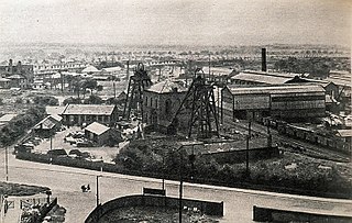
Bank Hall Colliery was a coal mine on the Burnley Coalfield in Burnley, Lancashire near the Leeds and Liverpool Canal. Sunk in the late 1860s, it was the town's largest and deepest pit and had a life of more than 100 years.

<span class="mw-page-title-main">Ellesmere Colliery</span> Former coal mine in Walkden, Manchester, England

Ellesmere Colliery was a coal mine in Walkden, Manchester, England. The pit was located on Manchester Road, a short distance south of Walkden town centre.

References

Notes

  1. In this part of Lancashire a coal seam is referred to as a mine and the coal mine as a colliery or pit.
  2. By the 1890s the surface ginny road also connected Hapton Valley to Porters Gate Colliery in the southeast [6]
  3. After 1950 Thorney Bank Colliery utilised the drift for ventilation. [14]
  4. The surface tracks did not appear on the 1961 Ordnance Survey map. [18]

Citations

  1. Williamson 1999, pp. 4–8
  2. Hapton Heritage 2013, p. 4
  3. 1 2 3 4 5 6 7 Hapton Valley & NMRS
  4. Hough 2004, p. 20
  5. Williamson 1999, p. 8
  6. 1 2 3 Lancashire and Furness (Map). 1 : 2,500. County Series. Ordnance Survey. 1893.
  7. Tail-rope report 1868, pp. 54–70
  8. Hapton Heritage 2013, p. 20
  9. Tail-rope report 1868, p. 59
  10. 1 2 Nadin 1997, p. 91
  11. Nadin 1997, p. 92
  12. Lancashire and Furness (Map). 1 : 2,500. County Series. Ordnance Survey. 1912.
  13. 1 2 3 4 Explosion report 1962, p. 3
  14. 1 2 Nadin 1997, p. 94
  15. Thorny Bank & NMRS
  16. Nadin 1997, p. 95
  17. Nadin 1997, p. 96
  18. Lancashire and Furness (Map). 1 : 2,500. County Series. Ordnance Survey. 1961.
  19. Explosion report 1962, pp. 4, 10
  20. Nadin 1997, pp. 98, 101
  21. Williamson 1999, p. 18
  22. Nadin 1997, p. 89
  23. Williamson 1999, pp. 20–21
  24. Nadin 1997, pp. 89–91
  25. Lancashire Telegraph 2012.
  26. BBC News 2012.

Bibliography

53°46′41″N2°17′31″W / 53.778°N 2.292°W / 53.778; -2.292