Harlis, Minnesota

Last updated

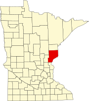
Harlis is a ghost town in Pine County, in the U.S. state of Minnesota. [1]

History

A post office called Harlis was established in 1914, and remained in operation until 1932. [2] Harlis had a depot on the Soo Railroad. [3]

Related Research Articles

<span class="mw-page-title-main">Pine County, Minnesota</span> County in Minnesota, United States

Pine County is a county in the U.S. state of Minnesota. As of the 2020 census, the population was 28,876. Its county seat is Pine City. The county was formed in 1856 and organized in 1872.

West Crow Wing is an unorganized territory in Crow Wing County, Minnesota, United States. The population was 5,144 at the 2000 census. It is part of the Brainerd Micropolitan Statistical Area.

Heikkala Lake is an unorganized territory in Saint Louis County, Minnesota, United States. The population was 322 at the 2000 census.

Mud Hen Lake is an unorganized territory in Saint Louis County, Minnesota, United States. The population was 320 at the 2000 census.

<span class="mw-page-title-main">Miesville Ravine Park Reserve</span> River in Minnesota, United States

Miesville Ravine Park Reserve is a Dakota County park near the town of Miesville, Minnesota, United States. It preserves over 1,600 acres (6 km2) of biologically diverse land in the Cannon River valley. Most of the park is wooded with mature oak, maple, cottonwood, willow, red cedar, and white pine. A trout stream, Trout Brook, is located in the reserve.

<span class="mw-page-title-main">Minnesota Point</span> Neighborhood in Duluth, Minnesota, United States of America

Minnesota Point, also known as the Park Point neighborhood of Duluth, Minnesota, United States; is a long, narrow sand spit that extends out from the Canal Park tourist recreation-oriented district of the city of Duluth. The Point separates Lake Superior from Superior Bay and the Duluth Harbor Basin.

Cedar is an unincorporated community in Butler Township, DeKalb County, Indiana.

The Grindstone River is a 6.7-mile-long (10.8 km) river of Minnesota, a tributary of the Kettle River. Its name is derived either from the Dakota Iŋswú watpá or from the Ojibwe Zhiigwanaabikokaa-ziibi. Sandstone taken from near the river was used to produce sharpening stones. In Ojibwe, Hinckley (Gaa-zhiigwanaabikokaag) is named after this river.

The Net River is a 24.5-mile-long (39.4 km) tributary of the South Fork Nemadji River in Pine and Carlton counties, Minnesota, United States. Via the Nemadji River, it flows to Lake Superior at Superior, Wisconsin.

The Pine River is a 23.0-mile-long (37.0 km) tributary of the Kettle River in eastern Minnesota, United States. It begins at the outlet of Big Pine Lake near the western border of Pine County, Minnesota, and flows northeast and east, reaching the Kettle River at Rutledge.

The Pine River is a 56.9-mile-long (91.6 km) tributary of the Mississippi River in northern Minnesota, United States.

Corona is an unincorporated community in Carlton County, in the U.S. state of Minnesota. Corona is located at 46°40′14″N92°45′59″W.

Pine Lake may refer to two separate lakes in Chisago County, Minnesota

Banning is a ghost town in Pine County, in the U.S. state of Minnesota.

Belden is a ghost town in Pine County, in the U.S. state of Minnesota.

Tinney is an unincorporated community in Sandusky County, in the U.S. state of Ohio.

Beebe is an unincorporated community in Athens County, in the U.S. state of Ohio.

Unfried is an extinct town in Garfield County, in the U.S. state of Washington.

McNatt is an unincorporated community in north central McDonald County, in the U.S. state of Missouri.

Galesburg is an unincorporated community in Putnam County, in the U.S. state of Missouri.

References

  1. U.S. Geological Survey Geographic Names Information System: Harlis, Minnesota
  2. "Pine County". Jim Forte Postal History. Retrieved July 30, 2015.
  3. Upham, Warren (1920). Minnesota Geographic Names: Their Origin and Historic Significance. Minnesota Historical Society. p. 412.

46°24′44″N92°18′46″W / 46.41222°N 92.31278°W / 46.41222; -92.31278