West Rock, Minnesota

Last updated
West Rock
USA Minnesota location map.svg
Red pog.svg
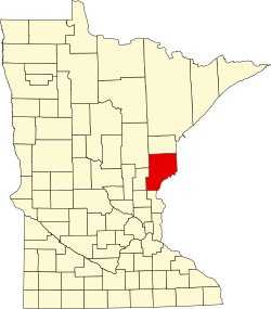
West Rock
Location of the community of West Rock
within Royalton Township, Pine County
Usa edcp location map.svg
Red pog.svg
West Rock
West Rock (the United States)
Coordinates: 45°46′02″N93°01′18″W / 45.76722°N 93.02167°W / 45.76722; -93.02167 Coordinates: 45°46′02″N93°01′18″W / 45.76722°N 93.02167°W / 45.76722; -93.02167
Country United States
State Minnesota
County Pine
Township Royalton Township
Elevation
994 ft (303 m)
Population
  Total10
Time zone UTC-6 (Central (CST))
  Summer (DST) UTC-5 (CDT)
ZIP code
55067
Area code(s) 320
GNIS feature ID654000 [1]

West Rock is an unincorporated community in Royalton Township, Pine County, Minnesota, United States.

State Highway 70 (MN 70) serves as a main route in the community, and Interstate 35 is nearby.

West Rock is located immediately west of Rock Creek along Highway 70.

The center of West Rock is generally considered at the intersection of Highway 70 (MN 70) and Pine County 103 (Elmcrest Avenue); which is also the boundary line between Royalton Township and the city of Rock Creek.

Related Research Articles

Pine County, Minnesota U.S. county in Minnesota

Pine County is a county in the U.S. state of Minnesota. As of the 2010 United States Census, the population was 29,750. Its county seat is Pine City. The county was formed in 1856 and organized in 1872.

Kanabec County, Minnesota U.S. county in Minnesota

Kanabec County is a county in the U.S. state of Minnesota. As of the 2010 United States Census, the population was 16,239. Its county seat is Mora.

Goodhue County, Minnesota County in the United States

Goodhue County is a county in the U.S. state of Minnesota. As of the 2010 census, the population was 46,183. Its county seat is Red Wing. Nearly all of Prairie Island Indian Community is within the county.

Carlton County, Minnesota County in the United States

Carlton County is a county in the State of Minnesota, formed in 1857. As of the 2010 United States Census, the population was 35,386. Its county seat is Carlton. Part of the Fond du Lac Indian Reservation lies in NE Carlton County.

Benton County, Minnesota County in the United States

Benton County is a county in the U.S. state of Minnesota. As of the 2010 United States Census, the population was 38,451. Its county seat is Foley.

Alborn, Minnesota Unincorporated community in Minnesota, United States

Alborn is an unincorporated community in Alborn Township, Saint Louis County, Minnesota, United States.

Minnesota State Highway 361 was a 7.281-mile-long (11.718 km) highway in east-central Minnesota, which ran from an interchange with Interstate 35 (I-35) in Rush City and continued briefly east and then north to MN 70 in Rock Creek. The roadway was formerly part of the U.S. Highway 61.

Pengilly, Minnesota Unincorporated community in Minnesota, United States

Pengilly is an unincorporated community in eastern Itasca County, Minnesota, United States.

Bear River, Minnesota Unincorporated community in Minnesota, United States

Bear River is an unincorporated community in Itasca and Saint Louis counties in the U.S. state of Minnesota.

Holyoke, Minnesota Unincorporated community in Minnesota, US

Holyoke is an unincorporated community in Holyoke Township, Carlton County, Minnesota, United States. It is located between Sandstone and Duluth.

Brunswick, Minnesota Unincorporated community in Minnesota, United States

Brunswick is an unincorporated community in Brunswick Township, Kanabec County, Minnesota, United States. The community is located between Mora and Rock Creek at the junction of State Highway 65 and State Highway 70.

Cloverdale, Minnesota Unincorporated community in Minnesota, United States

Cloverdale is an unincorporated community in Arlone Township, Pine County, Minnesota, United States.

Automba, Minnesota Unincorporated community in Minnesota, US

Automba is an unincorporated community in Automba Township, Carlton County, Minnesota, United States. The community is near Kettle River along Carlton County Road 6. State Highways 27 and 73 are nearby. Automba is 18 miles west-northwest of Moose Lake.

West Point, Minnesota Unincorporated community in Minnesota, United States

West Point is an unincorporated community in Isanti County, Minnesota, United States.

Goodland, Minnesota Unincorporated community in Minnesota, United States

Goodland is an unincorporated community in Goodland Township, Itasca County, Minnesota, United States.

Little Rock, Morrison County, Minnesota Unincorporated community in Minnesota, United States

Little Rock is an unincorporated community in Buckman Township, Morrison County, Minnesota, United States. There are around 1200 people living in Little Rock, MN. The community is located along State Highway 25 near its junction with Morrison County Road 26, Nature Road. Nearby places include Buckman, Royalton, Rice, and Pierz. Bunker Hill Creek flows through the community.

Silverdale, Minnesota Unincorporated community in Minnesota, United States

Silverdale is an unincorporated community in Koochiching County, Minnesota, United States; located in the southeast corner of the county.

Wildwood, Minnesota Unincorporated community in Minnesota, United States

Wildwood is an unincorporated community in Koochiching County, Minnesota, United States; located within the Pine Island State Forest.

Greeley, Minnesota Unincorporated community in Minnesota, United States

Greeley is an unincorporated community in Royalton Township, Pine County, Minnesota, United States.

References

  1. "West Rock, Minnesota". Geographic Names Information System . United States Geological Survey.