Henriette | |
---|---|
Coordinates: 45°52′17″N93°7′11″W / 45.87139°N 93.11972°W | |
Country | United States |
State | Minnesota |
County | Pine |
Incorporated | March 13, 1920 [1] |
Government | |
• Mayor | Giles Nelson [2] |
Area | |
• Total | 0.28 sq mi (0.73 km2) |
• Land | 0.28 sq mi (0.73 km2) |
• Water | 0.00 sq mi (0.00 km2) |
Elevation | 994 ft (303 m) |
Population (2023) | |
• Total | 59 |
• Density | 202.85/sq mi (78.41/km2) |
• Demonym | Henriettard |
Time zone | UTC-6 (Central (CST)) |
• Summer (DST) | UTC-5 (CDT) |
ZIP code | 55036 |
Area code | 320 |
FIPS code | 27-28574 [5] |
GNIS feature ID | 2394354 [4] |
Henriette, is a city in Pine County, Minnesota, United States. The population was 59 in 2023. [6]
Henriette was founded as Cornell. [7]
According to the United States Census Bureau, the city has a total area of 0.29 square miles (0.75 km2), all land. [8]
Minnesota State Highway 107 and Pine County 11 are two of the main routes in the community.
Census | Pop. | Note | %± |
---|---|---|---|
1930 | 128 | — | |
1940 | 148 | 15.6% | |
1950 | 57 | −61.5% | |
1960 | 65 | 14.0% | |
1970 | 56 | −13.8% | |
1980 | 61 | 8.9% | |
1990 | 78 | 27.9% | |
2000 | 101 | 29.5% | |
2010 | 71 | −29.7% | |
2020 | 57 | −19.7% | |
U.S. Decennial Census [9] |
As of the census [10] of 2010, there were 71 people, 32 households, and 19 families living in the city. The population density was 244.8 inhabitants per square mile (94.5/km2). There were 38 housing units at an average density of 131.0 per square mile (50.6/km2). The racial makeup of the city was 90.1% White, 1.4% Asian, 4.2% from other races, and 4.2% from two or more races. Hispanic or Latino of any race were 4.2% of the population.
There were 32 households, of which 28.1% had children under the age of 18 living with them, 31.3% were married couples living together, 15.6% had a female householder with no husband present, 12.5% had a male householder with no wife present, and 40.6% were non-families. 40.6% of all households were made up of individuals, and 15.7% had someone living alone who was 65 years of age or older. The average household size was 2.22 and the average family size was 2.84.
The median age in the city was 44.3 years. 22.5% of residents were under the age of 18; 8.4% were between the ages of 18 and 24; 21.1% were from 25 to 44; 25.3% were from 45 to 64; and 22.5% were 65 years of age or older. The gender makeup of the city was 54.9% male and 45.1% female.
As of the census [5] of 2000, there were 101 people, 37 households, and 24 families living in the city. The population density was 398.8 inhabitants per square mile (154.0/km2). There were 38 housing units at an average density of 150.0 per square mile (57.9/km2). The racial makeup of the city was 95.05% White, 1.98% Native American, 2.97% from other races. Hispanic or Latino of any race were 4.95% of the population.
There were 37 households, out of which 45.9% had children under the age of 18 living with them, 35.1% were married couples living together, 21.6% had a female householder with no husband present, and 35.1% were non-families. 27.0% of all households were made up of individuals, and 5.4% had someone living alone who was 65 years of age or older. The average household size was 2.73 and the average family size was 3.33.
In the city, the population was spread out, with 34.7% under the age of 18, 9.9% from 18 to 24, 31.7% from 25 to 44, 17.8% from 45 to 64, and 5.9% who were 65 years of age or older. The median age was 30 years. For every 100 females, there were 152.5 males. For every 100 females aged 18 and over, there were 112.9 males.
The median income for a household in the city was $28,542, and the median income for a family was $42,917. Males had a median income of $24,167 versus $16,250 for females. The per capita income for the city was $13,312. There were no families and 12.6% of the population living below the poverty line, including no under eighteens and none of those over 64.
Circle Pines is a city in Anoka County, Minnesota, United States. The population was 5,025 at the 2020 census.
Pine River is a city in Cass County, Minnesota, United States. The population was 911 at the 2020 census. It is part of the Brainerd Micropolitan Statistical Area.
Crosslake is a city in Crow Wing County, Minnesota, United States. The population was 2,141 at the 2010 census. It is part of the Brainerd Micropolitan Statistical Area.
Little Pine Township is a township in Crow Wing County, Minnesota, United States. The population was 86 at the 2000 census. Little Pine Township took its name from the Little Pine River.
Bigfork is a city in Itasca County, Minnesota, United States. The population was 400 at the 2020 census. Scenic State Park is nearby.
Henning is a city in Otter Tail County, Minnesota, United States. The population was 854 at the 2020 census.
Pine Lake Township is a township in Otter Tail County, Minnesota, United States. The population was 656 at the 2000 census.
Urbank is a city in Otter Tail County, Minnesota, United States. The population was 52 at the 2020 census.
Brook Park is a city in Pine County, Minnesota, United States. The population was 139 at the 2010 census.
Bruno is a city in Pine County, Minnesota, United States. The population was 102 at the 2010 census.
Chengwatana Township is a township in Pine County, Minnesota, United States. The population was 809 at the 2000 census. Chengwatana Township was organized in 1874. Its name is derived from the Ojibwe Zhingwaadena, applied originally to an Ojibwe village located at the confluence of the Snake River with the St. Croix River. Neighbouring Pine City Township and the City of Pine City get their names from the English translation of Chengwatana.
Denham is a city in Pine County, Minnesota, United States. The population was 37 at the 2020 census.
Kerrick is a city in Pine County, Minnesota, United States. The population was 65 at the 2010 census.
Pine City Township is a township in Pine County, Minnesota, United States, located south and east of the city of Pine City. The township population was 1,249 at the 2000 census.
Rock Creek is a city in Pine County, Minnesota, United States. The population was 1,628 at the 2010 census. Portions of the Mille Lacs Indian Reservation are located within Rock Creek.
Rutledge is a city in Pine County, Minnesota, United States, at the confluence of the Kettle and Pine Rivers. The population was 229 at the 2010 census.
Sturgeon Lake is a city in Pine County, Minnesota, United States. The population was 439 at the 2010 census.
Pine Springs is a city in Washington County, Minnesota, United States. The population was 408 at the 2010 census.
Minnesota Lake is a city in Blue Earth and Faribault counties in the State of Minnesota. The population was 661 at the 2020 census. The bulk of the city is in Faribault County; a small part extends into Blue Earth County.
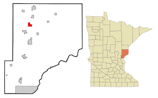
Pine Island is a city in Goodhue and Olmsted counties in the U.S. state of Minnesota. Most of Pine Island is in Goodhue County, but a small part extends into Olmsted County, making that portion part of the Rochester metropolitan area. As of the 2020 census, the population was 3,769.