
Banning [1] is a ghost town in Pine County, in the U.S. state of Minnesota. It is now a state park.
Banning [1] is a ghost town in Pine County, in the U.S. state of Minnesota. It is now a state park.
A post office called Banning was established in 1896, and remained in operation until 1912. [2] The community was named for William L. Banning, a railroad contractor and Democratic politician. [3] It is now located in Banning State Park, which was established in 1963.
| Census | Pop. | Note | %± |
|---|---|---|---|
| 1910 | 149 | — | |
| 1920 | 44 | −70.5% | |
| U.S. Decennial Census [4] | |||
Municipalities and communities of Pine County, Minnesota, United States | ||
|---|---|---|
| Cities | 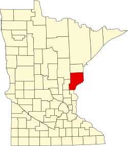 | |
| Townships | ||
| Unincorporated communities | ||
| Ghost towns | ||
| Indian reservation | ||
46°09′38″N92°51′07″W / 46.16056°N 92.85194°W
| | This United States ghost town-related article is a stub. You can help Wikipedia by expanding it. |