Beroun, Minnesota

Last updated

Beroun
USA Minnesota location map.svg
Red pog.svg
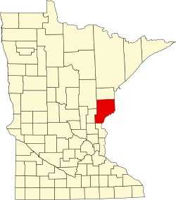
Beroun
Location of the community of Beroun
within Mission Creek Township, Pine County
Usa edcp location map.svg
Red pog.svg
Beroun
Beroun (the United States)
Coordinates: 45°54′37″N92°57′19″W / 45.91028°N 92.95528°W / 45.91028; -92.95528
Country United States
State Minnesota
County Pine
Township Mission Creek Township
Elevation
974 ft (297 m)
Population
  Total120
Time zone UTC-6 (Central (CST))
  Summer (DST) UTC-5 (CDT)
ZIP code
55063
Area code 320
GNIS feature ID639974 [1]

Beroun is an unincorporated community in Mission Creek Township, Pine County, Minnesota, United States.

Interstate 35 and Pine County Roads 14 and 61 are three of the main routes in the community. I-35 runs north–south, and County Road 14 (Beroun Crossing Road) runs east–west.

Beroun is between Hinckley and Pine City.

Founded circa 1882 as "Brown's Hill" along the Northern Pacific Railroad [2] line, it was renamed in 1895 when a post office called "Beroun" was established, and remained in operation until 1993. [3] The community was founded by Czech immigrants, who named it after the town of Beroun in the Czech Republic. Beroun was a station on the Northern Pacific Railroad. [4]

ZIP codes 55063 (Pine City), 55037 (Hinckley), and 55007 (Brook Park) all intersect near Beroun.

Related Research Articles

<span class="mw-page-title-main">Finlayson, Minnesota</span> City in Minnesota, United States

Finlayson is a city in Pine County, Minnesota, United States. The population was 315 at the 2010 census. The city's area was incorporated from Finlayson Township, the remainder of which is still adjacent to it.

<span class="mw-page-title-main">Hinckley, Minnesota</span> City in Minnesota, United States

Hinckley is a city in Pine County, Minnesota, United States, located at the junction of Interstate 35 and Minnesota State Highway 48. The population was 1,800 at the 2010 census.

<span class="mw-page-title-main">Pine City, Minnesota</span> City in Minnesota, United States

Pine City is a city in and the county seat of Pine County, in east central Minnesota, United States. The population was 3,130 at the 2020 census. Part of the city is on the Mille Lacs Indian Reservation. Founded as a railway town, it soon became a logging community and the surrounding lakes made it a resort town. Today, it is in part as a commuter town for people working in the Minneapolis–Saint Paul metropolitan area.

<span class="mw-page-title-main">Duquette, Minnesota</span> Unincorporated community in Minnesota, United States

Duquette is an unincorporated community in Pine County, Minnesota, United States; located along the Willow River.

<span class="mw-page-title-main">St. Croix Valley Railroad</span>

The St. Croix Valley Railroad is a Class III short line railroad that operates over 36 miles of track in eastern Minnesota. The railroad is owned by KBN Incorporated jointly between Independent Locomotive Service of Bethel MN and Midwest Locomotive Services of Atwater MN, with the railroad headquartered in Rush City, Minnesota.

<span class="mw-page-title-main">Atkinson, Indiana</span> Unincorporated community in Indiana, United States

Atkinson is an unincorporated community in Center Township, Benton County, in the U.S. state of Indiana. The site of Atkinson is home to the county's only junior/senior high school, Benton Central.

Philbrook is an unincorporated community in Todd County, Minnesota, United States. It is along Todd County Road 28 near Red Pine Road. Nearby places include Staples, Motley, Cushing, and Browerville.

<span class="mw-page-title-main">Cloverdale, Minnesota</span> Unincorporated community in Minnesota, United States

Cloverdale is an unincorporated community in Arlone Township, Pine County, Minnesota, United States.

Sperry is an unincorporated community in central Des Moines County, Iowa, United States. It lies along local roads north of the city of Burlington, the county seat of Des Moines County. Its elevation is 751 feet (229 m). Although Sperry is unincorporated, it has a post office with the ZIP code of 52650, which opened on 5 February 1870.

<span class="mw-page-title-main">Canyon Diablo, Arizona</span> Ghost town in Coconino County, Arizona

Canyon Diablo is a ghost town in Coconino County, Arizona, United States on the edge of the arroyo Canyon Diablo. The community was settled in 1880 and died out in the early 20th century.

Concord is an unincorporated community in Sussex County, Delaware, United States. Concord is located along Delaware Route 20, east of Seaford.

Groningen is an unincorporated community in Dell Grove Township, Pine County, Minnesota, United States.

Friesland is an unincorporated community in Dell Grove Township, Pine County, Minnesota, United States.

Margie is an unincorporated community in Koochiching County, Minnesota, United States; located near Big Falls.

<span class="mw-page-title-main">Markville, Minnesota</span> Unincorporated community in Minnesota, United States

Markville is an unincorporated community in Arna Township, Pine County, Minnesota, United States, located along the Saint Croix River.

Kingsdale is an unincorporated community in New Dosey Township, Pine County, Minnesota, United States.

Mission Creek is an unincorporated community in Mission Creek Township, Pine County, Minnesota, United States.

Faulkland is an unincorporated community in New Castle County, Delaware, United States, approximately two miles west of Wilmington. Faulkland has only one main road, Faulkland Road. No post office has ever existed in the very small community. The Wilmington and Western Railroad runs parallel through the area with a level crossing at Faulkland Road. Hyde Run, a Red Clay Creek tributary, runs through the area.

Astor was an unincorporated community in Crawford County, in the U.S. state of Iowa.

Bromley is a former village in Minerva Township, Marshall County, Iowa, United States.

References

  1. "Beroun, Minnesota". Geographic Names Information System . United States Geological Survey, United States Department of the Interior.
  2. Cram, George (1882). New indexed commercial atlas of the western and southern states. A complete guide for business men, showing all towns, post offices, rail and express routes, &c., &c. George Franklin Cram. p. 66-67.
  3. "Pine County". Jim Forte Postal History. Retrieved July 30, 2015.
  4. Upham, Warren (1920). Minnesota Geographic Names: Their Origin and Historic Significance. Minnesota Historical Society. p.  411.