Lake Lena, Minnesota

Last updated

Lake Lena
Aazhoomog
USA Minnesota location map.svg
Red pog.svg
Lake Lena
Location of the community of Lake Lena
within Ogema Township, Pine County
Coordinates: 46°03′41″N92°27′40.2″W / 46.06139°N 92.461167°W / 46.06139; -92.461167
Country United States
State Minnesota
County Pine
Township Ogema Township
Elevation
1,017 ft (310 m)
Time zone UTC-6 (Central (CST))
  Summer (DST) UTC-5 (CDT)
Area code 320
GNIS feature ID1815033 [1]

Lake Lena is an unincorporated community and Native American village in Ogema Township, Pine County, Minnesota, United States, located along the Lower Tamarack River. It currently is the administrative center for the Mille Lacs Indian Reservation, District III.

Contents

Lake Lena is located 25 miles east of Hinckley; and seven miles west-northwest of Danbury, Wisconsin. Lake Lena is 24 miles east-southeast of Sandstone.

Grace Lake Road (Pine County 173) serves as a main route in the community. State Highway 48 (MN 48) is nearby.

The community name in the Ojibwe language is Aazhoomog, meaning "Crossroads" in reference to being at the former crossroad of the north–south trail connecting Bikoganaagan (Danbury), via the former Agaming (Outflow/"Lower Tamarack River Village"), and the former Gibaakwa'iganing (Tozer Camp/"lower Upper Tamarack River Village") with the east–west trail connecting Mooningwanekaaning (La Pointe), via Namekaawa'iganing (Gordon), with Gaa-zhiigwanaabikokaag (Hinckley).

History

Pre-Dakota

Before the arrival of the Dakota Sioux, the area about Lake Lena was inhabited by the Cheyenne, Fox and Ho-Chunk, with migratory Gros Ventre, Mandwe and Menominee peoples. The Lake Lena area served as a place abundant with food, in the heart of the Folle Avoine Region, with Wild Rice and Sturgeon. In addition, the Lake Lena Village was located along the site of the annual Bear migratory path.

Dakota

With the arrival of the Dakota Sioux, only the Fox remained as permanent residents of the region. However, occasional Cheyenne, Ho-Chunk and Menominee peoples still came to the area for the Wild Rice. The Santee Sioux maintained a trade network routes offered by the St. Croix River, and the series of trails connecting the Lake Lena Village with Lake Superior, Mississippi River headwaters and other major upper Mississippi River destinations, Red Cedar River and Chippewa River. With the arrival of the Ojibwe from the cultural center in La Pointe, the area about the upper St. Croix River became a contested place. Though the Fox were permanently pushed out of the area, the Dakota and Ojibwe eventually came to peace and lived side-by-side.

Manoominikeshiinyag Ojibwe

After the Ojibwe had gained control of the upper St. Croix River valley, the Lake Lena area became one of many network of trade villages. However, in the 1825 First Treaty of Prairie du Chien, the United States formally drew the boundaries separating the Dakota and the Ojibwe. For the Lake Lena and other Manoominikeshiinyag Ojibwe, already intertwined with the Dakota, this posed a problem. With agreements, the more southern Dakota north of the "Prairie du Chien Line" moved south of the line with the more northern Dakota north of the line were adopted as "Ojibwe" and became the Wolf Totem. Meanwhile, many of the Ojibwe located south of the line were adopted into the Mdewakanton. By maintaining the trade network but with a different tribal association, Aazhoomog transitioned from a Dakota-Ojibwe village to a fully Ojibwe village. The Manoominikeshiinyag Ojibwe of the upper St. Croix River valley became one of the signatories to the 1837 Treaty of St. Peters and the 1842 Treaty of La Pointe. The 1837 treaty, dubbed the "White Pine Treaty", brought an influx of lumber industry. After the Sandy Lake Tragedy, the United States encouraged the consolidation of the Ojibwe onto Indian Reservations rather than removing them west of the Mississippi River. In the treaty negotiations for the 1854 Treaty of La Pointe, St. Croix Chippewa realized that a central reservation would be created immediately south of the Upper St. Croix Lake near Solon Springs, Wisconsin. Due to strong lumber interests, the Manoominikeshiinyag Ojibwe knew the removal to a reservation would mean eventual loss of hunting, fishing and gathering rights promised the 1837 and 1842 treaties. Upon this realization, the St. Croix Chippewa refuted all provisions of the treaty negotiations and did not sign the 1854 treaty. However, by not signing the treaty, the St. Croix Chippewa lost their federal recognition. However, even as un-recognized Indian Tribe, the St. Croix Chippewa was still eligible to receive their annuities. Depending on the time and location, peoples of St. Croix Chippewa went to either the Mille Lacs Indian Reservation or to the Lac Courte Oreilles Indian Reservation. Eventually, the Lake Lena Village, through the lumber operations in the region, went to the Mille Lacs Indian Reservation more often than to the Lac Courte Oreilles Indian Reservation.

Mille Lacs Band of Ojibwe

After the loss of federal recognition of the St. Croix Chippewa, the population of the Aazhoomog slowly declined. For their annuity payment, the people of Aazhoomog were sent to either the Lake Mille Lacs Indian Reservation or the Lac Courte Oreilles Indian Reservation. Eventually, the Aazhoomog Village, through the lumber operations in the region, went to the Mille Lacs Indian Reservation more often than to the Lac Courte Oreilles Indian Reservation. Aazhoomog's English name "Lake Lena" came about during this time, named after Mrs. Lena Thayer, who operated a post office until the early 1920s. Beginning in 1922, under the authority of the Consolidated Chippewa Agency, Lake Lena Village began receiving services independent of the Mille Lacs Indians or the Lac Courte Oreilles Band of Lake Superior Chippewa Indians. In 1936, when Minnesota Chippewa Tribe was created under the Indian Reorganization Act of 1934, the Manoominikeshiinyag Ojibwe was further divided between those located in Minnesota and those located in Wisconsin.

When the contemporary Mille Lacs Band of Ojibwe was organized, its charter included the Mille Lacs Indians, Sandy Lake Band of Mississippi Chippewa, Rice Lake Band of Mississippi Chippewa and the St. Croix Band of Chippewa Indians. This was praised in the Lake Lena Village for regaining Federal recognition after 85 years of not having Federal recognition, though it was not independent Federal recognition. However, this posed a major problem for the Manoominikeshiinyag Ojibwe on the Wisconsin side, especially for those living about Danbury, Wisconsin since the charter also included them, yet they were not eligible to receive services from the Consolidated Chippewa Agency of Minnesota. The remaining St. Croix Chippewa on the Wisconsin side, in order to maintain cohesion of the un-recognized tribe, sought and gained Federal recognition independent of both the Mille Lacs and Lac Courte Oreilles Indian Reservations, becoming the contemporary St. Croix Chippewa Indians of Wisconsin.

Today, the Aazhoomog village houses the Mille Lacs Indian Reservation District III Government Services and Community Center and the Aazhoomog Clinic of the Ne-Ia-Shing Clinic System. The United States Postal Service places Aazhoomog under Sandstone, Minnesota, though a separate community of Asiniikaaning exists. The Lake Lena Village relies on the nearby Swiss Township fire department for fire emergencies. Near the village, the Mille Lacs Band operates the Crossroads Marathon gas station, convenience store, and laundromat.

Related Research Articles

<span class="mw-page-title-main">Ojibwe</span> Group of indigenous peoples in North America

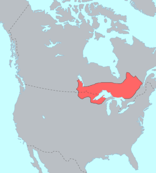
The Ojibwe, Ojibwa, Chippewa, or Saulteaux are an Anishinaabe people in what is currently southern Canada, the northern Midwestern United States, and Northern Plains. They are Indigenous peoples of the Subarctic and Northeastern Woodlands.

Chippewa is an alternate term for the Ojibwe tribe of North America.

Sandy Lake Band of Mississippi Chippewa are a historical Ojibwa tribe located in the upper Mississippi River basin, on and around Big Sandy Lake in what today is in Aitkin County, Minnesota. Though politically folded into the Mille Lacs Band of Ojibwe, thus no longer independently federally recognized, for decades, Sandy Lake Band members have been leading efforts to restore their independent Federal recognition.

Mille Lacs Indian Reservation is the popular name for the land-base for the Mille Lacs Band of Ojibwe in Central Minnesota, about 100 miles (160 km) north of Minneapolis-St. Paul. The contemporary Mille Lacs Band reservation has significant land holdings in Mille Lacs, Pine, Aitkin and Crow Wing counties, as well as other land holdings in Kanabec, Morrison, and Otter Tail Counties. Mille Lacs Indian Reservation is also the name of a formal Indian reservation established in 1855. It is one of the two formal reservations on which the contemporary Mille Lacs Band retains land holdings. The contemporary Mille Lacs band includes several aboriginal Ojibwe bands and villages, whose members reside in communities throughout central Minnesota.

<span class="mw-page-title-main">Mille Lacs Band of Ojibwe</span> Federally recognized American Indian tribe in east-central Minnesota

The Mille Lacs Band of Ojibwe, also known as the Mille Lacs Band of Chippewa Indians, is a federally recognized American Indian tribe in east-central Minnesota. The Band has 4,302 members as of 2012. Its homeland is the Mille Lacs Indian Reservation, consisting of District I, District II, District IIa, and District III.

The St. Croix Chippewa Indians are a historical Band of Ojibwe located along the St. Croix River, which forms the boundary between the U.S. states of Wisconsin and Minnesota. The majority of the St. Croix Band are divided into two groups: the federally recognized St. Croix Chippewa Indians of Wisconsin, and the St. Croix Chippewa Indians of Minnesota, who are one of four constituent members forming the federally recognized Mille Lacs Band of Ojibwe. The latter is one of six bands in the federally recognized Minnesota Chippewa Tribe.

<span class="mw-page-title-main">Lac Courte Oreilles Band of Lake Superior Chippewa Indians</span>

The Mille Lacs Indians, also known as the Mille Lacs and Snake River Band of Chippewa, are a Band of Indians formed from the unification of the Mille Lacs Band of Mississippi Chippewa (Ojibwe) with the Mille Lacs Band of Mdewakanton Sioux (Dakota). Today, their successor apparent Mille Lacs Band of Ojibwe consider themselves as being Ojibwe, but many on their main reservation have the ma'iingan (wolf) as their chief doodem (clan), which is an indicator of Dakota origins.

<span class="mw-page-title-main">Treaty of La Pointe</span> 1842 and 1854 treaties between the United States and Ojibwe

The Treaty of La Pointe may refer to either of two treaties made and signed in La Pointe, Wisconsin between the United States and the Ojibwe (Chippewa) Native American peoples. In addition, the Isle Royale Agreement, an adhesion to the first Treaty of La Pointe, was made at La Pointe.

Mississippi River Band of Chippewa Indians or simply the Mississippi Chippewa, are a historical Ojibwa Band inhabiting the headwaters of the Mississippi River and its tributaries in present-day Minnesota.

Pillager Band of Chippewa Indians are a historical band of Chippewa (Ojibwe) who settled at the headwaters of the Mississippi River in present-day Minnesota. Their name "Pillagers" is a translation of Makandwewininiwag, which literally means "Pillaging Men". The French called them Pilleurs, also a translation of their name. The French and Americans adopted their autonym for their military activities as the advance guard of the Ojibwe in the invasion of the Dakota country.

<span class="mw-page-title-main">Kechewaishke</span> Ojibwe leader

Chief Buffalo was a major Ojibwa leader, born at La Pointe in Lake Superior's Apostle Islands, in what is now northern Wisconsin, USA.

<span class="mw-page-title-main">Sandy Lake Tragedy</span> 1850 tragedy in Minnesota that led to the creation of Ojibwe reservations

The Sandy Lake Tragedy was the culmination in 1850 of a series of events centered in Big Sandy Lake, Minnesota that resulted in the deaths of several hundred Lake Superior Chippewa. Officials of the Zachary Taylor Administration and Minnesota Territory sought to relocate several bands of the tribe to areas west of the Mississippi River. By changing the location for fall annuity payments, the officials intended the Chippewa to stay at the new site for the winter, hoping to lower their resistance to relocation. Due to delayed and inadequate payments of annuities and lack of promised supplies, about 400 Ojibwe, mostly men and 12% of the tribe, died of disease, starvation and cold. The outrage increased Ojibwe resistance to removal. The bands effectively gained widespread public support to achieve permanent reservations in their traditional territories.

The Lake Superior Chippewa are a large number of Ojibwe (Anishinaabe) bands living around Lake Superior; this territory is considered part of northern Michigan, Wisconsin, and Minnesota in the United States. They migrated into the area by the seventeenth century, encroaching on the Eastern Dakota people who had historically occupied the area. The Ojibwe defeated the Eastern Dakota, who migrated west into the Great Plains after the final battle in 1745. While they share a common culture including the Anishinaabe language, this highly decentralized group of Ojibwe includes at least twelve independent bands in the region.

Lac Courte Oreilles is a large freshwater lake located in northwest Wisconsin in Sawyer County in townships 39 and 40 north, ranges 8 and 9 west. It is irregular in shape, having numerous peninsulas and bays, and is approximately six miles long in a southwest to northeast direction and with a maximum width of about two miles (3 km). Lac Courte Oreilles is 5,039 acres (20.39 km2) in size with a maximum depth of 90 feet (27 m) and a shoreline of 25.4 miles (40.9 km). The lake has a small inlet stream that enters on the northeast shore of the lake and flows from Grindstone Lake, a short distance away to the north. An outlet on the southeast shore of the lake leads through a very short passage to Little Lac Courte Oreilles, then via the Couderay River to the Chippewa River, and ultimately to the Mississippi River at Lake Pepin.

<span class="mw-page-title-main">Beautifying Bird</span> Ojibwe leader

Chief Beautifying Bird or Dressing Bird, (1794–1855) was a principal chief of the Prairie Rice Lake Band of the Lake Superior Chippewa, originally located near Rice Lake, Wisconsin. He served as the principal chief about the middle of the 19th century.

Treaty of St. Peters may be one of two treaties conducted between the United States and Native American peoples, conducted at the confluence of the Minnesota River with the Mississippi River, in what today is Mendota, Minnesota.

Sandy Lake is an unincorporated community Native American village located in Turner Township, Aitkin County, Minnesota, United States. Its name in the Ojibwe language is Gaa-mitaawangaagamaag, meaning "Place of the Sandy-shored Lake". The village is administrative center for the Sandy Lake Band of Mississippi Chippewa, though the administration of the Mille Lacs Indian Reservation, District II, is located in the nearby East Lake.

The Great Lakes Indian Fish & Wildlife Commission (GLIFWC) is an intertribal, co-management agency committed to the implementation of off-reservation treaty rights on behalf of its eleven-member Ojibwa tribes. Formed in 1984 and exercising authority specifically delegated by its member tribes, GLIFWC's mission is to help ensure significant off-reservation harvests while protecting the resources for generations to come.

An act for the relief and civilization of the Chippewa Indians in the State of Minnesota, commonly known as the Nelson Act of 1889, was a United States federal law intended to relocate all the Anishinaabe people in Minnesota to the White Earth Indian Reservation in the western part of the state, and expropriate the vacated reservations for sale to European settlers.

References

  1. "US Board on Geographic Names". United States Geological Survey. October 25, 2007. Retrieved January 31, 2008.

Further reading