
Duchesne County is a county in the northeast part of the U.S. state of Utah. As of the 2020 United States Census, the population was 19,596. Its county seat is Duchesne, and the largest city is Roosevelt.

Uintah County is a county in the U.S. state of Utah. As of the 2020 United States Census the population was 35,620. Its county seat and largest city is Vernal. The county was named for the portion of the Ute Indian tribe that lived in the basin.

Duchesne is a city in and the county seat of Duchesne County, Utah, United States. The population was 1,588 at the 2020 census.

Roosevelt is a city in Duchesne County, Utah, United States. The population was 6,046 at the 2010 census, with an estimated population of 7,070 in 2018.

Fort Duchesne is a census-designated place (CDP) in Uintah County, Utah, United States. The population was 714 at the 2010 census, an increase from the 2000 figure of 621.
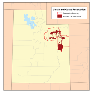
The Uintah and Ouray Indian Reservation is located in northeastern Utah, United States. It is the homeland of the Ute Indian Tribe, and is the largest of three Indian reservations inhabited by members of the Ute Tribe of Native Americans.

The Uinta Basin is a physiographic section of the larger Colorado Plateaus province, which in turn is part of the larger Intermontane Plateaus physiographic division. It is also a geologic structural basin in eastern Utah, east of the Wasatch Mountains and south of the Uinta Mountains. The Uinta Basin is fed by creeks and rivers flowing south from the Uinta Mountains. Many of the principal rivers flow into the Duchesne River which feeds the Green River—a tributary of the Colorado River. The Uinta Mountains forms the northern border of the Uinta Basin. They contain the highest point in Utah, Kings Peak, with a summit 13,528 feet above sea level. The climate of the Uinta Basin is semi-arid, with occasionally severe winter cold.
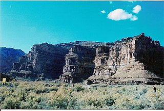
Ninemile Canyon is a canyon, approximately 40 miles (64 km) long, located in Carbon and Duchesne counties in eastern Utah, United States. Promoted as "the world's longest art gallery", the canyon is known for its extensive rock art, most of it created by the Fremont culture and the Ute people. The rock art, shelters, and granaries left behind by the Fremont make Ninemile Canyon a destination for archaeologists and tourists alike.

The west end of U.S. Route 40 (US-40) is in the U.S. state of Utah at Silver Creek Junction in Silver Summit with Interstate 80. From there it heads southeast through Heber City and east into Colorado on its way to the Mid-Atlantic.

The Dinosaur Diamond is a 486-mile (782 km) scenic and historic byway loop through the dinosaur fossil laden Uinta Basin of the U.S. states of Utah and Colorado. The byway comprises the following two National Scenic Byways:

Desolation Canyon is a remote canyon on the Green River in eastern Utah, United States that is listed on the National Register of Historic Places (NRHP). It is said to be one of the most remote areas in the contiguous United States.
State Route 88 (SR-88) is a state highway in the U.S. state of Utah, connecting Ouray to US-40/US-191.
Strawberry is an unincorporated community in western Duchesne County, Utah, United States. Most of the inhabitants live along the Strawberry River between the Strawberry River pinnacles and Starvation Reservoir west of the city of Duchesne, the county seat of Duchesne County.
The Strawberry River is an 18-mile (29 km) river located in eastern Utah, United States.
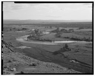
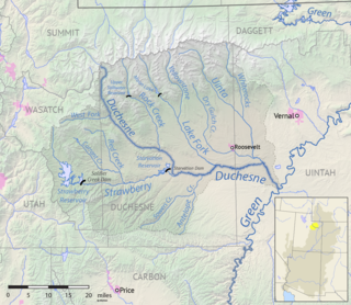
The Duchesne River, located in the Uintah Basin region of Utah in the western United States, is a tributary of the Green River. The watershed of the river covers the Northeastern corner of Utah. The Duchesne River is 115 miles (185 km) long, and drains a total land area of 3,790 square miles (9,800 km2).
Dragon is a ghost town in Uintah County, at the extreme eastern edge of Utah, United States. Founded in about 1888 as a Gilsonite mining camp, Dragon boomed in the first decade of the 20th century as the end-of-line town for the Uintah Railway. Although it declined when the terminus moved farther north in 1911, Dragon survived as the largest of the Gilsonite towns. It was abandoned after its mining operations stopped in 1938 and the Uintah Railway went out of business in 1939.
Ouray is an unincorporated village of the Uintah and Ouray Indian Reservation, located in west‑central Uintah County, Utah, United States.
The Uinta Basin Rail project is a proposed 100-mile (160 km) rail line to connect the shale oil rich Uinta Basin region of eastern Utah to the national rail network. Numerous proposals have been made, some as far back as 1902, that are still under consideration. The current effort is a public-private partnership between a coalition of 7 counties in Utah, the Rio Grande Pacific Corporation and Drexel Hamilton Infrastructure Partners. The railroad is also backed by the Ute Tribe who hold a 5% stake in the project. If the rail line is built it will be the first major greenfield rail line built in the United States since the line to the Powder River Basin was built in the 1970s. The Surface Transportation Board approved construction of the line in December 2021.
Ioka is an unincorporated community in eastern Duchesne County, Utah, United States.


