Hart, Texas | |
---|---|
Coordinates: 34°23′12″N102°6′54″W / 34.38667°N 102.11500°W | |
Country | United States |
State | Texas |
County | Castro |
Government | |
• Mayor | Eliazar Castillo [1] |
Area | |
• Total | 0.74 sq mi (1.92 km2) |
• Land | 0.74 sq mi (1.91 km2) |
• Water | 0.00 sq mi (0.01 km2) |
Elevation | 3,671 ft (1,119 m) |
Population | |
• Total | 869 |
• Density | 1,174.32/sq mi (454.97/km2) |
Time zone | UTC-6 (Central (CST)) |
• Summer (DST) | UTC-5 (CDT) |
ZIP code | 79043 |
Area code | 806 |
FIPS code | 48-32576 [4] |
GNIS feature ID | 1358866 [5] |
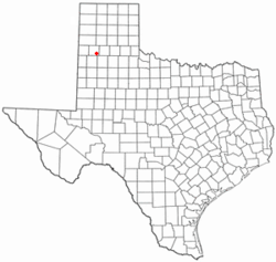
Hart is a city in Castro County, Texas, United States. The population was 869 at the 2020 census.
Hart, Texas is named after T. W. Hart, who established his ranch headquarters in the area. [6]
Hart became an organized town in 1925 after the Fort Worth and Denver South Plains Railway announced plans to establish a depot at the site. By 1926, the railway was completed, and a depot, was built. This led to the incorporation of Hart. In 1928, the business district was moved closer to the depot, and a six-room school was constructed. [6]
Hart is located in southeastern Castro County at 34°23′12″N102°6′54″W / 34.38667°N 102.11500°W (34.386723, –102.115035), [7] along Texas State Highway 194. Dimmitt, the county seat, is 16 miles (26 km) to the northwest, and Plainview is 28 miles (45 km) to the southeast.
According to the United States Census Bureau, Hart has a total area of 0.73 square miles (1.9 km2), all land. [8]
Census | Pop. | Note | %± |
---|---|---|---|
1960 | 577 | — | |
1970 | 905 | 56.8% | |
1980 | 1,008 | 11.4% | |
1990 | 1,221 | 21.1% | |
2000 | 1,198 | −1.9% | |
2010 | 1,114 | −7.0% | |
2020 | 869 | −22.0% | |
U.S. Decennial Census [9] |
Race | Number | Percentage |
---|---|---|
White (NH) | 115 | 13.23% |
Black or African American (NH) | 6 | 0.69% |
Native American or Alaska Native (NH) | 1 | 0.12% |
Mixed/Multi-Racial (NH) | 6 | 0.69% |
Hispanic or Latino | 741 | 85.27% |
Total | 869 |
As of the 2020 United States census, there were 869 people, 313 households, and 249 families residing in the city.
As of the census [4] of 2000, there were 1,198 people, 371 households, and 304 families residing in the city. The population density was 1,594.5 inhabitants per square mile (615.6/km2). There were 410 housing units at an average density of 545.7 per square mile (210.7/km2). The racial makeup of the city was 60.93% White, 3.09% African American, 0.92% Native American, 0.08% Pacific Islander, 32.05% from other races, and 2.92% from two or more races. Hispanic or Latino of any race were 74.62% of the population.
There were 371 households, out of which 48.8% had children under the age of 18 living with them, 68.2% were married couples living together, 8.4% had a female householder with no husband present, and 17.8% were non-families. 15.9% of all households were made up of individuals, and 8.4% had someone living alone who was 65 years of age or older. The average household size was 3.23 and the average family size was 3.61.
In the city, the population was spread out, with 35.9% under the age of 18, 10.0% from 18 to 24, 25.0% from 25 to 44, 18.9% from 45 to 64, and 10.2% who were 65 years of age or older. The median age was 28 years. For every 100 females, there were 104.1 males. For every 100 females age 18 and over, there were 99.0 males.
The median income for a household in the city was $28,424, and the median income for a family was $28,681. Males had a median income of $23,594 versus $15,625 for females. The per capita income for the city was $9,960. About 14.7% of families and 17.1% of the population were below the poverty line, including 20.5% of those under age 18 and 21.1% of those age 65 or over.
The city of Hart is served by the Hart Independent School District.
According to the Köppen Climate Classification system, Hart has a semi-arid climate, abbreviated "BSk" on climate maps. [13]
Climate data for Hart, Texas (1991–2020 normals, extremes 1986–present) | |||||||||||||
---|---|---|---|---|---|---|---|---|---|---|---|---|---|
Month | Jan | Feb | Mar | Apr | May | Jun | Jul | Aug | Sep | Oct | Nov | Dec | Year |
Record high °F (°C) | 81 (27) | 86 (30) | 91 (33) | 102 (39) | 108 (42) | 110 (43) | 106 (41) | 104 (40) | 107 (42) | 98 (37) | 91 (33) | 80 (27) | 110 (43) |
Mean maximum °F (°C) | 72.6 (22.6) | 77.1 (25.1) | 84.3 (29.1) | 89.7 (32.1) | 96.2 (35.7) | 100.5 (38.1) | 98.9 (37.2) | 97.4 (36.3) | 95.1 (35.1) | 90.1 (32.3) | 80.5 (26.9) | 72.6 (22.6) | 102.5 (39.2) |
Mean daily maximum °F (°C) | 50.8 (10.4) | 55.3 (12.9) | 63.4 (17.4) | 71.6 (22.0) | 79.6 (26.4) | 87.5 (30.8) | 89.2 (31.8) | 87.8 (31.0) | 81.4 (27.4) | 72.2 (22.3) | 60.3 (15.7) | 51.1 (10.6) | 70.8 (21.6) |
Daily mean °F (°C) | 35.7 (2.1) | 39.3 (4.1) | 47.1 (8.4) | 54.9 (12.7) | 64.5 (18.1) | 73.2 (22.9) | 75.7 (24.3) | 74.3 (23.5) | 67.5 (19.7) | 56.8 (13.8) | 44.9 (7.2) | 36.6 (2.6) | 55.9 (13.3) |
Mean daily minimum °F (°C) | 20.5 (−6.4) | 23.3 (−4.8) | 30.8 (−0.7) | 38.3 (3.5) | 49.3 (9.6) | 59.0 (15.0) | 62.2 (16.8) | 60.8 (16.0) | 53.6 (12.0) | 41.4 (5.2) | 29.5 (−1.4) | 22.1 (−5.5) | 40.9 (4.9) |
Mean minimum °F (°C) | 8.4 (−13.1) | 10.9 (−11.7) | 17.1 (−8.3) | 26.3 (−3.2) | 37.2 (2.9) | 51.2 (10.7) | 58.1 (14.5) | 55.6 (13.1) | 42.8 (6.0) | 27.6 (−2.4) | 15.3 (−9.3) | 8.8 (−12.9) | 3.7 (−15.7) |
Record low °F (°C) | −9 (−23) | −11 (−24) | 3 (−16) | 20 (−7) | 24 (−4) | 44 (7) | 52 (11) | 48 (9) | 33 (1) | 14 (−10) | −2 (−19) | −11 (−24) | −11 (−24) |
Average precipitation inches (mm) | 0.49 (12) | 0.49 (12) | 0.99 (25) | 1.18 (30) | 2.46 (62) | 2.56 (65) | 2.13 (54) | 2.35 (60) | 1.91 (49) | 1.64 (42) | 0.82 (21) | 0.72 (18) | 17.74 (451) |
Average snowfall inches (cm) | 1.2 (3.0) | 1.8 (4.6) | 0.6 (1.5) | 0.0 (0.0) | 0.0 (0.0) | 0.0 (0.0) | 0.0 (0.0) | 0.0 (0.0) | 0.0 (0.0) | 0.1 (0.25) | 0.7 (1.8) | 1.8 (4.6) | 6.2 (16) |
Average precipitation days (≥ 0.01 in) | 2.9 | 3.4 | 4.5 | 4.4 | 6.4 | 7.2 | 5.9 | 7.0 | 5.8 | 4.7 | 3.3 | 3.0 | 58.5 |
Average snowy days (≥ 0.1 in) | 0.7 | 1.0 | 0.4 | 0.1 | 0.0 | 0.0 | 0.0 | 0.0 | 0.0 | 0.1 | 0.5 | 1.0 | 3.8 |
Source: NOAA [14] [15] |
A rare type of meteorite unique to the Western Hemisphere was discovered near Hart in March 2010. A field worker found a single, large, dense brownish stone weighing 966 grams beside a road located 0.25 miles from the town of Hart. The meteor was subsequently purchased by a collector. The stone was analyzed at the University of Washington and was classified as a Carbonaceous Chondrite (CK3), the most massive example of one of 25 known specimens in the world. The finding was published in The Meteoritical Bulletin, No. 101 (2013) MB 101 with the meteorite being given the official name of "Hart". [16]
Castro County is a county located in the U.S. state of Texas. As of the 2020 census, its population was 7,371. Its county seat is Dimmitt. The county was named for Henri Castro, who was consul general to France for the Republic of Texas and the founder of a colony in Texas.
Jourdanton is a city in and the county seat of Atascosa County, Texas, United States. The population is 4,094. It is part of the San Antonio metropolitan statistical area. The mayor is Robert "Doc" Williams. The city manager is Bobby J. Martinez. The police chief is Eric Kaiser. The fire chief is Jay Fojtik.
Meridian is a city and the county seat of Bosque County in central Texas, United States. It is forty-seven miles northwest of Waco. The population was 1,493 at the 2010 census.
Caldwell is a city in and the county seat of Burleson County, Texas, United States. The population was 3,993 at the 2020 census. It is part of the Bryan-College Station metropolitan area.
Baird is a city and the county seat of Callahan County, Texas, United States. Its population was 1,496 at the 2010 census. The city is named after Matthew Baird, the owner and director of the Texas and Pacific Railway. The railway depot is now operated as the visitor center and a transportation museum.
Dimmitt is a city and county seat in Castro County, Texas, United States. Its population was 4,393 at the 2010 census.
Coleman is a town in and the county seat of Coleman County, Texas, United States. As of the 2010 census, its population was 4,709.
Crane is a city in and the county seat of Crane County, Texas, United States. Its population is about 3,680 as of 2018. An oil boomtown since the 1920s, Crane is still in the center of a prominent oil-producing region. It is the only significant town in sparsely populated Crane County, and contains the only post office in the county.
Dickens is a city in and the county seat of Dickens County, Texas, United States. The population was 286 at the 2010 census, down from 332 at the 2000 census.
Pearsall is a city in and the county seat of Frio County, Texas, United States. The population was 9,146 at the 2010 census, up from 7,157 at the 2000 census.
Haskell is a city in central Haskell County, Texas, United States. As of the 2010 census, the city population was 3,322. It is the Haskell county seat.
Encinal is a city in La Salle County, Texas, United States. The population was 540 at the 2020 census. Interstate 35 Business runs through the community. There are few businesses in Encinal; most have closed along the main street.
Olton is a city in Lamb County, Texas, United States. The population was 2,215 at the 2010 census.
Kempner is a city in Lampasas County, Texas, United States. The population was 1,146 at the 2020 census. It is part of the Killeen–Temple–Fort Hood Metropolitan Statistical Area.
Natalia is a city in Medina County, Texas, United States. The population was 1,202 at the 2020 census. It was founded in 1912 and was named after Natalie Pearson Nicholson, daughter of Frederick Stark Pearson, engineer, designer and builder of the Medina Dam.
Vega is a city and county seat of Oldham County, Texas, United States. The population was 884 at the 2010 census, down from 936 at the 2000 census.
Friona is a city in Parmer County, Texas, United States. The population was 4,123 at the 2010 census. Friona was established as a small community in 1898 by XIT Ranch, originally called Frio, which is also the word for "cold" in Spanish.
Grandfalls is a town in Ward County, Texas, United States. It was named for its location near the "grand falls" of the Pecos River, located roughly 3 miles (4.8 km) to the west. Early settlers were attracted to the Grandfalls area in the late 1880s by the steady supply of water flowing in the Pecos River. Its population was 360 at the 2010 census.
Plains is a town and the county seat of Yoakum County of western Texas, United States, particularly the south (inner) half of the panhandle's plains. The city's population was 1,481 at the 2010 census. Plains is in the Texas High Plains Wine country.
Ackerly is a city in Dawson and Martin Counties in the U.S. state of Texas. As of the 2020 Census, the population was 264. The Martin county portion of Ackerly is part of the Midland-Odessa metropolitan area.