West Yorkshire is a metropolitan and ceremonial county in the Yorkshire and the Humber region of England. It borders North Yorkshire to the north and east, South Yorkshire and Derbyshire to the south, Greater Manchester to the south-west, and Lancashire to the west. The city of Leeds is the largest settlement.

Brighouse is a town within the metropolitan borough of Calderdale, in West Yorkshire, England. Historically within the West Riding of Yorkshire, it is situated on the River Calder, 4 miles (6.4 km) east of Halifax. It is served by Junction 25 of the M62 motorway and Brighouse railway station on the Caldervale Line and Huddersfield Line. In the town centre is a mooring basin on the Calder and Hebble Navigation. The United Kingdom Census 2001 gave the Brighouse / Rastrick subdivision of the West Yorkshire Urban Area a population of 32,360. The Brighouse ward of Calderdale Council gave a population of 11,195 at the 2011 Census. Brighouse has a HD6 postcode.

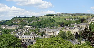
Mytholmroyd is a large village and former civil parish, now in the parish of Hebden Royd, in the Calderdale district, in West Yorkshire, England, 2 miles (3 km) east of Hebden Bridge. It lies in the Upper Calder Valley, 10 miles (16 km) east of Burnley and 7 miles (11 km) west of Halifax. The village, which has a population of approximately 4,000, is in the Luddendenfoot Ward of Calderdale Council.

Heptonstall is a small village and civil parish within the Calderdale borough of West Yorkshire, England, historically part of the West Riding of Yorkshire. The population of Heptonstall, including the hamlets of Colden and Slack, is 1,448, increasing to 1,470 at the 2011 Census. The town of Hebden Bridge lies directly to the south-east. Although Heptonstall is part of Hebden Bridge as a post town, it is not within the Hebden Royd town boundaries.
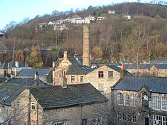
Hebden Bridge is a market town in the Calderdale district of West Yorkshire, England. It is in the Upper Calder Valley, 8 miles (13 km) west of Halifax and 14 miles (21 km) north-east of Rochdale, at the confluence of the River Calder and the Hebden Water. The town is the largest settlement in the civil parish of Hebden Royd.

Todmorden is a market town and civil parish in the Upper Calder Valley in Calderdale, West Yorkshire, England. It is 17 miles north-east of Manchester, 8 miles (13 km) south-east of Burnley and 9 miles (14 km) west of Halifax. In 2011, it had a population of 15,481.

Calderdale is a metropolitan borough of West Yorkshire, England, which had a population of 211,439. It takes its name from the River Calder, and dale, a word for valley. The name Calderdale usually refers to the borough through which the upper river flows, while the actual landform is known as the Calder Valley. Several small valleys contain tributaries of the River Calder. The main towns of the borough are Brighouse, Elland, Halifax, Hebden Bridge, Sowerby Bridge and Todmorden.

Cragg Vale is a village in Calderdale, West Yorkshire, England, located south of Mytholmroyd on the B6138 road which joins the A58 and the A646. The village is part of Luddendenfoot Ward of Calderdale Council.

The Calder Valley line is a railway route in Northern England between the cities of Leeds and Manchester as well as the seaside resort of Blackpool. It is the slower of the two main rail routes between Leeds and Manchester, and the northernmost of the three main trans-Pennine routes.

Hebden Bridge railway station serves the town of Hebden Bridge in West Yorkshire, England. The station is on the Calder Valley Line, operated by Northern since April 2016, from York and Leeds towards Manchester Victoria and Preston. The station is 8.5 miles (14 km) west of Halifax and 26 miles (42 km) west of Leeds.
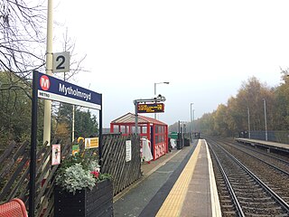
Mytholmroyd railway station serves the communities of Mytholmroyd, Luddendenfoot, Midgley, Cragg Vale, and surrounding areas in West Yorkshire, England. It has disabled access via ramps instead of steps on both platforms, unusually as the station is built on a viaduct. It lies on the Calder Valley Line operated by Northern and is situated 7.5 miles (12 km) west of Halifax and 25 miles (40 km) west of Leeds.
Luddendenfoot or Luddenden Foot is a village in West Yorkshire, England. It is in the borough of Calderdale, to the northwest of Sowerby Bridge and west of Halifax. The population of Luddendenfoot is 2,547, with the wider Calderdale Ward having a population of 10,653 at the 2011 Census. The village lies along the Upper Calder Valley below Luddenden, between Sowerby Bridge and Mytholmroyd.

Sowerby was a county constituency centred on the village of Sowerby in Calderdale, West Yorkshire. It returned one Member of Parliament (MP) to the House of Commons of the Parliament of the United Kingdom.

The Upper Calder Valley lies in West Yorkshire, in northern England, and covers the towns of Todmorden, Hebden Bridge, Mytholmroyd, Luddendenfoot, and Sowerby Bridge, as well as a number of smaller settlements such as Portsmouth, Cornholme, Walsden, and Eastwood. The valley is the upper valley of the River Calder. Major tributaries of the Upper Calder include the Walsden Water, which flows through the large village of Walsden to join the Calder at Todmorden; the Hebden Water, which flows through Hebden Dale to join the Calder at Hebden Bridge; Cragg Brook, which flows through Cragg Vale to join the Calder at Mytholmroyd, and the largest, the River Ryburn, which joins the Calder at Sowerby Bridge.

Eastwood is a place within the civil parish of Todmorden and Metropolitan Borough of Calderdale, in West Yorkshire, England. It lies 8 miles (12.9 km) west from Halifax, roughly equidistant from Todmorden's town centre, which is 2 miles (3.2 km) to the southwest, and Hebden Bridge, which is 2 miles to the northeast, along the course of the River Calder. Eastwood falls within the Calder ward of Calderdale council.

Mons Mill, Todmorden, is a former cotton spinning mill in Todmorden, Calderdale, West Yorkshire, England built for the Hare Spinning Company Limited. It was built in 1907, but ran into financial difficulties. It passed over to the Mons Mill (1919) Co Ltd and then was taken over by the Lancashire Cotton Corporation in 1930 and passed to Courtaulds in 1964 and production stopped in 1968. It was used into the 1990s by Ward & Goldstone Ltd. The site was cleared in 2000.

The River Calder is a river in West Yorkshire, in Northern England.

Calderdale Metropolitan Borough Council, also known as Calderdale Council, is the local authority for the Metropolitan Borough of Calderdale in West Yorkshire, England. It is a metropolitan borough council and provides the majority of local government services in the borough. Since 2014 the council has been a constituent member of the West Yorkshire Combined Authority.
Hebden Royd is a civil parish in the metropolitan borough of Calderdale, West Yorkshire, England. It contains 254 listed buildings that are recorded in the National Heritage List for England. Of these, twelve are at Grade II*, the middle of the three grades, and the others are at Grade II, the lowest grade. The parish contains the market town of Hebden Bridge, the large village of Mytholmroyd, the valley to the south of Mytholmroyd which contains the village of Cragg Vale, and the surrounding area.