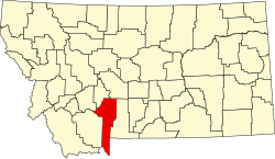
Hebgen Lake Estates, Montana

Last updated
Hebgen Lake Estates, Montana
USA Montana location map.svg
Red pog.svg
Hebgen Lake Estates
Usa edcp location map.svg
Red pog.svg
Hebgen Lake Estates
Coordinates: 44°46′9″N111°11′26″W / 44.76917°N 111.19056°W / 44.76917; -111.19056 Coordinates: 44°46′9″N111°11′26″W / 44.76917°N 111.19056°W / 44.76917; -111.19056
Country United States
State Montana
County Gallatin
Area
[1]
  Total0.18 sq mi (0.48 km2)
  Land0.18 sq mi (0.48 km2)
  Water0.00 sq mi (0.00 km2)
Elevation
6,565 ft (2,001 m)
Population
 (2020)
  Total123
  Density668.48/sq mi (257.73/km2)
Time zone UTC-7 (Mountain (MST))
  Summer (DST) UTC-6 (MDT)
Area code 406
FIPS code 30-35435
GNIS feature ID2583814 [2]

Hebgen Lake Estates is a census-designated place (CDP) in Gallatin County, Montana, United States. The population was 70 at the 2010 census. [3] It is next to Hebgen Lake.

Demographics

Historical population
CensusPop.
2020 123
U.S. Decennial Census [4]

Related Research Articles

<span class="mw-page-title-main">Sheridan County, Montana</span> County in Montana, United States

Sheridan County is a county in the U.S. state of Montana. As of the 2020 census, the population was 3,539. Its county seat is Plentywood. Its northern boundary is the Canada–United States border south of Saskatchewan.

<span class="mw-page-title-main">Powell County, Montana</span> County in Montana, United States

Powell County is a county in the U.S. state of Montana. As of the 2020 census, the population was 6,946. Its county seat is Deer Lodge.

<span class="mw-page-title-main">Lake County, Montana</span> County in Montana, United States

Lake County is a county located in the northwest part of the U.S. state of Montana. As of the 2020 census, the population was 31,134. Its county seat is Polson.

<span class="mw-page-title-main">Gallatin County, Montana</span> County in Montana, United States

Gallatin County is located in the U.S. state of Montana. With its county seat in Bozeman, it is the second-most populous county in Montana, with a population of 118,960 in the 2020 Census.

<span class="mw-page-title-main">Flathead County, Montana</span> County in Montana, United States

Flathead County is in the U.S. state of Montana. At the 2020 census, its population was 104,357, making it the state's fourth most populous county. Its county seat is Kalispell. Its numerical designation is 7. Its northern border is on the state's north border, making it contiguous with the Canada–US border, facing British Columbia.

<span class="mw-page-title-main">Broadwater County, Montana</span> County in Montana, United States

Broadwater County is a county in the U.S. state of Montana. As of the 2020 census, the population was 6,774. Its county seat is Townsend. The county was named for Charles Arthur Broadwater, a noted Montana railroad, real estate, and banking magnate.

<span class="mw-page-title-main">Bigfork, Montana</span> Unincorporated community in Montana, United States

Bigfork is a census-designated place (CDP) in Flathead County, Montana, United States. It is within Montana's Rocky Mountains. The population was 4,270 at the 2010 census, up from 1,421 in 2000.

<span class="mw-page-title-main">Kalispell, Montana</span> City in Montana, United States

Kalispell is a city in, and the county seat of, Flathead County, Montana, United States. The 2020 census put Kalispell's population at 24,558. In Montana's northwest region, it is the largest city, and the commercial center, of the Kalispell Micropolitan Statistical Area. The name Kalispell is a Salish word meaning "flat land above the lake".

<span class="mw-page-title-main">Big Arm, Montana</span> Census-designated place in Montana, United States

Big Arm is a census-designated place (CDP) in Lake County, Montana, United States. The population was 177 at the 2010 census, up from 131 in 2000.

<span class="mw-page-title-main">Elmo, Montana</span> Census-designated place in Montana, United States

Elmo is a census-designated place (CDP) in Lake County, Montana, United States. The population was 180 at the 2010 census, up from 143 in 2000.

<span class="mw-page-title-main">Woods Bay, Montana</span> Census-designated place in Montana, United States

Woods Bay is a census-designated place (CDP) in Lake County, Montana, United States. The population was 661 at the 2010 census, down from 748 at the 2000 census.

<span class="mw-page-title-main">Polson, Montana</span> Town in Montana, United States

Polson is a city in Lake County, Montana, United States, on the southern shore of Flathead Lake. It is also on the Flathead Indian Reservation. The population was 5,148 at the 2020 census. It is the county seat of Lake County. In 1898 the city was named after pioneer rancher David Polson. It was incorporated in 1910.

<span class="mw-page-title-main">Quake Lake</span> Lake in southwestern Montana, United States

Quake Lake is a lake in the western United States, on the Madison River in southwestern Montana. It was created after an earthquake struck on August 17, 1959, with 28 fatalities. Northwest of West Yellowstone, Quake Lake is six miles (10 km) in length with a maximum depth of 125 feet (38 m).

<span class="mw-page-title-main">Hebgen Lake</span> Lake in Gallatin County, Montana

Hebgen Lake is a reservoir created by the Hebgen Dam, located in Gallatin County in southwest Montana. It is well known for the 1959 Hebgen Lake earthquake which occurred nearby on August 17, 1959, forming Quake Lake, which is located immediately downstream.

The 1959 Hebgen Lake earthquake occurred in the western United States on August 17 at 11:37 pm (MST) in southwestern Montana.

Swan Lake is a census-designated place and unincorporated community in Lake County, Montana, United States. Its population was 113 as of the 2010 census.

Lake Mary Ronan is a census-designated place (CDP) in Lake County, Montana, United States. The population was 65 at the 2010 census. The CDP is in northwestern Lake County, along the northern and eastern shores of Lake Mary Ronan, and includes the populated places of Lake Mary Ronan, Melton, and Sipes, as well as Lake Mary Ronan State Park. It is 8 miles (13 km) northwest of U.S. Route 93 at Dayton, and 30 miles (48 km) northwest of Polson, the Lake county seat.

Little Bitterroot Lake is a census-designated place (CDP) in Flathead County, Montana, United States. The population was 194 at the 2010 census. The town is next to Little Bitterroot Lake.

West Kootenai is a census-designated place (CDP) in Lincoln County, Montana, United States. The population was 365 at the 2010 census.

References

  1. "ArcGIS REST Services Directory". United States Census Bureau. Retrieved September 5, 2022.
  2. U.S. Geological Survey Geographic Names Information System: Hebgen Lake Estates, Montana
  3. "U.S. Census website". United States Census Bureau . Retrieved 2011-05-14.
  4. "Census of Population and Housing". Census.gov. Retrieved June 4, 2016.