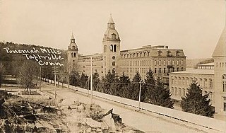
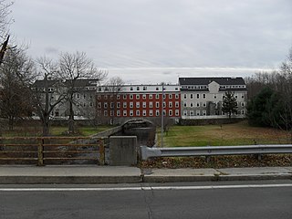
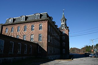
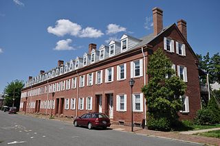
Taftville is a small village in eastern Connecticut. It is a neighborhood of Norwich but has its own post office. It was established in 1866 as site for the large Taftville Mill, later Ponemah Mill. The village is listed on the National Register of Historic Places as Taftville and as alternative name Taftville/Ponemah Mill National Register Historic District.

Cannelton Cotton Mill, also known as Indiana Cotton Mill, is a National Historic Landmark of the United States located in Cannelton, Indiana, United States. Built in 1849 as an effort to expand textile milling out of New England, it was the largest industrial building west of the Allegheny Mountains, designed by Thomas Alexander Tefft, an early industrial architect. It was declared a National Historic Landmark in 1991. The building now houses residences.

The Boston Manufacturing Company was a business that operated one of the first factories in America. It was organized in 1813 by Francis Cabot Lowell, a wealthy Boston merchant, in partnership with a group of investors later known as The Boston Associates, for the manufacture of cotton textiles. It built the first integrated spinning and weaving factory in the world at Waltham, Massachusetts, using water power. They used plans for a power loom that he smuggled out of England as well as trade secrets from the earlier horse-powered Beverly Cotton Manufactory, of Beverly, Massachusetts, of 1788. This was the largest factory in the U.S., with a workforce of about 300. It was a very efficient, highly profitable mill that, with the aid of the Tariff of 1816, competed effectively with British textiles at a time when many smaller operations were being forced out of business. While the Rhode Island System that followed was famously employed by Samuel Slater, the Boston Associates improved upon it with the "Waltham System". The idea was successfully copied at Lowell, Massachusetts, and elsewhere in New England. Many rural towns now had their own textile mills.

North Uxbridge is a village and a post office in the town (township) of Uxbridge in Worcester County, Massachusetts, United States. The postal zip code is 01538. It is classified as a community or populated place located at latitude 42.088 and longitude -71.641 and the elevation is 266 feet (81 m). North Uxbridge appears on the Uxbridge U.S. Geological Survey Map. Worcester County is in the Eastern time zone and observes DST. North Uxbridge is located about 36 miles WSW of Boston, and 15 miles SE of Worcester. The town meeting in 1885 set aside North Uxbridge as a "special district", since its population had exceeded 1000 people. North Uxbridge appeared to be a separate Census tract in the 1960 census with a population of 1882. In 2013, an Uxbridge DIY show, The Garage, with Steve Butler, went worldwide from Steve's garage in North Uxbridge.
Rogersons Village Historic District is a historic mill village in Uxbridge, Massachusetts, United States.
The Linwood Historic District is an industrial historic district in the Linwood village of Northbridge, Massachusetts. It is the site of the Linwood Cotton Mill and is roughly bounded by Linwood Avenue, Maple Court, and Pine Court. On June 16, 1989, it was added to the National Register of Historic Places.

Quinebaug Mill–Quebec Square Historic District is a historic district roughly bounded by the Quinebaug River, Quebec Square, and Elm and S. Main Streets in the town of Brooklyn in Windham County, Connecticut. The district encompasses a well-preserved 19th-century mill village. It was added to the National Register of Historic Places in 1985.

The Talcottville Historic District is a historic district in the town of Vernon, Connecticut. Centered on Elm Hill Road and Main Street, it encompasses a 19th-century mill village, including archaeological remnants of very early cotton-spinning facilities, an old stone dam, and a major wood-frame mill constructed by the Talcott brothers. Also included in the village are a significant number of mill worker housing units, many dating to the middle decades of the 19th century, and an 1891 lenticular pony truss bridge, built by the Berlin Iron Bridge Company. The district was listed on the National Register of Historic Places in 1989.

The Central Village Historic District is a historic district in the Central Village area of Plainfield, Connecticut that was listed on the National Register of Historic Places (NRHP) in 1991. It encompasses a late 19th-century historic mill village, including a small commercial center where Connecticut Route 12 and 14 meet, a cluster of architecturally distinguished buildings built by mill owners and managers, and a collection of mill worker housing units. It includes the Plainfield Woolen Company Mill, which is separately listed, as well as archaeological remnants of other mill infrastructure. It also includes Plainfield's old town hall and high school. Other architecturally prominent buildings include the c. 1855 Italianate mansion of mill owner Arthur Fenner, and the 1845 Greek Revival Congregational Church.

The Howland Mill Village Historic District is a historic district roughly bounded by Bolton, Winsper, Hemlock Sts., and Rockdale Avenue in New Bedford, Massachusetts. It consists of a collection of single-family mill worker housing units constructed in 1888-89 for workers at the nearby Howland Mill, and several double-decker houses built in the 1920s. The districts uniformity of style is apparent despite some exterior alterations: there are only two basic house plans. The Howland Mill Company was founded in 1886, and its mills were used in production until 1954. Most of the housing was sold off in the 1910s.
The Hadley Falls Company Housing District is a residential historic district encompassing a compact tract of factory worker housing in Holyoke, Massachusetts. Built in 1847-48, it is one of the earliest and largest surviving examples of company-built worker housing in the state. It includes five rowhouses facing Center, Lyman, Grover, and Canal Streets. The district was listed on the National Register of Historic Places in 1972.

The North Canal Historic District of Lawrence, Massachusetts, encompasses the historic industrial heart of the city. It is centered on the North Canal and the Great Stone Dam, which provided the waterpower for its many mill complexes. The canal was listed on the National Register of Historic Places in 1975, while the district was first listed in 1984, and then expanded slightly in 2009.

The Pleasant–High Historic District encompasses the earliest area of non-agricultural residential development in Methuen, Massachusetts. It encompasses houses along High and Pleasant Streets from just east of Broadway to Vine Street, as well as a few that face on adjoining streets. The district was listed on the National Register of Historic Places in 1984; on its western boundary it abuts the Spicket Falls Historic District.

The Forge Village Historic District of Westford, Massachusetts encompasses one of the town's historic 19th century mill villages. The focal point of the district is the mill complex of the Abbot Worsted Company, around which the village expanded after its founding in 1854. Prior to its founding the area was the site of a number of blacksmithies and iron forging operations, and was the site of a fulling mill in the 18th century. The center of the district is at the junction of East and West Prescott Streets with Pleasant Street, radiating away to ballfields on West Prescott, Abbot Street at Pleasant, and just beyond Orchard Street on East Prescott. Worker housing occupies a number of adjacent streets in the area.

The Hamilton Woolen Company Historic District encompasses the well preserved "Big Mill" complex of the Hamilton Woolen Company, built in the mid 19th century. Located at the confluence of McKinstry Brook and the Quinebaug River in central Southbridge, Massachusetts, the complex consists of a cluster of mill buildings and a rare collection of 1830s brick mill worker housing units located nearby. The district was listed on the National Register of Historic Places in 1989.

The Nashua Manufacturing Company Historic District in Nashua, New Hampshire, is a historic district that was listed on the National Register of Historic Places (NRHP) in 1987. It encompasses an area just west of downtown Nashua, roughly located along the southern bank of the Nashua River, bordered on the west side by Mine Falls Park, on the south side by the Nashua River canal, up to Ledge Street, and from the east side by Factory, Pine and Water streets, up to the Main Street bridge.
Bemis is a former company town in Madison County, Tennessee, United States, now part of the city of Jackson. The Bemis Brothers Bag Company established the town in 1900 to be the site of a cotton mill and housing for the mill workers. A 450-acre (180 ha) area of Bemis was added to the National Register of Historic Places in 1991 as the Bemis Historic District. Much of the area is also a local historic district.
The Lewiston Mills and Water Power System Historic District encompasses the major 19th-century mill complexes and associated water power systems in Lewiston, Maine. Developed beginning in 1850, Lewiston's canals and mills were the largest textile mill complex in the state, and one of the best-preserved mature large-scale expressions of the Lowell system of cotton textile manufacturing, perfected at Waltham and Lowell, Massachusetts earlier in the 19th century. The district includes a series power canals and mill complexes developed over a 100-year period, along with mill worker housing and transportation infrastructure. It was listed on the National Register of Historic Places in 2015.

The Manchaug Village Historic District is a historic district encompassing the 19th century industrial village center of Manchaug in Sutton, Massachusetts. Developed in the 1820s around textile mills on the Mumford River, it was the largest industrial area in Sutton, with at least three mill complexes in operation. The district is centered on the junction of Main Street with Manchaug, Putnam Hill, and Whitins Roads.


