Helens Hill, Queensland

Last updated

Helens Hill
Queensland
Australia Queensland location map.svg
Red pog.svg
Helens Hill
Coordinates 18°47′14″S146°07′30″E / 18.7873°S 146.125°E / -18.7873; 146.125 (Helens Hill (centre of locality))
Population118 (2021 census) [1]
 • Density0.956/km2 (2.477/sq mi)
Postcode(s) 4850
Area123.4 km2 (47.6 sq mi)
Time zone AEST (UTC+10:00)
LGA(s) Shire of Hinchinbrook
State electorate(s) Hinchinbrook
Federal division(s) Kennedy
Suburbs around Helens Hill:
Wharps Wharps Toobanna
Upper Stone Helens Hill Orient
Yuruga Yuruga Yuruga

Helens Hill is a rural locality in the Shire of Hinchinbrook, Queensland, Australia. [2] In the 2021 census, Helens Hill had a population of 118 people. [1]

Contents

Geography

Despite the name, Helens Hill is predominantly flat farming land (approx 20 metres above sea level), well-watered by numerous small creeks and is used for growing sugarcane. Mount Helen (also known as Helens Hill) rises to 227 metres (745 ft) in the locality ( 18°46′19″S146°09′06″E / 18.7719°S 146.1518°E / -18.7719; 146.1518 (Mount Helen (Helens Hill)) ) and presumably is the source of the locality's name. [3] [4] [5]

The Bruce Highway passes through the locality from the south-east to the north. [3]

The North Coast railway line passes through the locality from the south-east to the north with Pombel railway station ( 18°45′32″S146°09′17″E / 18.7590°S 146.1546°E / -18.7590; 146.1546 (Pombel railway station) ) serving the locality. [6] [7] Previously there were two other railway stations on the North Coast line within the locality, but both of these have been abandoned:

A cane tramway delivers harvested sugarcane to the local sugar mills at Victoria Plantation and Macknade. [3]

History

Helens Hill State School opened on 17 August 1931. [8] The school closed on 31 December 2016. [9] [10] It was located at 48388 Bruce Highway ( 18°46′08″S146°08′07″E / 18.7690°S 146.1352°E / -18.7690; 146.1352 (Helens Hill State School (former)) ). [11] [3] The school's website was archived. [12]

Demographics

In the 2016 census Helens Hill had a population of 123 people. [13]

In the 2021 census, Helens Hill had a population of 118 people. [1]

Related Research Articles

<span class="mw-page-title-main">Cardwell, Queensland</span> Town in Queensland, Australia

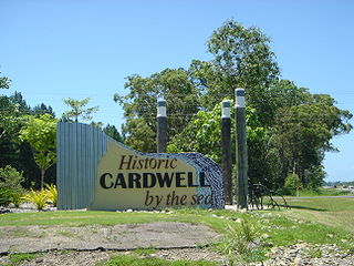
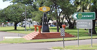
Cardwell is a coastal town and rural locality in the Cassowary Coast Region, Queensland, Australia. In the 2016 census, the locality of Cardwell had a population of 1,309 people.

<span class="mw-page-title-main">Ingham, Queensland</span> Town in Queensland, Australia

Ingham is a rural town and locality in the Shire of Hinchinbrook, Queensland, Australia. It is named after William Bairstow Ingham and is the administrative centre for the Shire of Hinchinbrook.

<span class="mw-page-title-main">Lucinda, Queensland</span> Town in Queensland, Australia

Lucinda is a coastal town and locality in the Shire of Hinchinbrook, Queensland, Australia. In the 2021 census, the locality of Lucinda had a population of 435 people.

The Dawn is a rural residential locality in the Gympie Region, Queensland, Australia. In the 2016 census The Dawn had a population of 545 people.

<span class="mw-page-title-main">Rollingstone, Queensland</span> Town in Queensland, Australia

Rollingstone is a rural town and coastal locality in the City of Townsville, Queensland, Australia. In the 2016 census, the locality of Rollingstone had a population of 125 people.

<span class="mw-page-title-main">Torrens Creek</span> Town in Queensland, Australia

Torrens Creek is a rural town and locality in the Shire of Flinders, Queensland, Australia. In the 2016 census the locality of Torrens Creek had a population of 70 people.

<span class="mw-page-title-main">Halifax, Queensland</span> Town in Queensland, Australia

Halifax is a town and a coastal locality in the Shire of Hinchinbrook, Queensland, Australia. In the 2021 census, the locality of Halifax had a population of 477 people.

<span class="mw-page-title-main">Abergowrie, Queensland</span> Suburb of Shire of Hinchinbrook, Queensland, Australia

Abergowrie is a rural town and locality in the Shire of Hinchinbrook, Queensland, Australia. In the 2021 census, the locality of Abergowrie had a population of 305 people.

Taylors Beach is a coastal town and locality in the Shire of Hinchinbrook, Queensland, Australia. It takes its name from its beach. In the 2016 census, the locality of Taylors Beach had a population of 318 people.

<span class="mw-page-title-main">Macknade, Queensland</span> Town in Queensland, Australia

Macknade is a rural town and coastal locality in the Shire of Hinchinbrook, Queensland, Australia. In the 2016 census, the locality of Macknade had a population of 229 people.

<span class="mw-page-title-main">Mount Chalmers, Queensland</span> Town in Queensland, Australia

Mount Chalmers is a rural town and locality in the Livingstone Shire, Queensland, Australia. In the 2016 census, the locality of Mount Chalmers had a population of 235 people.

<span class="mw-page-title-main">Sommariva, Queensland</span> Suburb of Shire of Murweh, Queensland, Australia

Sommariva is a locality in the Shire of Murweh, Queensland, Australia. It is situated 37.9 kilometres (23.5 mi) east of Charleville and 57.4 kilometres (35.7 mi) west of Morven on the Warrego Highway. In the 2021 census, Sommariva had a population of 25 people.

Bambaroo is a rural locality in the Shire of Hinchinbrook, Queensland, Australia. In the 2021 census, Bambaroo had a population of 146 people.

Foresthome is a rural locality in the Shire of Hinchinbrook, Queensland, Australia. In the 2021 census, Foresthome had a population of 84 people.

<span class="mw-page-title-main">Bemerside, Queensland</span> Suburb of Shire of Hinchinbrook, Queensland, Australia

Bemerside is a rural locality in the Shire of Hinchinbrook, Queensland, Australia. In the 2021 census, Bemerside had a population of 259 people.

<span class="mw-page-title-main">Mulgrave, Queensland</span> Suburb of Shire of Burdekin, Queensland, Australia

Mulgrave is a rural locality in the Shire of Burdekin, Queensland, Australia. In the 2021 census, Mulgrave had a population of 19 people.

Ward is a rural locality in the Shire of Murweh, Queensland, Australia. In the 2016 census Ward had a population of 74 people.

Rungoo is a coastal locality in the Cassowary Coast Region, Queensland, Australia. In the 2021 census, Rungoo had a population of 11 people.

<span class="mw-page-title-main">Hawkins Creek, Queensland</span> Suburb of Shire of Hinchinbrook, Queensland, Australia

Hawkins Creek is a rural locality in the Shire of Hinchinbrook, Queensland, Australia. In the 2021 census, Hawkins Creek had a population of 236 people.

Goondi Hill is a semi-urban locality in the Cassowary Coast Region, Queensland, Australia. In the 2021 census, Goondi Hill had a population of 437 people.

References

  1. 1 2 3 Australian Bureau of Statistics (28 June 2022). "Helens Hill (SAL)". 2021 Census QuickStats. Retrieved 28 February 2023. OOjs UI icon edit-ltr-progressive.svg
  2. "Helens Hill – locality in Shire of Hinchinbrook (entry 42519)". Queensland Place Names. Queensland Government . Retrieved 27 December 2020.
  3. 1 2 3 4 "Queensland Globe". State of Queensland . Retrieved 2 January 2021.
  4. "Mountain peaks and capes - Queensland". Queensland Open Data. Queensland Government. 12 November 2020. Archived from the original on 25 November 2020. Retrieved 25 November 2020.
  5. "Mount Helen – mountain in Hinchinbrook Shire (entry 15661)". Queensland Place Names. Queensland Government . Retrieved 25 November 2020.
  6. "Pombel – railway station in Hinchinbrook Shire (entry 27274)". Queensland Place Names. Queensland Government . Retrieved 4 October 2017.
  7. 1 2 3 "Railway stations and sidings - Queensland". Queensland Open Data. Queensland Government. 2 October 2020. Archived from the original on 5 October 2020. Retrieved 5 October 2020.
  8. Queensland Family History Society (2010), Queensland schools past and present (Version 1.01 ed.), Queensland Family History Society, ISBN   978-1-921171-26-0
  9. "School Openings, Closures & Name Changes - Recent Events". Opening and closing dates of Queensland schools. Queensland Government. Archived from the original on 4 October 2017. Retrieved 4 October 2017.
  10. "Helens Hill State School". Archived from the original on 27 July 2012. Retrieved 2 January 2021.
  11. "Parish of Trebonne Sheet 2" (Map). Queensland Government. 1978. Archived from the original on 2 January 2021. Retrieved 2 January 2021.
  12. "Helens Hill State School". Helens Hill State School. 27 July 2012. Archived from the original on 27 July 2012. Retrieved 16 August 2023.
  13. Australian Bureau of Statistics (27 June 2017). "Helens Hill (SSC)". 2016 Census QuickStats. Retrieved 20 October 2018. OOjs UI icon edit-ltr-progressive.svg

Further reading

Commons-logo.svg Media related to Helens Hill, Queensland at Wikimedia Commons