Related Research Articles
Hensbarrow Beacon is a hill in Cornwall, England, United Kingdom. It is situated a mile north-west of Stenalees village at grid reference SW 996 575. It is the highest natural point of the Hensbarrow uplands, a natural region and national character area.

The River Inny is a small river in east Cornwall, United Kingdom. It is a tributary of the River Tamar and is about twenty miles (32 km) long from its source near Davidstow on the eastern flank of Bodmin Moor to its confluence with the Tamar at Inny Foot near Dunterton.

The River Allen in north Cornwall is one of two rivers of the same name in Cornwall which share this name. In this case the name is the result of a mistake made in 1888 by Ordnance Survey, replacing the name Layne with Allen which is the old name for the lower reaches of the Camel. The other River Allen runs through Truro.

The De Lank River is a small river in north Cornwall, England. It is a tributary of the River Camel and is approximately nine miles (14.5 km) long from its source on Bodmin Moor to its confluence with the Camel two miles (3 km) south of St Breward.

St Austell Bay is a bay on Cornwall's south coast which is bounded to the east by Gribbin Head and to the west by Black Head.

Churchbridge is a hamlet in Cornwall, England. It is a mile west of Duloe, and is situated on the West Looe River. Both banks of the river are wooded, and to the north of the bridge is a disused quarry and Tremadart Mills, marked as a corn mill on the 1882 map.

Connon is a hamlet near Liskeard in Cornwall, England. Connon is in the civil parish of St Pinnock.

Crelly is a moorland in the parish of Wendron in Cornwall, England. On the edges of the moor are Crelly Farm, Crelly Barton and Higher Crelly Farm.
Halton Barton is a farm in the parish of St Dominic in Cornwall, England.
Haye Farm is a farm in the parish of Callington, Cornwall, England.

Higher Downs is a moorland in the parish of Morvah in west Cornwall, England.

Higher Menadew is a farm west of Luxulyan in Cornwall, England.
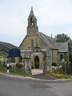
Higher Porthpean is a village south of Duporth and contiguous with Lower Porthpean in Cornwall, England. It has a small church, dedicated to St Levan that is a Grade II building, and that seats 48 people. The church is a Chapel of ease to St Austell Parish Church
Muchlarnick is a hamlet in Cornwall, England. It is about two miles east of Lanreath in the civil parish of Pelynt.

Pencuke is a hamlet near Higher Crackington in northeast Cornwall, England, UK.
Pengold is a hamlet near St Gennys in Cornwall, England, UK. Pengold is southwest of Higher Crackington.
Penpillick is a hamlet in Cornwall, England, UK. It is about two miles north of St Blazey on the A390 road.
Rosecare is a hamlet in the parish of St Gennys, Cornwall, England. Rosecare is east of Higher Crackington.

The River Kensey is a river in east Cornwall, England, UK which is a tributary of the River Tamar.

The River Lerryn is a river in east Cornwall, England, UK, a tributary of the River Fowey. The Lerryn is the largest of the tributaries which enter the estuary of the Fowey. The river is tidal up to the village of Lerryn. The landscape of the Lerryn catchment is rural and includes heathland, moorland and rough pasture in the upper reaches and broadleaf, coniferous and mixed plantation woodland in the lower. This catchment includes four SSSIs, including Redlake Meadows & Hoggs Moor. The Lerryn rises at Fairy Cross on the southern slopes of Bodmin Moor and flows south-southwest until it enters the Fowey estuary.
References
- ↑ Ordnance Survey: Landranger map sheet 201 Plymouth & Launceston' (Map). Ordnance Survey. ISBN 978-0-319-23287-3.
- ↑ Higher Tremarcoombe; Explore Britain
| Unitary authorities | |
|---|---|
| Major settlements |
|
| Rivers | |
| Topics | |
Coordinates: 50°29′55″N4°28′05″W / 50.4984783°N 4.4679727°W
| This Cornwall location article is a stub. You can help Wikipedia by expanding it. |