Related Research Articles

Coleford is a small hamlet in Mid-Devon, England. It includes a pub, and also has a park.

The River Hayle is a small river in West Cornwall, England, United Kingdom which issues into St Ives Bay at Hayle on Cornwall's Atlantic coast.

Blowinghouse is the name of two settlements in Cornwall, England, United Kingdom.

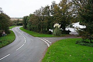
Carland Cross is a location in Cornwall, England, United Kingdom, about six miles north of Truro at OS grid reference OS grid ref SW846539. At Carland Cross there are a hamlet, a road junction and a large wind farm. The road junction is in the civil parish of St Erme, very close to the boundary with St Newlyn East.

The River Allen in north Cornwall is one of two rivers of the same name in Cornwall which share this name. In this case the name is the result of a mistake made in 1888 by Ordnance Survey, replacing the name Layne with Allen which is the old name for the lower reaches of the Camel. The other River Allen runs through Truro.

The De Lank River is a small river in north Cornwall, England. It is a tributary of the River Camel and is approximately nine miles (14.5 km) long from its source on Bodmin Moor to its confluence with the Camel two miles (3 km) south of St Breward.
Broadlane is a hamlet in the parish of Breage, Cornwall, England.
Cambrose is a hamlet east of Portreath in west Cornwall, England, UK.

Hick's Mill is a hamlet in Cornwall, England. It is about a mile southeast of Trewen on the River Inny. It is in the civil parish of Gwennap

Nanceddan is a farm north of Ludgvan in west Cornwall, England.
Newtown is a hamlet in the parish of Germoe, Cornwall, England.
Newtown-in-St Martin is a hamlet in the parish of St Martin-in-Meneage, Cornwall, England. Newtown is south-southeast of St Martin's Green.
Paul's Green is a hamlet between Leedstown and Townshend in west Cornwall, England, UK.
Penelewey is a hamlet southeast of Playing Place in Cornwall, England, UK. Penelewey is on the B3289 road.
Pengegon is a residential area east of Camborne, Cornwall, England, which has a fish and chip shop, a newsagent, a children's play park and a basketball/football court.
Penmayne is a hamlet next to Splatt in the civil parish of St Minver Lowlands in north Cornwall, England, UK.
Penpillick is a hamlet in Cornwall, England, UK. It is about two miles north of St Blazey on the A390 road.

Rose-an-Grouse is a hamlet in the civil parish of St Erth in west Cornwall, England. It is on the A30 road, east of Canon's Town, and St Erth railway station is on the southern side of the hamlet.

The River Kensey is a river in east Cornwall, England, UK which is a tributary of the River Tamar.
Tywardreath Highway is a hamlet in Cornwall, England, located near the village of St Blazey.
References
- ↑ Ordnance Survey: Landranger map sheet 203 Land's End & Isles of Scilly (Map). Ordnance Survey. 2009. ISBN 978-0-319-23289-7.
- ↑ Highway; Explore Britain
| Unitary authorities | |
|---|---|
| Major settlements |
|
| Rivers | |
| Topics | |
Coordinates: 50°14′48″N5°12′19″W / 50.2466°N 5.20539°W
| This Cornwall location article is a stub. You can help Wikipedia by expanding it. |