
The Boston Post Road was a system of mail-delivery routes between New York City and Boston, Massachusetts, that evolved into one of the first major highways in the United States.

Bristol County is a county in the Commonwealth of Massachusetts. As of the 2020 census, the population was 579,200. The shire town is Taunton. Some governmental functions are performed by the Commonwealth of Massachusetts, others by the county, and others by local towns and cities.
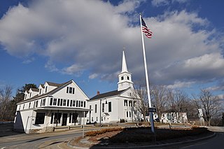
Dartmouth is a coastal town in Bristol County, Massachusetts, United States. Old Dartmouth was the first area of Southeastern Massachusetts to be settled by Europeans, primarily English. Dartmouth is part of New England's farm coast, which consists of a chain of historic coastal villages, vineyards, and farms. June 8, 2014, marked the 350th year of Dartmouth's incorporation as a town. It is also part of the Massachusetts South Coast. The local weekly newspapers are The Dartmouth/Westport Chronicle and Dartmouth Week. The Portuguese municipality of Lagoa is twinned with the town; along with several other Massachusetts and Rhode Island towns and cities around Bristol County.
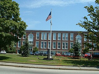
Fall River is a city in Bristol County, Massachusetts, United States. Fall River's population was 94,000 at the 2020 United States census, making it the tenth-largest city in the state. It abuts the Rhode Island state line with Tiverton, RI to its south.

Hopkinton is a town in Middlesex County, Massachusetts, United States, 25 miles (40 km) west of Boston. The town is best known as the starting point of the Boston Marathon, held annually on Patriots' Day each April, and as the headquarters for the Dell EMC corporation.

U.S. Route 240 is a defunct designation for a short, but once very important, segment of highway between Frederick, Maryland, and Washington, D.C. It is now commonly known as Wisconsin Avenue, Maryland Route 355, and Interstate 270 (I-270).

Interstate 195 (I-195) is an auxiliary Interstate Highway running a combined 44.55 miles (71.70 km) in the US states of Rhode Island and Massachusetts. It travels from a junction with I-95 in Providence, Rhode Island, east to a junction with I-495 and Massachusetts Route 25 in Wareham, Massachusetts. It runs east–west and passes through the cities of Fall River, Massachusetts, and New Bedford, Massachusetts. The portion of I-195 in East Providence is also known as the East Providence Expressway.

Massachusetts Route 6A is the state road for two sections formerly known as U.S. Route 6 (US 6) on Cape Cod. Most of Route 6A is also known as the Old King's Highway. Combining the 2 major sections, the highway is approximately 62 miles (100 km) long.

Interstate 95 (I-95) is the main north–south Interstate Highway on the East Coast of the United States, running generally southwest–northeast through the US state of Rhode Island. It runs from the border with Connecticut near Westerly, through Warwick and Providence, and to the Massachusetts state line in Pawtucket. It has two auxiliary routes, both of which enter Massachusetts—I-195, a spur from Providence east to Cape Cod, and I-295, a western bypass of the Providence metropolitan area.
Columbus, the state capital and Ohio's largest city, has numerous neighborhoods within its city limits. Neighborhood names and boundaries are not officially defined. They may vary or change from time to time due to demographic and economic variables.

U.S. Route 6 (US 6) in Massachusetts is a 117.952-mile-long (189.825 km) portion of the cross-country route connecting Providence, Rhode Island, to Fall River, New Bedford, and Cape Cod. In the Fall River and New Bedford areas, US 6 parallels Interstate 195 (I-195). On Cape Cod, US 6 is a highway interconnecting the towns of the area. The freeway section in this area is also known as the Mid-Cape Highway. The highway is also alternatively signed as the "Grand Army of the Republic Highway".
Preston City is a village and the original town center of the town of Preston, Connecticut. The core of the village around the junction of Old Northwest Road and Route 164 is designated as the Preston City Historic District, a historic district that is listed on the National Register of Historic Places. The district is located along Old Shetucket and Amos Roads, which, prior to the 1930s, were major thoroughfares.
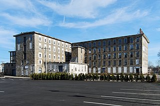
Wampanoag Mills is a historic textile mill complex located at 420 Quequechan Street in Fall River, Massachusetts. Built beginning in 1871, it is a large and well-preserved example of granite textile mill construction. The site was added to the National Register of Historic Places in 1983.

The Russells Mills Village Historic District is a historic district on Russells Mills, Rock O' Dundee, Slades Corner, Horseneck and Fisher Roads in Dartmouth, Massachusetts. It encompasses an area that was an early industrial center, flourishing from the 18th century into the early 19th century. The district was added to the National Register of Historic Places in 1985.

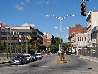
Downtown Fall River Historic District is a historic district on North and South Main, Bedford, Granite, Bank, Franklin, and Elm Streets in Fall River, Massachusetts.

Luther's Corner is a historic district encompassing the original economic center of Swansea, Massachusetts. The district is centered on the junction of Old Warren and Pearse Roads, the former being a major stage route between Fall River and Providence, Rhode Island, and was for many years associated with the locally prominent Luther Family. Luther's Corner was added to the National Register of Historic Places in 1990.

Cedar Swamp Archeological District is a prehistoric and historic archaeologically sensitive area in eastern Westborough, Massachusetts, and extending into the northwest corner of Hopkinton. Cedar Swamp is an area of more than 2,600 acres (1,100 ha) of wetlands that include the headwaters area of the Sudbury River. Archeological surveys of the environmentally sensitive and critical area have identified many Native American sites of interest. It is believed that Native Americans prized wood from the cedar trees that grew in the area. The archeological district, which encompasses much of the Cedar Swamp area, was added to the National Register of Historic Places in 1988.

The Ashfield Plain Historic District is a historic district roughly, along Main and South Streets and adjacent parts of Buckland and Norton Hill Roads in Ashfield, Massachusetts. It encompasses the village center of the town, which has acted as a civic and commercial center since the late 18th century. Its architectural heritage dates back to that time, but is now dominated by buildings from the late 19th and early 20th centuries. The district was listed on the National Register of Historic Places in 1991.

The Head of the River Historic District is a historic district encompassing a village area at the head of navigation of the Acushnet River, which separates Acushnet and New Bedford, Massachusetts. The village is centered at the junction of Tarkin Hill Road, River Road, and Mill Road in New Bedford, and Main Street in Acushnet. The area went through two significant periods of development: the first was in the late 18th and early 19th century, and the second was in the early 20th century. The district was listed on the National Register of Historic Places in 2009.
The Dublin Village Historic District encompasses the historic village center of Dublin, New Hampshire. Dublin's center developed in the 19th century after its original village center was abandoned due to harsher winter conditions nearer Dublin Pond. The district extends along Main Street from its junction with Lake Street in the west to the junction with Old County Road in the east, and includes sections of Old Common Road, Harrisville Road, and Church Street. The district was listed on the National Register of Historic Places in 1983.


