
The Ashburnham Center Historic District is a historic district encompassing the core of the village center of Ashburnham, Massachusetts in the United States. It is a well-preserved industrial village that experienced its most significant period of growth in the mid-19th century. The district was added to the National Register of Historic Places in 1999.

The Newtonville Historic District is a historic district in the village of Newtonville, in Newton, Massachusetts. The district encompasses the southern portion of the village's business district, as well as surrounding residential areas. It was listed on the National Register of Historic Places in 1986, and enlarged in 1990.

The Edgartown Village Historic District is a historic district encompassing the traditional center of Edgartown, Massachusetts, on the island of Martha's Vineyard. The district is roughly bounded by Water St. and Pease's Point Way, and encompasses some 500 acres (200 ha). The buildings within the district primarily represent the period of Edgartown's growth in the 19th century, featuring the elaborate houses of wealthy ship captains, as well as significant public buildings such as the Dukes County Courthouse and Jail, the Federated Church, and the Whaling Church. The district was listed on the National Register of Historic Places in 1983.

The Old Centre Historic District is a historic district encompassing the historic town center of Winchendon, Massachusetts. It includes the town's first cemetery, the First Congregational Church, and the oldest surviving house in town, and only one building constructed after 1850. The district was added to the National Register of Historic Places in 1987.

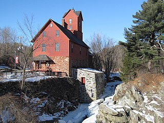
Old Curtisville Historic District encompasses the village center of Interlaken in Stockbridge, Massachusetts. It is historically significant as the site of the first wood-based newsprint paper mill in the United States, and has a well-preserved collection of late 18th and early 19th-century architecture. It was listed on the National Register of Historic Places in 1976.

The Montague Center Historic District encompasses the well-preserved 19th century village center of Montague, Massachusetts. Montague Center, one of the town's five villages, is the civic heart of the town, and was also an active industrial area in the 19th century. The district was listed on the National Register of Historic Places in 2001.

The North Hadley Historic District encompasses the historic rural village of North Hadley, located between Mount Warner and the Connecticut River in Hadley, Massachusetts. It includes properties on River Drive between Stockwell Road and Stockbridge Street, and includes properties on French, Meadow and Mt. Warner Streets. It is a well-preserved example of a rural farming and mill community, with architecture dating from the late 18th to early 20th centuries. The district was listed on the National Register of Historic Places in 1993.

The Boston Post Road Historic District encompasses a portion of the historic roadway known as the Boston Post Road, which ran Boston, Massachusetts to Albany, New York. The surviving alignment in Weston, Massachusetts extends along the entire length of United States Route 20, except for a bypassed section that passes through the town's village center. The 3.5 miles (5.6 km) of roadway retains much of the generally rural appearance it had during the late colonial period, and the town center retains significant elements of historic character as well. The district was added to the National Register of Historic Places in 1983.

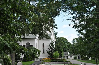
The Common Historic District is a historic district encompassing the civic and institutional heart of Reading, Massachusetts. The district is centered on the town common, at the intersection of Main and Salem Streets. The common has been communally owned since at least 1737, with the original burying ground to the north. In 1769 the area's first meeting house was built, giving the area a sense of identity separate from portions of Reading that would later be set off as Wakefield and North Reading. Since then the area has become a focal point for religious and civic institutions in the town.
The Newton Lower Falls Historic District encompasses the historic colonial village center of Newton Lower Falls, on the west side of Newton, Massachusetts. This area lies north of Washington Street, along Concord and Grove Streets, between Washington and Hagar Streets. The district was listed on the National Register of Historic Places in 1986.

The Brookline Town Green Historic District encompasses the historic colonial heart of the town of Brookline, Massachusetts. Centered on a stretch of Walnut Street between Warren and Chestnut Streets, this area is where the town's first colonial meeting house and cemetery were laid out, and was its center of civic life until the early 19th century. The district was listed on the National Register of Historic Places in 1980.

The Amherst Village Historic District encompasses the historic village center of Amherst, New Hampshire. Centered on the town's common, which was established about 1755, Amherst Village is one of the best examples of a late-18th to early-19th century New England village center. It is roughly bounded on the north by Foundry Street and on the south by Amherst Street, although it extends along some roads beyond both. The western boundary is roughly Davis Lane, the eastern is Mack Hill Road, Old Manchester Road, and Court House Road. The district includes the Congregational Church, built c. 1771-74, and is predominantly residential, with a large number of Georgian, Federal, and Greek Revival houses. Other notable non-residential buildings include the Farmer's Bank, a Federal-style brick building built in 1806, and the Amherst Brick School, a brick Greek Revival structure that has served as the School Administrative Unit 39 offices since 1997.

The York Historic District encompasses the historic village center of York, Maine, one of the oldest communities in the state. The expansive 1,700-acre (690 ha) district includes the oldest church in Maine, built by its oldest congregation in 1747, and the Old York Gaol, a National Historic Landmark that is one of the oldest public buildings in the United States. The district was listed on the National Register of Historic Places in 1973.

The Wakefield Village Historic District encompasses the historic village center of Wakefield, New Hampshire. It is centered at the junction of New Hampshire Route 153 and Mountain Laurel Road, which was historically the major north–south route in Carroll County. The district consists mainly of residential properties dating from the 18th to early 20th centuries, and also includes the 1836 town hall, public library¸ Grange Hall, and a one-room schoolhouse that now houses the local historical society. The district was listed on the National Register of Historic Places in 1984.

The Town Center Historic District encompasses the historic village center of South Hampton, New Hampshire. Centered around the Barnard Green, the town common, on New Hampshire Route 107A, it includes architectural reminders of the town's growth and change over time. The district was listed on the National Register of Historic Places in 1983.

The Dorset Village Historic District encompasses a significant portion of the village center of Dorset, Vermont. Centered at the junction of Church Street, Kent Hill Road, and Vermont Route 30, the village was developed between the late 18th and early 20th centuries, and has a number of well-preserved unusual features, including sidewalks of marble from local quarries. The district was listed on the National Register of Historic Places in 1985, and was enlarged to the west in 1997.
The Jericho Village Historic District encompasses the historic industrial and commercial center of the village of Jericho, Vermont. Stretched along Vermont Route 15 south of Browns River, which powered the village's industries for many years, the village center includes a well-preserved array of 19th and early 20th-century buildings. The district was listed on the National Register of Historic Places in 1992.

The Rockwood Road Historic District encompasses a portion of the town center of Norfolk, Massachusetts that has retained significant 19th-century characteristics. It extends along Rockwood Road from the MBTA Commuter Rail line to Boardman Street. This area consists mainly of residential or former residential buildings, as well as the 1863 Norfolk Grange Hall, a former church, and is reflective of the center's growth as a railroad village. The district was added to the National Register of Historic Places in 2017.
The Oakham Center Historic District encompasses a portion of the historic town center of Oakham, Massachusetts. Roughly bounded by Coldbrook Rd., Maple St., Barre Rd., and Deacon Allen Drive, the area was formed as a civic center about 1770, with town incorporation following in 1775. It includes a well-preserved variety of early 19th-century residential architecture, as well as the town's Greek Revival Congregational church, and its 1908 library. The district was listed on the National Register of Historic Places in 2020.

The Lenox Village Historic District is a historic district encompassing the historic village center of Lenox, Massachusetts. Settled in the 1760s, Lenox was the second county seat of Berkshire County, a role it served until 1868, and its early economic success revolved around this role and local mining industries. The village center is reflective of this early role, as well as its later role as a hub for wealthy vacationers. The district was listed on the National Register of Historic Places in 2022.


