
Roxbury is a neighborhood within the City of Boston, Massachusetts, United States.

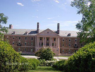
The Metropolitan State Hospital was an American public hospital for the mentally ill, on grounds that extended across parts of Waltham, Lexington, and Belmont, Massachusetts. Founded in 1927, it was at one time the largest and most modern facility of its type in Massachusetts. It was closed in January 1992 as a result of the state's cost-cutting policy of closing its mental hospitals and moving patients into private and community-based settings. The main complex of buildings has subsequently been redeveloped into apartments. The hospital campus was listed on the National Register of Historic Places 1994. The property also housed the Gaebler Children's Center for mentally ill youth.

Dorchester is a neighborhood comprising more than 6 square miles (16 km2) in the City of Boston, Massachusetts, United States. Originally, Dorchester was a separate town, founded by Puritans who emigrated in 1630 from Dorchester, Dorset, England, to the Massachusetts Bay Colony. This dissolved municipality, Boston's largest neighborhood by far, is often divided by city planners in order to create two planning areas roughly equivalent in size and population to other Boston neighborhoods.

Beacon Hill is a historic neighborhood in Boston, Massachusetts, United States, and the hill upon which the Massachusetts State House resides. The term "Beacon Hill" is used locally as a metonym to refer to the state government or the legislature itself, much like Washington, D.C.'s Capitol Hill does at the federal level.
Willowbrook is a neighborhood in Staten Island, one of the five boroughs of New York City. It is located in the region of the island usually referred to as Mid-Island, immediately to the south of Port Richmond, to the west of Meiers Corners and Westerleigh, to the north of New Springville, and to the east of Bulls Head.

Mattapan is a neighborhood in Boston, Massachusetts, United States. Historically and for legal processes a section of Dorchester, Mattapan became a part of Boston when Dorchester was annexed in 1870. Mattapan is the original Native American name for the Dorchester area, possibly meaning "a place to sit." At the 2010 census, it had a population of 36,480, with the majority of its population immigrants.

Mission Hill is a 3⁄4 square mile, primarily residential neighborhood of Boston, bordered by Roxbury, Jamaica Plain and Fenway-Kenmore and the town of Brookline. The neighborhood has two main streets, namely Tremont Street and Huntington Avenue. It is served by several stations on the MBTA's Green Line E branch, as well as Roxbury Crossing station on the Orange Line.

Schuyler Mansion is a historic house at 32 Catherine Street in Albany, New York. The brick mansion is now a museum and an official National Historic Landmark. It was constructed from 1761 to 1765 for Philip Schuyler, later a general in the Continental Army and early U.S. Senator, who resided there from 1763 until his death in 1804. It was declared a National Historic Landmark on December 24, 1967. It is also a contributing property to the South End–Groesbeckville Historic District, listed on the National Register of Historic Places in 1984.
The Daniel Webster Family Home, also known as The Elms, is a historic house off South Main Street in West Franklin, New Hampshire. The house has been designated a National Historic Landmark for its importance as the summer home of Daniel Webster (1782–1852), who owned it from 1829 until his death.
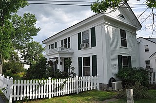
The Pleasant View Home is an historic senior citizen residential facility located at 227 Pleasant Street in Concord, New Hampshire, in the United States. On September 19, 1984, it was added to the National Register of Historic Places.

Mountain View is a Roanoke, Virginia neighborhood located in central Roanoke north of the Roanoke River. It borders the neighborhoods of Norwich on the west, West End on the east, Hurt Park on the north and Raleigh Court and Wasena on the south.
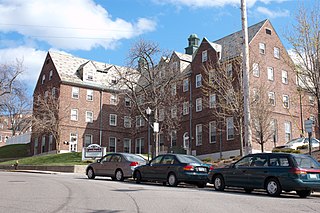
The Edward H. Haskell Home for Nurses, also known as the New England Baptist Hospital Training School For Nurses, is a historic academic complex in the Mission Hill neighborhood of Boston, Massachusetts. Its original building, a 1-1/2 to 2+1⁄2-story brick-faced wood-frame building, was designed by Edward Sears Read in the Jacobethan style and built in 1922. This building originally housed a dormitory and classrooms. In 1931 a large wing gave the building an L shape, and another series of additions in 1940 gave the complex its present appearance, surrounding a courtyard atop Parker Hill. The complex was converted into an assisted-living facility in 2002.

Abbotsford, now the Museum of the National Center of Afro-American Artists, is a historic house at 300 Walnut Avenue in Boston, Massachusetts, USA. The museum is dedicated to black visual arts heritage worldwide, and presents historical and contemporary exhibitions in many media, including painting, sculpture, graphics, photography and decorative arts. The museum is operated by the National Center of Afro-American Artists.

The Working Boys Home is a historic orphanage building at 333 Nahanton Street in Newton, Massachusetts.

The Hebrew Orphan Asylum is a historic institutional orphanage and former hospital building located in the Mosher neighborhood of Baltimore, Maryland, United States. It has also been known as West Baltimore General Hospital, Lutheran Hospital of Maryland and is currently being redeveloped by Coppin Heights Community Development Corporation to be a Center for Healthcare & Healthy Living.
Built in 1875, the Hebrew Orphan Asylum in Baltimore, Maryland replaced the old Calverton Mansion when a fire destroyed the mansion in 1874. The Hebrew Orphan Asylum, which started in 1872 in the Calverton Mansion depended on donations from people within the Baltimore Jewish community, including the wealthy German Jewish community that had settled within the city. The history of the asylum follows the history of the Jewish community in Baltimore, which increased rapidly with immigration from Europe in the 19th and 20th centuries. The building transitioned to serve as the West Baltimore General Hospital from 1923 through 1950 and finally the Lutheran Hospital of Maryland from 1950 to 1989. While associated structures associated with the Hebrew Orphan Asylum, the West Baltimore General Hospital, and the Lutheran Hospital of Maryland were demolished in 2009, the original four-story brick Romanesque structure still stands.
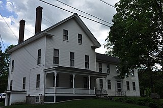
The Dr. Solomon M. Whipple House, also known as the Clough or Woodward House, is a historic house on Main Street in the center of New London, New Hampshire. Built in 1850 for a long-serving doctor, it is the only Greek Revival house in the town. It was listed on the National Register of Historic Places in 1985. It is now the front portion of an assisted living facility.

Mount Vernon Triangle is a neighborhood and community improvement district in the northwest quadrant of Washington, D.C. The neighborhood is located adjacent to Mount Vernon Square. Originally a working-class neighborhood established in the 19th century, present-day Mount Vernon Triangle experienced a decline in the mid-20th century as it transitioned from residential to commercial and industrial use.

Fort Hill is a 0.4 square mile neighborhood and historic district of Roxbury, in Boston, Massachusetts. The approximate boundaries of Fort Hill are Malcolm X Boulevard on the north, Washington Street on the southeast, and Columbus Avenue on the southwest.

Louis Weissbein (1831–1913) was a German-born American architect practicing in Boston, Massachusetts.

The National Home for Destitute Colored Women and Children, later known as the Merriweather Home for Children, was a relief association in the Pleasant Plains neighborhood of Washington, D.C.


