
Hougham Battery is a World War II coastal defence battery built in 1941 between Dover and Folkestone in southeast England. It is on the cliff-edge between Abbot's Cliff and Shakespeare Cliff.
Barkston is an English village and civil parish in the South Kesteven district of Lincolnshire. The parish population was 497 at the 2001 census and 493 at the 2011 census. The village lies about 4 miles (6 km) north of the market town of Grantham, on the A607, just south of the junction with the A153 to Ancaster.

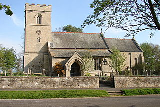
Capel-le-Ferne is a village on the White Cliffs of Dover, near Folkestone in Kent, England. Its name derives from a medieval French term meaning "chapel in the ferns". In 2011 the village had a population of 1,884. It is perched on top of the White Cliffs of Dover.

Barham is a village and civil parish in the City of Canterbury district of Kent, England. Barham village is approximately 6 miles (10 km) south-east from Canterbury and 8 miles (13 km) north from Folkestone.

Barton-on-the-Heath is a village and civil parish in the Stratford-on-Avon district of Warwickshire, England. According to the 2001 census the parish had a population of 85. From the Census 2011 population details are included in the neighbouring civil parish of Little Compton. The village is in the extreme south of Warwickshire, close to the borders with Gloucestershire and Oxfordshire. There is a church, dedicated to St Lawrence.

Rogate is a village and civil parish in the Chichester district of West Sussex, England, in the Western Rother valley. The village is on the A272 road 5.6 miles (9.0 km) west of Midhurst and 5 miles (8.0 km) east of Petersfield, Hampshire. The civil parish includes the villages of Rogate and Rake and the hamlets of Haben, Fyning, Hill Brow, Langley, Durford, Wenham, Durleighmarsh and Terwick Common.
Linchmere, also spelled Lynchmere, is a village and a civil parish, the northernmost parish in the Chichester district of West Sussex, England. It is between Haslemere and Liphook, south of the B2131 road. As well as Linchmere village, the parish contains the settlements of Hammer and Camelsdale.

River is a village and civil parish in Kent, England, situated very close to the historic town of Dover, the town centre of which is only 2 miles to the south, and the neighbouring village of Temple Ewell. The 2011 census recorded a population of 3,876 in the village. River is 1 mile south west of the A2 and 2 miles north of the A20, and a railway station at Kearsney provides direct access to London.

Minety (/'maɪn.tiː/) is a village in north Wiltshire, England, between Malmesbury – 6 miles (9.7 km) to the west – and Swindon. It takes its name from the water mint plant found growing in ditches around the village, and has previously been known as Myntey. It has a primary school and a successful rugby club.
Stourmouth is a civil parish in the Dover non-metropolitan district of Kent, England. The parish contains the settlements of East and West Stourmouth, and the hamlet of Plucks Gutter.

Snelston is a village and civil parish three miles south-west of Ashbourne in Derbyshire, England. It includes Anacrehill. The population of the civil parish as of the 2011 census was 202. A tributary of the River Dove flows through its centre.
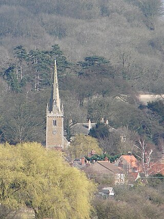
Hougham is a village and civil parish in the South Kesteven district of Lincolnshire, England, 6 miles (10 km) north from Grantham. The village of Marston, Lincolnshire is its closest neighbour, just under 1 mile (1.6 km) to the south.

Sutton is a village and civil parish near Dover in Kent, England. In 1935 this village became a parish when the small settlements of Studdal, Sutton, Ashley, Little Mongeham and Maydensole joined to become the Parish of Sutton-by-Dover. Prior to this Sutton has had a vast history of agricultural practices, which has helped sustain the village into the parish it is today. The quoted population includes the villages of East and West Studdal plus Swingate and the hamlet of Little Mongeham.

Walgherton is a village and civil parish in the unitary authority of Cheshire East and the ceremonial county of Cheshire, England. The village lies at SJ697489 by the junction of the A51 and B5071 roads, 3½ miles to the south east of Nantwich and 4½ miles to the south of Crewe. The civil parish also includes the small settlement of Hussey's Nook. The total population is just under 130 people. Sand has been extracted at Hough Mill Quarry. The remainder of the parish is predominantly agricultural. Nearby villages include Hatherton, Stapeley and Wybunbury.
Warmingham is a village and civil parish in the unitary authority of Cheshire East and ceremonial county of Cheshire, England, on the River Wheelock, 3.25 miles (5.23 km) north of Crewe, 3.25 miles (5.23 km) south of Middlewich and 3.25 miles (5.23 km) miles west of Sandbach. The parish also includes the small settlement of Lane Ends, with a total population of just under 250. Nearby villages include Minshull Vernon, Moston and Wimboldsley.
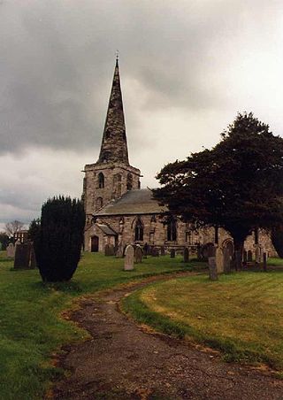
Marston on Dove is a village and civil parish in South Derbyshire, nine miles (14 km) south west of Derby and two miles (3.2 km) east of Tutbury. The Church of St Mary at Marston has the oldest bell in Derbyshire, which was cast in Leicester in 1366 and inscribed with the words "Hail Mary" by John de Stafford.
Carlton Scroop is a small village and civil parish in the South Kesteven district of Lincolnshire, England. The population of the civil parish at the 2011 census was 304. It is situated 6 miles (10 km) north-east from the market town of Grantham and 4 miles (6 km) east from the village of Hougham. The A607 road to Lincoln passes through the centre of the village.

Pillerton Hersey is a village and civil parish about 5.5 miles (9 km) north of Shipston-on-Stour in Warwickshire, England. The village is on a stream that flows northwest to join the River Dene. The 2011 Census recorded the parish's population as 170.

Cretingham is a village and a civil parish in the East Suffolk district, in the English county of Suffolk. It is on the River Deben, 2 miles south off the A1120 road. It is four miles west from Framlingham and eight miles northwest from Woodbridge.


