
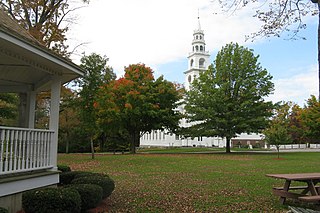
The Rockingham Meeting House, also known as Old North Meeting House and First Church in Rockingham, is a historic civic and religious building on Meeting House Road in Rockingham, Vermont, United States. The Meeting House was built between 1787 and 1801 and was originally used for both Congregational church meetings as well as civic and governmental meetings. Church services ceased in 1839 but town meetings continued to be held in it until 1869. It was restored in 1906 and has been preserved.

The East Hoosac Quaker Meetinghouse is a historic Quaker meeting house in Adams, Berkshire County, Massachusetts. The meetinghouse's construction dates to the early 1780s. It now occupies a prominent position within the Maple Street Cemetery, the first burial ground in Adams. Unmarked graves of Adams' early Quaker settlers lie near the meetinghouse, an area now marked by a plaque. The meetinghouse was listed on the National Register of Historic Places in 1976.

The Lunenburg Historic District is a historic district encompassing the historic center of Lunenburg, Massachusetts. The district is centered on a stretch of Main Street which connects two triangular intersections. It includes many of the town's oldest buildings, including the c. 1724 Cushing House, and the c. 1730 Stillman Stone House. Three of the town's most significant institutional buildings were built before 1850: the town hall, the Congregational church, and the Methodist church. The district was added to the National Register of Historic Places in 1988.

The Harvard Center Historic District is a historic district encompassing the traditional village center of Harvard, Massachusetts, USA. The district is centered on the town common, a triangular grassy space bounded by Elm Street, Still River Road, and Ayer Road. The common is ringed by residences, civic and religious buildings, and a small commercial area. The common was laid out when the town was founded in 1732, and has grown, mainly in periods of growth at the late 18th and late 19th/early 20th centuries. Most of the village's buildings post-date 1831. The district was added to the National Register of Historic Places in 1997.
The Templeton Common Historic District encompasses the historic town center of Templeton, Massachusetts. Laid out in the 1750s, the area has been the focus of the town's civic and economic affairs since, and includes its finest assortment of 18th and early 19th-century architecture. The district was added to the National Register of Historic Places in 1983. The district was in 2010 named as one of the 1,000 places to visit in Massachusetts by the Great Places in Massachusetts Commission.

Becket Center Historic District is a historic district encompassing the historic early center of Becket, Massachusetts. Centered at the junction of Massachusetts Route 8 and YMCA Road, this area was the town's civic heart and a center of industry until it was eclipsed in importance by North Becket, which was served by the railroad. Most of the architecture in the district is in the Federal and Greek Revival styles popular in the late 18th to mid 19th centuries. The district was added to the National Register of Historic Places in 1982.

The Sheffield Plain Historic District encompasses the original 18th-century village center of Sheffield, Massachusetts, United States. The linear district extends southward about 0.5 miles (0.80 km) from the junction of United States Route 7 and Cook Road, where the original town common is located. The district was primarily developed in the mid-18th and early 19th centuries. It was listed on the National Register of Historic Places in 1988.

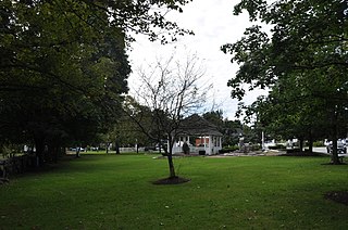
The Upper Historic District is a historic district encompassing the historic center of Washington, Massachusetts. Centered on the junction of Washington Mountain Road and Branch Road, the town center flourished from the town's establishment in the 1750s until the center of the town's business moved closer to the newly lain railroad in the 1830s. The district includes the old town hall, cemetery, common, and pound, as well as a number of residences. A meeting house (church) and schoolhouse once stood in the area, but the 1792 church was destroyed by lightning in 1859, and the schoolhouse is no longer extant. The district was added to the National Register of Historic Places in 1987.

The Ludlow Center Historic District encompasses the historic village center of Ludlow, Massachusetts. Centered on the junction of Center, Church and Booth Streets, it is the site selected as the town center when Ludlow was established in 1774. Its notable structures include the Congregational Church, the old town hall, and a number of farmhouses that date to the first half of the 19th century. The area has remained a center of civic life in the town, even though its economic center moved later in the 19th century to Ludlow Village. The district was listed on the National Register of Historic Places in 1988.

The Hamilton Historic District encompasses the early historic center of Hamilton, Massachusetts. It includes properties at 540-700 and 563-641 Bay Road, extending along the road from Orchard Road in the south to Cutler Road in the north. Numerous Greek Revival buildings are located within the district including the First Congregational Church of Hamilton, built in 1843. The district was added to the National Register of Historic Places in 1973.

The Common Historic District is a historic district encompassing the civic and institutional heart of Reading, Massachusetts. The district is centered on the town common, at the intersection of Main and Salem Streets. The common has been communally owned since at least 1737, with the original burying ground to the north. In 1769 the area's first meeting house was built, giving the area a sense of identity separate from portions of Reading that would later be set off as Wakefield and North Reading. Since then the area has become a focal point for religious and civic institutions in the town.

The Common District encompasses the main civic center of Wakefield, Massachusetts. It is centered on the historic town common, just south of Lake Quannapowitt, which was laid in 1644, when it became the heart of Old Reading. The area was separated from Reading as South Reading in 1818, and renamed Wakefield in 1868. The 25 acre district includes the buildings that line the common on Common Street and Main Street, which include the town hall, public library, YMCA, post office, and several churches. It was listed on the National Register of Historic Places in 1990.
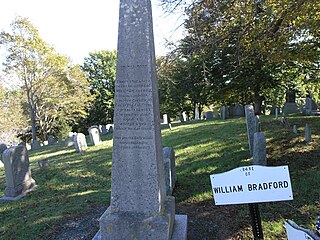
Burial Hill is a historic cemetery or burying ground on School Street in Plymouth, Massachusetts. Established in the 17th century, it is the burial site of several Pilgrims, the founding settlers of Plymouth Colony. It was listed on the National Register of Historic Places in 2013.

The Brookline Town Green Historic District encompasses the historic colonial heart of the town of Brookline, Massachusetts. Centered on a stretch of Walnut Street between Warren and Chestnut Streets, this area is where the town's first colonial meeting house and cemetery were laid out, and was its center of civic life until the early 19th century. The district was listed on the National Register of Historic Places in 1980.

The Second Rindge Meetinghouse, Horsesheds and Cemetery is a historic meeting house and cemetery on Old US 202 and Rindge Common in Rindge, New Hampshire. Built in 1796, it is relatively distinctive in New England as one of few such meeting houses where both civic and religious functions are still accommodated, housing both the town offices and a church congregation. The town's first cemetery, established in 1764, lies to the north of the meetinghouse. It is the resting place of many of Rindge's early settlers, and of its American Revolutionary War veterans. Behind the meetinghouse stand a row of horse sheds, the only one of the two rows of them which originally served the meetinghouse. The property was listed on the National Register of Historic Places in 1979.
The Springfield Town Hall and Howard Memorial Methodist Church, also known as the Springfield Union Meeting House, is a historic civic and religious building on Four Corners Road in Springfield, New Hampshire, USA. Built about 1797 and restyled in 1851, it is a rare surviving example in the state of a meeting house whose functions include both civic and religious uses. It is also a good example of Greek Revival and Gothic architecture, and was listed on the National Register of Historic Places in 1986.
The New Ipswich Center Village Historic District encompasses the historic center of the rural town of New Ipswich, New Hampshire. The center village is the town's most densely populated area, with a history dating to the town's founding in 1735. The district extends along Turnpike Road between King and Porter Roads, and southward in a roughly triangular shape, the southern point of which is at the junction of Main Street and Willard Road. The village includes a large number of residences, which were mainly agricultural at first, but also include a number of properties built as summer resort houses in the late 19th and early 20th centuries. It also includes most of the town's historic civic buildings, including its historic town hall, and the Barrett House, now a museum property owned by Historic New England. The district was listed on the National Register of Historic Places in 1991.
The Salem Common Historic District encompasses the early colonial center of Salem, New Hampshire. The district dates to the earliest period of settlement of Salem, and includes the historic common, old town hall, fire station, and library. The town hall was built in 1738 and extensively altered in 1838 and 1899; it served as a place for town meetings until 1958. The district was listed on the National Register of Historic Places in 2011.
The Sedgwick Historic District encompasses the historic and traditional rural center of the small town of Sedgwick, Maine. Located at the junction of Maine State Route 172 and Old County Road, the district includes the town's 1793 meeting house, which still serves as town hall, the c. 1795 Daniel Merrill House, built for the town's first minister, the 1821 town pound, and its first cemetery. The district was listed on the National Register of Historic Places in 1995.

The Southborough Center Historic District encompasses a historically significant portion of the town center of Southborough, Massachusetts. It extends from the Fay School grounds in the west, along Main Street to the railroad crossing east of Lanisquama Road. The area has been the town center since its founding in 1727, and now houses a diversity of 19th and early 20th-century architecture. The district was added to the National Register of Historic Places in 1990.


