
Nazareth is a borough in Northampton County, Pennsylvania, United States. The borough's population was 6,053 at the 2020 census. Nazareth is part of the Lehigh Valley metropolitan area, which had a population of 861,899 and was the 68th-most populous metropolitan area in the U.S. as of 2020.

Fort Christina, also called Fort Altena, was the first Swedish settlement in North America and the principal settlement of the New Sweden colony. Built in 1638 and named after Christina, Queen of Sweden, it was located approximately 1 mi (1.6 km) east of the present-day downtown Wilmington, Delaware, at the confluence of the Brandywine River and the Christina River, approximately 2 mi (3 km) upstream from the mouth of the Christina on the Delaware River.

Oxford is a town in Worcester County, Massachusetts, United States. The population was 13,347 as of the 2020 United States Census.

The Charter Oak was an enormous white oak tree growing on Wyllys Hyll in Hartford, Connecticut, from around the 12th or 13th century until it fell during a storm in 1856. Connecticut colonists hid Connecticut's Royal Charter of 1662 within the tree's hollow to thwart its confiscation by the English governor-general. The oak symbolized American independence and was commemorated on the Connecticut State Quarter. It was also depicted on a commemorative half dollar and a postage stamp in 1935, Connecticut's tercentennial.

Port-Royal National Historic Site is a National Historic Site located on the north bank of the Annapolis Basin in Granville Ferry, Nova Scotia, Canada. The site is the location of the Habitation at Port-Royal, which was the centre of activity for the New France colony of Port Royal in Acadia from 1605 to 1613, when it was destroyed by English forces from the Colony of Virginia.

Montauk Point State Park is a 862-acre (3.49 km2) state park located in the hamlet of Montauk, at the eastern tip of Long Island in the Town of East Hampton, Suffolk County, New York. Montauk Point is the easternmost extremity of the South Fork of Long Island, and thus also of New York State.

Norridgewock was the name of both an Indigenous village and a band of the Abenaki Native Americans/First Nations, an Eastern Algonquian tribe of the United States and Canada. The French of New France called the village Kennebec. The tribe occupied an area in the interior of Maine. During colonial times, this area was territory disputed between British and French colonists, and was set along the claimed western border of Acadia, the western bank of the Kennebec River.
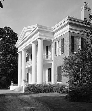
Natchez National Historical Park commemorates the history of Natchez, Mississippi, and is managed by the National Park Service.
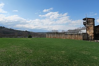
The Fort at Number 4 was a mid-18th century stockade fortification protecting Plantation Number 4, the northernmost British settlement along the Connecticut River in the Province of New Hampshire until after the French and Indian War. It was located in the present-day town of Charlestown, New Hampshire. A recreation of the fort, dating to 1960, now functions as an open-air museum, and was added to the New Hampshire State Register of Historic Places in July 2020.

Shepherd Hall, also known as Monument Place and formerly as Stone Mansion, is a historic house listed on the National Register of Historic Places in the city of Wheeling in the U.S. state of West Virginia. It is located in the Elm Grove area of Wheeling, Ohio County, West Virginia.
Manakin Sabot, consisting of the villages of Manakin and Sabot, is an unincorporated community in Goochland County, Virginia, United States. It is located northwest of Richmond in the Piedmont and is part of the Greater Richmond region.
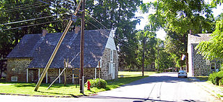
Historic Huguenot Street is located in New Paltz, New York, approximately 90 miles (140 km) north of New York City. The seven stone houses and several accompanying structures in the 10-acre National Landmark Historic District were likely built in the early 18th century by Huguenot settlers fleeing discrimination and religious persecution in France and what's now southern Belgium. After negotiating with the Esopus Indians, this small group of Huguenots settled on a flat rise on the banks of the Wallkill River in 1678. The settlers named the site in honor of Die Pfalz, the region of present-day Germany that had provided them temporary refuge before they came to America. Archaeological finds indicate that the immediate area settled by the Huguenots was occupied by Native Americans prior to European contact. The site is one of the oldest continuously inhabited settlements in the United States.

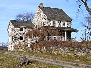
Greenwood Farm is a historic property and nature reserve located in Ipswich, Massachusetts, and owned by The Trustees of Reservations. The farm is 216 acres of gardens, pastures, meadows, woodlands and salt marsh and it features the PaineHouse, a First Period farmhouse constructed in 1694.

Fort Massapeag Archeological Site is a historic archaeological site at Sunset Park in Massapequa, New York. It is believed to be the site of a New Netherland trading post built in the mid-17th century to facilitate trade with local Native Americans, and possibly serve as a wampum factory. It was first excavated in the 1930s by a team including Ralph Solecki. It was declared a National Historic Landmark in 1993.

Jamestown Church, constructed in brick from 1639 onward, in Jamestown in the Mid-Atlantic state of Virginia, is one of the oldest surviving building remnants built by Europeans in the original Thirteen Colonies and in the United States overall. It is now part of Historic Jamestown, and is owned by Preservation Virginia. There have been several sites and stages in the church's history, and its later tower is now the last surviving above-ground structure from the days when Jamestown was the capital of Virginia. The current structure, active as part of the Continuing Anglican movement, is still in use today. The ruins are currently being researched by members of the Jamestown Rediscovery project.

Norwichtown is a historic neighborhood in the city of Norwich, Connecticut. It is generally the area immediately north of the Yantic River between I-395 and Route 169.

The Crown Point Road, or the Crown Point Military Road, is a historic road built in 1759-60, mostly in what is now the United States state of Vermont. It was built by British Army and colonial militia forces to connect Fort Crown Point near the southern end of Lake Champlain to the Fort at Number 4 in what is now Charlestown, New Hampshire. It was the first major road in Vermont, spurring development along its route after the French and Indian War. Fragments of the road are still visible in largely period condition, or have been paved over, while others have disappeared into the forest. Sections of the road located in Weathersfield have been listed on the National Register of Historic Places.

The Yantic Falls Historic District encompasses a historic mill and associated worker housing on Yantic Street in Norwich, Connecticut. The 10-acre (4.0 ha) area includes a complex of mill buildings, mainly built in brick, and mill worker housing, also out of brick. The area's industrial history dates to the early 19th century. The district was listed on the National Register of Historic Places on June 28, 1972.
Okehocking Historic District, also known as the Okehocking Indian Land Grant Historic District, is a national historic district in Willistown Township, Chester County, Pennsylvania. It was listed on the National Register of Historic Places in 1993.

Pejepscot is a historical settlement first occupied by a subset of the Androscoggin Native Americans known as the Wabanaki. The region encompasses the current towns of Brunswick, Topsham and Harpswell, Maine in Sagadahoc and Cumberland counties and was first settled by English settlers in 1628.


