
Drumquin is a village and townland in County Tyrone, Northern Ireland. It lies between Omagh and Castlederg, on the banks of the Drumquin River (Fairywater). It is situated in the civil parishes of both Longfield West and Longfield East. The main part of the village is located in Longfield East, in the townland of Drumnaforbe, whilst Longfield West is where its namesake townland Drumquin is located. Drumquin is in the historic barony of Omagh West.

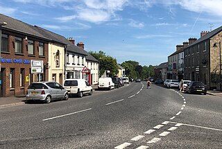
Ballymagorry or Ballymagory is a small village and townland in County Tyrone, Northern Ireland. It is west of Artigarvan and 5 kilometres (3.1 mi) north of Strabane. In the 2001 Census it had a population of 565. It lies within the Strabane District Council area and lies on the River Glenmornan.
Donaghmore is a village, townland and civil parish in County Tyrone, Northern Ireland, about five kilometres (3 mi) north-west of Dungannon. In the 2011 Census it had a population of 1,122 people. The village is beside the River Torrent, formerly known as the Torrent Flow.

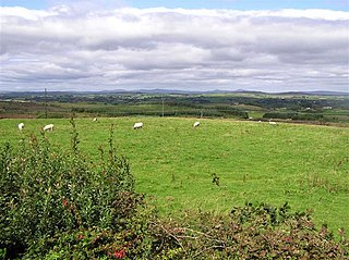
Dooish is a village and townland near Drumquin in County Tyrone, Northern Ireland. The townland is situated in the historic barony of Omagh West and the civil parish of Longfield West and covers an area of 845 acres. In the 2001 Census it had a population of 93 people. It lies within the Omagh District Council area.

Clady is a small village and townland in County Tyrone, Northern Ireland. It lies about 4 miles from Strabane on the River Finn and borders the Republic of Ireland. In the 2011 Census it had a population of 538 people. It is within Urney civil parish and the former barony of Strabane Lower. In local government it is part of the Derry City and Strabane District Council. The townland covers an area of 173 acres.

Brackaville or Bracaville is a village and townland near Coalisland in County Tyrone, Northern Ireland. It is situated in the historic barony of Dungannon Middle and the civil parish of Donaghenry and covers an area of 235 acres on the western side of Lough Neagh.
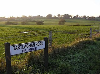
Drumkee is a townland in the southeast of County Tyrone, Northern Ireland. It is directly south of the area presently known as Coalisland and east, and slightly north, of Dungannon. It is situated in the historic barony of Dungannon Middle and the civil parish of Killyman and covers an area of 285 acres. The barony's tax records dated 1666 list two families living in Drumkee.

Dergalt is a townland in County Tyrone, Northern Ireland. It is situated in the historic barony of Strabane Lower and the civil parish of Camus and covers an area of 488 acres. United States president Woodrow Wilson's ancestral home is located in the townland.

Carnteel ) is a hamlet, townland and civil parish, about 2 miles northeast of Aughnacloy in County Tyrone, Northern Ireland. It is situated in the historic barony of Dungannon Lower.
Cavanakeeran is a townland in County Tyrone, Northern Ireland. It is situated in the historic barony of Dungannon Middle and the civil parish of Pomeroy and covers an area of 894 acres. The town of Pomeroy itself is situated in Cavanakeeran.

Derrytresk is a townland outside Coalisland, County Tyrone, Northern Ireland and is close to the shores of Lough Neagh. It is situated in the historic barony of Dungannon Middle and the civil parish of Clonoe and covers an area of 1020 acres. Derrytresk consists of sub-townlands: Derryvarne, Derrykiltena and Derrynahaskila.

Donaghey is a small village and townland roughly halfway between Cookstown and Dungannon, just off the A29, in County Tyrone, Northern Ireland.

Urney is a townland and civil parish in County Tyrone, Northern Ireland. Both townland and parish are situated in the historic barony of Strabane Lower. It lies within the Derry City and Strabane area.
Bullock Park is a townland in County Tyrone, Northern Ireland. It is situated in the historic barony of Omagh West and the civil parish of Longfield West and covers an area of 398 acres.
Crannogue is a townland in County Tyrone, Northern Ireland. It is situated in the historic barony of Dungannon Middle and the civil parish of Pomeroy and covers an area of 759 acres.
Derryloughan is a townland in County Tyrone, Northern Ireland. It lies on the southwest corner of Lough Neagh, 4 miles from Coalisland. It is situated in the historic barony of Dungannon Middle and the civil parish of Clonoe and covers an area of 1751 acres.
Flushtown is a townland in County Tyrone, Northern Ireland. It is situated in the historic barony of Strabane Lower and the civil parish of Urney and covers an area of 116 acres.
Fort-town is a townland in County Tyrone, Northern Ireland. It is situated in the historic barony of Strabane Lower and the civil parish of Urney and covers an area of 57 acres.
Gallany is a townland in County Tyrone, Northern Ireland. It is situated in the historic barony of Strabane Lower and the civil parish of Urney and covers an area of 296 acres.
Donnygowen is a townland in County Tyrone, Northern Ireland. It is situated in the historic barony of Strabane Lower and the civil parish of Urney and covers an area of 53 acres. The village of Clady is situated in the townlands of Clady and Donnygowen.
