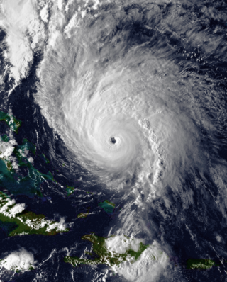
Hurricane Hortense was the first tropical cyclone to make landfall in Guadeloupe and Puerto Rico since Hurricane Hugo in 1989, and the second most intense hurricane during the 1996 Atlantic hurricane season. The eighth tropical cyclone, eighth named storm, and sixth hurricane of the season. Hortense developed on September 3 from a tropical wave in the central Atlantic Ocean. Initially a tropical depression, it headed westward without significant strengthening for four days due to unfavorable upper-level winds. While nearing the Lesser Antilles upper-level winds decreased, allowing the depression to become Tropical Storm Hortense on September 7. Hortense crossed Guadeloupe on September 8 and entered the Caribbean Sea. By on the following day, it was upgraded to a hurricane while curving northwestward. Hortense made landfall in Puerto Rico on September 9 and brushed the Dominican Republic shortly thereafter. After re-entering the Atlantic, Hortense began to substantially strengthen and peaked as a 140 mph (220 km/h) Category 4 hurricane early on September 13. Thereafter, the storm steadily weakened as it tracked rapidly north-northeastward. Early on September 15, Hortense made landfall in Nova Scotia as a minimal Category 1 hurricane. It quickly weakened further to a tropical storm before re-entering the Atlantic to the south of Newfoundland. Late on September 15, Hortense transitioned into an extratropical cyclone and subsequently merged with a frontal system about 24 hours later.

The 2001 Atlantic hurricane season was a fairly active Atlantic hurricane season that produced 17 tropical cyclones, 15 named storms, nine hurricanes, and four major hurricanes. The season officially lasted from June 1, 2001, to November 30, 2001, dates which by convention limit the period of each year when tropical cyclones tend to form in the Atlantic Ocean basin. The season began with Tropical Storm Allison on June 4, and ended with Hurricane Olga, which dissipated on December 6. The most intense storm was Hurricane Michelle, which attained Category 4 strength on the Saffir–Simpson Hurricane Scale.

The 1991 Atlantic hurricane season was the first season since 1984 in which no hurricanes developed from tropical waves, which are the source for most North Atlantic tropical cyclones. The hurricane season officially began on June 1, and ended on November 30. It was the least active in four years due to higher than usual wind shear across the Atlantic Ocean. The first storm, Ana, developed on July 2 off the southeast United States and dissipated without causing significant effects. Two other tropical storms in the season – Danny and Erika – did not significantly affect land. Danny dissipated east of the Lesser Antilles, and Erika passed through the Azores before becoming extratropical. In addition, there were four non-developing tropical depressions. The second depression of the season struck Mexico with significant accompanying rains.

The 2006 Atlantic hurricane season was the least active since 1997 as well as the first season since 2001 in which no hurricanes made landfall in the United States, and was the first since 1994 in which no tropical cyclones formed during October. Following the intense activity of 2003, 2004, and 2005, forecasters predicted that the 2006 season would be only slightly less active. Instead, it turned out to be a below average season, as activity was slowed by a rapidly forming moderate El Niño event, the presence of the Saharan Air Layer over the tropical Atlantic, and the steady presence of a robust secondary high-pressure area to the Azores High centered on Bermuda. There were no tropical cyclones after October 2.

Hurricane Charley was the second hurricane to threaten the East Coast of the United States within a year's timeframe, after Hurricane Gloria of 1985. The third tropical storm and second hurricane of the season, Charley formed as a subtropical low on August 13 along the Florida panhandle. After moving off the coast of South Carolina, the system transitioned into a tropical cyclone and intensified into a tropical storm on August 15. Charley later attained hurricane status before moving across eastern North Carolina. It gradually weakened over the north Atlantic Ocean before transitioning into an extratropical cyclone on August 20. Charley's remnants remained identifiable for over a week, until after crossing Ireland and Great Britain they dissipated on August 30.

Hurricane Gabrielle was a North Atlantic hurricane that caused flooding in both Florida and Newfoundland in September 2001. It developed in the Gulf of Mexico on the same day as the September 11 attacks; after the attacks, flights were canceled nationwide for two days, and when Gabrielle struck Florida on September 14, it caused a day of additional cancellations. The storm moved ashore with winds of 70 mph (110 km/h) near Venice, a city located south of the Tampa Bay area. The combination of the winds and heavy rainfall, which peaked at 15.1 in (380 mm) in Parrish, left 570,000 customers without power along the west coast and 126,000 customers without power on the east coast. The storm caused about $230 million (2001 USD) in damage in Florida. In the Gulf of Mexico, high waves contributed to two deaths, one of which was indirect; there was also a death due to flooding in Winter Haven.

Hurricane Felix caused severe beach erosion along the East Coast of the United States in August 1995. The seventh tropical cyclone, sixth named storm, and third hurricane of the 1995 Atlantic hurricane season, Felix was also the strongest hurricane in the Atlantic Ocean since Category 5 Hurricane Andrew in 1992. It developed from a tropical wave in the eastern Atlantic Ocean on August 8, and slowly intensified, reaching hurricane status on August 11. Under favorable conditions, Felix began to rapidly deepen while curving northwestward. Late on August 12, Felix peaked as a low-end Category 4 hurricane. However, it soon weakened rapidly to a Category 1 hurricane. Less than three days later, Felix passed only 75 mi (120 km) southeast of Bermuda. Although it also posed a threat to the East Coast of the United States, Felix curved northward and then east-northeastward while remaining offshore, thereby avoiding landfall. Felix briefly threatened Bermuda again, but weakened to a tropical storm and turned back to the northeast on August 20. It accelerated east-northeastward, and passed a short distance offshore of Newfoundland, where Felix transitioned into an extratropical storm on August 22.
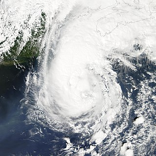
Hurricane Gustav was a Category 2 hurricane that paralleled the East Coast of the United States in September 2002 during the 2002 Atlantic hurricane season. It was the seventh named storm and first hurricane of the season. Initially a subtropical depression north of the Bahamas, Gustav passed just to the east of the Outer Banks, North Carolina as a tropical storm before traveling northeastward, making two landfalls in Atlantic Canada as a Category 1 hurricane. The storm was responsible for one death and $100,000 in damage, mostly in North Carolina. The interaction between Gustav and a non-tropical system produced strong winds that caused an additional $240,000 (2002 USD) in damage in New England, but this damage was not directly attributed to the hurricane.
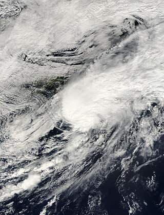
Tropical Storm Helene was a long-lived tropical cyclone that oscillated for ten days between a tropical wave and a 70 mph (110 km/h) tropical storm. It was the twelfth tropical cyclone and eighth tropical storm of the 2000 Atlantic hurricane season, forming on September 15 east of the Windward Islands. After degenerating into a tropical wave, the system produced flooding and mudslides in Puerto Rico. It reformed into a tropical depression on September 19 south of Cuba, and crossed the western portion of the island the next day while on the verge of dissipation. However, it intensified into a tropical storm in the Gulf of Mexico, reaching its peak intensity while approaching the northern Gulf Coast.
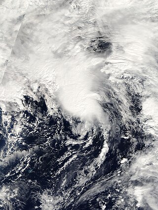
Subtropical Storm Nicole was the first subtropical storm to receive a name using the standard hurricane name list that did not become a tropical cyclone. The fifteenth tropical or subtropical cyclone and fourteenth named storm of the 2004 Atlantic hurricane season, Nicole developed on October 10 near Bermuda from a broad surface low that developed as a result of the interaction between an upper level trough and a decaying cold front. The storm turned to the northeast, passing close to Bermuda as it intensified to reach peak winds of 50 mph (80 km/h) on October 11. Deep convection developed near the center of the system as it attempted to become a fully tropical cyclone. However, it failed to do so and was absorbed by an extratropical cyclone late on October 11.

Hurricane Florence was the first North Atlantic hurricane to produce hurricane-force winds on the island of Bermuda since Hurricane Fabian in September 2003. The seventh tropical storm and second hurricane of the 2006 Atlantic hurricane season, Florence developed from a tropical wave in the eastern Atlantic Ocean on September 3. Due to unfavorable conditions, the system failed to organize initially, and as a result, the storm grew to an unusually large size. After several days, Florence encountered an area of lesser wind shear and intensified into a hurricane on September 10. It passed just west of Bermuda while recurving northeastward, and on September 13 it transitioned into an extratropical cyclone.

Tropical Storm Dean was a strong tropical storm that affected at least twelve islands along its path from the tropical Atlantic Ocean to east of Atlantic Canada in August 2001. Dean developed from a tropical wave on August 22 over the Lesser Antilles, and was initially predicted to intensify further to reach hurricane status. However, strong wind shear quickly weakened Dean to cause it to dissipate on August 23. The remnants turned northward, and redeveloped on August 26 to the north of Bermuda. Located over warm waters and in an area of favorable conditions, Dean steadily strengthened while moving to the northeast, and peaked just below hurricane status on August 27 about 465 miles (748 km) southwest of Newfoundland. The storm subsequently weakened over cooler waters, and became extratropical on August 28.

Hurricane Dean was a strong tropical cyclone that brought minor effects the United States and Atlantic Canada offshore in early August 1989. The fourth named storm and second hurricane of the 1989 Atlantic hurricane season, Dean formed on July 31 and reached tropical storm status the following day east of the Leeward Islands. Dean brushed the northern Leeward Islands as a Category 1 hurricane on the Saffir–Simpson Hurricane Scale, bringing light rain but producing no damage, before turning northward and striking Bermuda as a Category 2 hurricane. It continued northward before making landfall in southeastern Newfoundland.
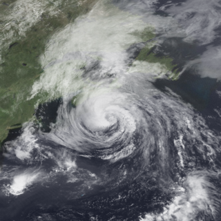
Hurricane Bertha caused minor damage in the United States, Bermuda, and Atlantic Canada in July and August 1990. The third tropical cyclone, second named storm, and first hurricane of the 1990 Atlantic hurricane season, Bertha developed from a frontal low pressure area offshore of North Carolina on July 24. Initially subtropical, it slowly acquired tropical characteristics while tracked southeast and then southwestward. By early on July 27, the cyclone was re-classified as a tropical depression. Following its transition, the depression intensified and was upgraded to Tropical Storm Bertha on July 28. The storm then curved northeastward and rapidly strengthened. Bertha became a hurricane early on July 29, though it weakened back to a tropical storm later that day. On the following day, Bertha re-intensified into a hurricane and peaked as an 80 mph (130 km/h) Category 1 hurricane on July 31.

Tropical Storm Chantal was a short-lived tropical storm that affected Bermuda in its formative stages and caused flooding and gusty winds in Newfoundland while extratropical. The third named storm of the 2007 Atlantic hurricane season, Chantal developed on July 31 from non-tropical origins between Bermuda and Cape Cod, and with favorable conditions, the storm rapidly attained peak winds of 50 mph (80 km/h). The storm accelerated northeastward over an area of progressively colder water temperatures, and after a decrease in convection the National Hurricane Center ceased issuing advisories as Chantal began undergoing extratropical transition early on August 1. Shortly thereafter, the extratropical remnant crossed over southeastern Newfoundland before tracking into the open waters of the north Atlantic Ocean. Prior to forming, the storm dropped moderate rainfall on Bermuda. Subsequent to becoming extratropical, the remnants of Chantal produced gusty winds and heavy precipitation across the Avalon Peninsula of Newfoundland, causing flooding and wind damage; insured damage totaled $25 million.

Hurricane Kyle was a Category 1 hurricane that caused heavy rain and flooding in Puerto Rico in its formative stage and brought hurricane-force winds to Nova Scotia while extratropical. The eleventh tropical storm and sixth hurricane of the 2008 Atlantic hurricane season, Kyle formed from a strong tropical disturbance that tracked across the northeastern Caribbean Sea in the third week of September. As a low pressure area, it moved slowly across Puerto Rico and Hispaniola, dumping torrential rains across those islands.

Hurricane Carol was one of only five Category 5 Atlantic hurricanes to not have its name be retired, the others being Esther, Edith, Emily and Lorenzo. Carol was also the strongest storm of the 1953 Atlantic hurricane season and the first Category 5 hurricane in the Atlantic basin since the 1944 Great Atlantic Hurricane. Carol is also the first named storm to attain Category 5 status. Carol developed on August 28 off the west coast of Africa, although the Weather Bureau did not initiate advisories until five days later. On September 2, Carol attained hurricane status, based on a ship report. It moved northwestward, attaining peak winds of 160 mph (260 km/h), based on reports from the Hurricane Hunters. After weakening, it brushed Bermuda and turned northeastward near New England, passing west of Nova Scotia before making landfall near Saint John, New Brunswick on September 7. While crossing Atlantic Canada, Carol became an extratropical cyclone, which dissipated on September 9 southwest of Greenland.

Hurricane Teddy was a large and powerful Cape Verde hurricane that was the fifth-largest Atlantic hurricane by diameter of gale-force winds recorded. Teddy produced large swells along the coast of the Eastern United States and Atlantic Canada in September 2020. The twentieth tropical depression, nineteenth named storm, eighth hurricane, and second major hurricane of the record-breaking 2020 Atlantic hurricane season, Teddy initially formed from a tropical depression that developed from a tropical wave on September 12. Initially, the depression's large size and moderate wind shear kept it from organizing, but it eventually intensified into Tropical Storm Teddy on September 14. After steadily intensifying for about a day, the storm rapidly became a Category 2 hurricane on September 16 before westerly wind shear caused a temporary pause in the intensification trend. It then rapidly intensified again on September 17 and became a Category 4 hurricane. Internal fluctuations and eyewall replacement cycles then caused the storm to fluctuate in intensity before it weakened some as it approached Bermuda. After passing east of the island as a Category 1 hurricane on September 21, Teddy restrengthened back to Category 2 strength due to baroclinic forcing. It weakened again to Category 1 strength the next day before becoming post-tropical as it approached Atlantic Canada early on September 23. It then weakened to a gale-force low and made landfall in Nova Scotia with sustained winds of 65 mph (105 km/h). The system weakened further as it moved northward across eastern Nova Scotia and then the Gulf of St. Lawrence, before being absorbed by a larger non-tropical low early on September 24, near eastern Labrador.
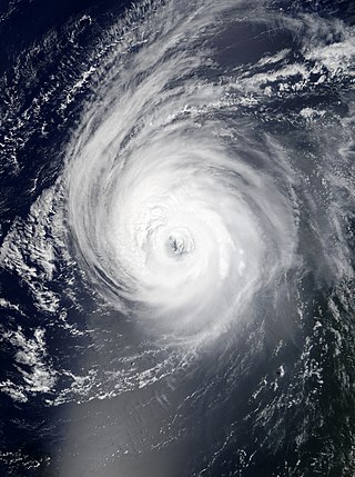
Hurricane Larry was a strong and long-lived Cape Verde hurricane that became the first hurricane to make landfall in Newfoundland since Igor in 2010. The twelfth named storm, fifth hurricane, and third major hurricane of the 2021 Atlantic hurricane season, Larry originated from a tropical wave that emerged off the coast of Africa and organized into a tropical depression on August 31. The next day, the depression developed into a tropical storm, receiving the name Larry. The storm moved quickly across the far eastern tropical Atlantic, where it strengthened into a Category 1 hurricane the morning of September 2. Then, after undergoing a period of rapid intensification, Larry became a major Category 3 hurricane early on September 4. After churning for several days as a strong hurricane in the open ocean, Larry made landfall in Newfoundland on September 11, as a Category 1 hurricane. Later that day, Larry became an extratropical cyclone. Finally, on September 13, Larry was absorbed by a larger extratropical cyclone near Greenland.


