
The National Register of Historic Places is a United States federal official list of places and sites considered worthy of preservation. In the state of Massachusetts, there are over 4,300 listings, representing about 5% of all NRHP listings nationwide and the second-most of any U.S. state, behind only New York. Listings appear in all 14 Massachusetts counties.
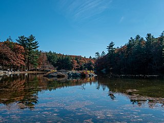
Breakheart Reservation is a public recreation area covering 652 acres (264 ha) in the towns of Saugus and Wakefield, Massachusetts. The reservation features a hardwood forest, two freshwater lakes, a winding stretch of the Saugus River, and scenic views of Boston and rural New England from rocky hilltops. The park is managed by the Massachusetts Department of Conservation and Recreation.

North Uxbridge is a village and a post office in the town (township) of Uxbridge in Worcester County, Massachusetts, United States. The postal zip code is 01538. It is classified as a community or populated place located at latitude 42.088 and longitude -71.641 and the elevation is 266 feet (81 m). North Uxbridge appears on the Uxbridge U.S. Geological Survey Map. Worcester County is in the Eastern time zone and observes DST. North Uxbridge is located approximately 36 miles west-southwest of Boston, and 15 miles southeast of Worcester. The town meeting in 1885 set aside North Uxbridge as a "special district", since its population had exceeded 1000 people. North Uxbridge appeared as a separate Census tract in the 1960 census, with a population of 1882. In 2013, an Uxbridge DIY show, The Garage, with Steve Butler, went worldwide from Steve's garage in North Uxbridge.

Morton Street is a street in southern Boston, Massachusetts, United States. It extends from the southeastern end of the Arborway in Jamaica Plain to Washington Street in the Lower Mills Village of Dorchester. Most of the road is a connecting parkway, signed as part of Massachusetts Route 203, that provides access to Boston's Emerald Necklace of parks. That portion of the road was listed on the National Register of Historic Places in 2005.

The Neponset Valley Parkway is a historic parkway in southern Boston and Milton, Massachusetts, United States. It is a connecting parkway in the Greater Boston area's network, providing a connection between the Blue Hills Reservation, Neponset River Reservation, and the Stony Brook Reservation. The parkway was constructed between 1898 and 1929 with design assistance from Charles Eliot and the Olmsted Brothers. It was listed on the National Register of Historic Places in 2005.

The Truman Parkway is a historic parkway in Milton and southern Boston, Massachusetts. It runs along the southern boundary of a portion of the Neponset River Reservation and serves as a connection between the Neponset Valley Parkway and the Blue Hills Parkway. The parkway was built in 1931 and added to the National Register of Historic Places in 2005.

The Veterans of Foreign Wars Parkway is a historic parkway in Boston, Massachusetts. The southern terminus of the parkway is at Washington Street at the Dedham-West Roxbury border, from where it travels north and then east, ending at a junction with Centre Street, near the Arnold Arboretum. The highway is almost entirely contained within the West Roxbury neighborhood, although it passes through part of the Chestnut Hill neighborhood near its junction with the West Roxbury Parkway. Most of its length, from Spring Street in West Roxbury to its eastern end, is administered by the Massachusetts Department of Conservation and Recreation (DCR), a successor to the Metropolitan District Commission (MDC) which oversaw the road's construction. The parkway was built in stages between 1930 and 1942, and was designed to provide a parkway connection from the Upper Charles River Reservation to other MDC parks via the West Roxbury Parkway. The DCR portion of the road was listed on the National Register of Historic Places in 2005. The road formerly carried the designation for U.S. Route 1.
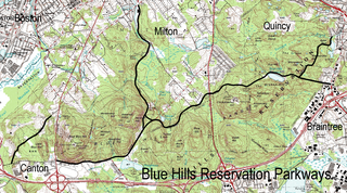
The Blue Hills Reservation Parkways are a network of historic parkways in and around the Blue Hills Reservation, a Massachusetts state park south of Boston, Massachusetts. It consists of six roadways that provide circulation within the park, and that join the park to two connecting parkways, the Blue Hills Parkway and the Furnace Brook Parkway. The roadway network was designed by Charles Eliot in the 1890s, except for Green Street, which was added to the network in the 1940s. The parkways were added to the National Register of Historic Places in 2003.

Charlton Center Historic District is an historic district roughly on Main Street from Mugget Hill Road to Masonic Home Road and adjacent roads in Charlton, Massachusetts. The district, which encompasses the historic center of the town, includes the first architect-designed building in the center, the Shingle style Overlook Hotel designed by Worcester architect George H. Clemence, as well as the 1905 Colonial Revival Town Hall designed by Frost, Briggs & Chamberlain. The town hall site is also home to a number of memorials to the town's military.

The Fells Connector Parkways are a group of historic parkways in the cities of Malden and Medford, Massachusetts, suburbs north of the city of Boston. The three parkways, The Fellsway, Fellsway West, and Fellsway East serve to provide access from the lower portion of the Mystic River Reservation to the Middlesex Fells Reservation. The latter two parkways continue northward, providing access to the interior of the Fells and providing a further connection to Lynn Fells Parkway. Significant portions of these parkways south of the Fells, which were among the first connecting parkways designed to be part of the Metropolitan Park System of Greater Boston by Charles Eliot, were listed on the National Register of Historic Places in 2003.

The Lars Petterson-Silas Archer Three-Decker is a historic triple decker house in Worcester, Massachusetts. The house was built c. 1920, and was listed on the National Register of Historic Places as a good example of Colonial Revival architecture from that period. Some of those features have subsequently been lost.

The Windsor Court Historic District is a residential historic district in Southbridge, Massachusetts, United States. It is a collection of five three-family residences located on Windsor Court and adjacent North Street that were built by the American Optical Company between 1915 and 1917 to provide worker housing. The district was listed on the National Register of Historic Places in 1989.

The Green Hill Park Shelter is a historic picnic shelter in Green Hill Park, the largest city park of Worcester, Massachusetts. It was designed by architect George H. Clemence, and built in 1910-11. The building is the most architecturally sophisticated park pavilion in the city, and was listed on the National Register of Historic Places in 1980.

The Building at 38–42 Worcester Street is a historic six-unit triple decker in Southbridge, Massachusetts. Built sometime between 1878 and 1898, it has features influenced by the area's then-growing French Canadian immigrant population, including its outside porches. The building was listed on the National Register of Historic Places in 1989.

The Maple Street Historic District consists of a cluster of ten similar worker cottages on Maple Street in Southbridge, Massachusetts. They were built as part of an effort by the locally important American Optical Company to improve the quality of its worker housing in the 1910s. The district was listed on the National Register of Historic Places in 1989.

Blue Hills Parkway is a historic parkway that runs in a straight line from a crossing of the Neponset River, at the south border of Boston to the north edge of the Blue Hills Reservation in Milton, Massachusetts. It was built in 1893 to a design by the noted landscape architect, Charles Eliot, who is perhaps best known for the esplanades along the Charles River. The parkway is a connecting road between the Blue Hills Reservation and the Neponset River Reservation, and was listed on the National Register of Historic Places in 2003.

Hammond Pond Parkway is a historic parkway in Chestnut Hill, Massachusetts. The road, built in 1932, extends 2 miles (3.2 km) from Hobart Road in Newton to Horace James Circle in Brookline, where it joins the West Roxbury Parkway. It was designed by Charles Eliot and the Olmsted Brothers to provide a parkway setting that provided access from Brookline, Newton, and the western portions of Boston to the southern parks of the Emerald Necklace. The parkway was listed on the National Register of Historic Places in 2004.

West Roxbury Parkway is a historic parkway running from Washington Street in Boston, Massachusetts, where the Enneking Parkway runs south, to Horace James Circle in Chestnut Hill, where it meets the Hammond Pond Parkway. The parkway serves as a connector between Stony Brook Reservation and Hammond Pond Reservation. West Roxbury Parkway was built between 1919 and 1929 and added to the National Register of Historic Places in 2006. The parkway is distinctive in the roadway system developed by the Metropolitan District Commission beginning around the turn of the 20th century in that it was built in collaboration with the City of Boston, and is maintained by the city.

The Manchaug Village Historic District is a historic district encompassing the 19th century industrial village center of Manchaug in Sutton, Massachusetts. Developed in the 1820s around textile mills on the Mumford River, it was the largest industrial area in Sutton, with at least three mill complexes in operation. The district is centered on the junction of Main Street with Manchaug, Putnam Hill, and Whitins Roads.

The Indian Hill School is a historic school building at 155 Ararat Street in Worcester, Massachusetts. Built in 1924, it is a good local example of Tudor Revival architecture. It served as a public school until 1981, after which it was converted to residential use. The building was listed on the National Register of Historic Places in 2022.


