Irvington, Iowa | |
|---|---|
 Irvington  Irvington | |
| Coordinates: 43°0′22″N94°11′42″W / 43.00611°N 94.19500°W | |
| Country | USA |
| State | Iowa |
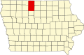
| County | Kossuth |
| Township | Irvington |
| Area | |
• Total | 1.01 sq mi (2.62 km2) |
| • Land | 1.01 sq mi (2.62 km2) |
| • Water | 0.00 sq mi (0.00 km2) |
| Elevation | 1,155 ft (352 m) |
| Population (2020) | |
• Total | 36 |
| • Density | 35.57/sq mi (13.74/km2) |
| Time zone | UTC-6 (Central (CST)) |
| • Summer (DST) | UTC-5 (CDT) |
| ZIP code | 50560 |
| Area code | 515 |
| FIPS code | 19-38955 |
| GNIS feature ID | 2585481 [2] |
Irvington is an unincorporated community and census-designated place (CDP) in Irvington Township, Kossuth County, Iowa, United States. [3] As of the 2020 census it had a population of 36.