Jefferson Avenue station

Last updated

Jefferson Avenue
MTA NYC logo.svg Staten Island Railway station (rapid transit)
Jefferson Avenue station - September 2020.jpg
Jefferson Avenue station in September 2020
General information
LocationJefferson Avenue and North Railroad Avenue
Midland Beach, Staten Island
Coordinates 40°35′02″N74°06′11″W / 40.5838°N 74.1030°W / 40.5838; -74.1030
Platforms2 side platforms
Tracks2
Construction
Structure type Embankment
Other information
Station code508
History
Opened1937 [lower-alpha 1]
Rebuilt19651968
Services
Preceding station MTA NYC logo.svg Staten Island Railway Following station
Dongan Hills
toward St. George
NYCS-bull-trans-SIR-Std.svg Grant City
toward Tottenville

The Jefferson Avenue station is a Staten Island Railway station between the neighborhoods of Grant City and Dongan Hills, in Staten Island, New York.

Contents

Station layout

The station opened in 1937. [lower-alpha 1] Prior to 1965, the Jefferson Avenue crossing was at grade level. It only had a single warning bell for approaching trains. In the mid-1960's, construction began on eliminating the crossings from Jefferson Avenue to New Dorp. The track was displaced onto South Railroad Avenue and the station as well as the crossing were temporarily relocated to Adams Avenue. Jefferson Avenue and the adjacent intersections were dropped below grade and the current station was built.

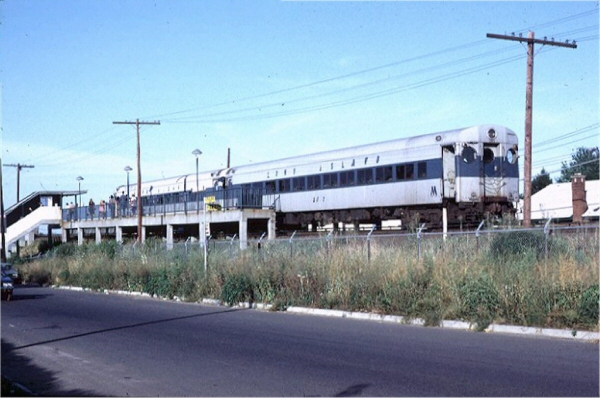
Currently, the station is located on an embankment at Jefferson Avenue and Railroad Avenue on the main line. This station has two side platforms. From north to south, Jefferson Avenue station begins the descent from the embankment to the open cut.

This is the only station on the Staten Island Railway that is named for the street it serves rather than the neighborhood. [1]

Platform
level
Side platform
Southbound NYCS-bull-trans-SIR-Std.svg toward Tottenville (Grant City)
NYCS-bull-trans-SIR-Std.svg rush hour express does not stop here
Northbound NYCS-bull-trans-SIR-Std.svg toward St. George (Dongan Hills)
NYCS-bull-trans-SIR-Std.svg AM rush express does not stop here →
Side platform
GroundStreet levelExit/entrance, buses

Exit

The only exit is at the northeast end, which leads to Jefferson Avenue. There is no station house. [2]

Related Research Articles

<span class="mw-page-title-main">Staten Island Railway</span> Rapid transit line in New York City

The Staten Island Railway (SIR) is a rapid transit line in the New York City borough of Staten Island. It is owned by the Staten Island Rapid Transit Operating Authority (SIRTOA), a subsidiary of the Metropolitan Transportation Authority, and operated by the New York City Transit Authority Department of Subways. SIR operates 24 hours a day, seven days a week, providing local service between St. George and Tottenville, along the east side of the island. There is currently only one line on the island, and there is no direct rail link between the SIR and the New York City Subway system, but SIR riders do receive a free transfer to New York City Transit bus and subway lines, and the line is included on official New York City Subway maps. Commuters on the railway typically use the Staten Island Ferry to reach Manhattan. The line is accessible from within the Ferry Terminal, and most of its trains are timed to connect with the ferry. In 2023, the system had a ridership of 6,151,400, or about 19,500 per weekday as of the fourth quarter of 2023.

<span class="mw-page-title-main">Avenue M station</span> New York City Subway station in Brooklyn

The Avenue M station, is a local station on the BMT Brighton Line of the New York City Subway. It is located in Midwood, Brooklyn, at Avenue M between East 15th and East 16th Streets. The station is served by the Q train at all times.

<span class="mw-page-title-main">St. George Terminal</span> Transit center in Staten Island, New York

St. George Terminal is a ferry, railway, bus, and park and ride transit center in the St. George neighborhood of Staten Island, New York City. It is located at the intersection of Richmond Terrace and Bay Street, near Staten Island Borough Hall, SIUH Community Park and Richmond County Supreme Court. St. George is a rare example of a rail-boat connection in the United States.

<span class="mw-page-title-main">Atlantic station (Staten Island Railway)</span>

Atlantic was a Staten Island Railway station in the neighborhood of Tottenville, Staten Island, New York. With the condition of the station having deteriorated after the 1990s, this station, and the Nassau station to the north, were replaced by a new station at Arthur Kill Road. When that station opened in January 2017, Atlantic station closed and subsequently demolished.

<span class="mw-page-title-main">Nassau station</span>

The Nassau station was a Staten Island Railway station located roughly between the neighborhoods of Tottenville and Charleston, in Staten Island, New York. The station was built sometime after 1924 in order to serve the Nassau Smelting & Refining Company, and had a siding so that freight could be transferred to and from the factory. The station platforms were extended in 1971 as part of the modernization of the rail line. However, the condition of the station deteriorated after the 1990s, and this station, along with the Atlantic station to the south, were replaced by a new station at Arthur Kill Road. When that station opened in January 2017, Nassau station closed. The station was subsequently demolished.

<span class="mw-page-title-main">Richmond Valley station</span> Staten Island Railway station

The Richmond Valley station is a Staten Island Railway station in the neighborhood of Richmond Valley, Staten Island, New York. Located at Richmond Valley Road and Amboy Road on the main line, the station is a mixture of open cut at the north end and grade level at the south end.

<span class="mw-page-title-main">Annadale station</span> Staten Island Railway station

The Annadale station is a Staten Island Railway station in the neighborhood of Annadale, Staten Island, New York.

<span class="mw-page-title-main">Eltingville station</span> Staten Island Railway station

The Eltingville station is an elevated Staten Island Railway station in the neighborhood of Eltingville, Staten Island, New York. It is located at Richmond Avenue on the main line.

<span class="mw-page-title-main">Great Kills station</span> Staten Island Railway station

The Great Kills station is a Staten Island Railway station in the neighborhood of Great Kills, Staten Island, New York. It is located on an open cut west of Giffords Lane and Amboy Road on the main line. It has two side platforms and turquoise blue canopies and walls.

<span class="mw-page-title-main">Bay Terrace station</span> Staten Island Railway station

The Bay Terrace station is a Staten Island Railway station in the neighborhood of Bay Terrace, Staten Island, New York.

<span class="mw-page-title-main">Oakwood Heights station</span> Staten Island Railway station

The Oakwood Heights station is a Staten Island Railway station in the neighborhood of Oakwood, Staten Island, New York.

<span class="mw-page-title-main">New Dorp station</span> Staten Island Railway station

The New Dorp station is a Staten Island Railway station in the neighborhood of New Dorp, Staten Island, New York. The station became fully compliant with the Americans with Disabilities Act of 1990 in 2023.

<span class="mw-page-title-main">Grant City station</span> Staten Island Railway station

The Grant City station is a Staten Island Railway station in the neighborhood of Grant City, Staten Island, New York.

<span class="mw-page-title-main">Dongan Hills station</span> Staten Island Railway station

The Dongan Hills station is a Staten Island Railway station in the neighborhood of Dongan Hills, Staten Island, New York.

<span class="mw-page-title-main">Old Town station (Staten Island Railway)</span> Staten Island Railway station

The Old Town station is a Staten Island Railway station in the neighborhood of Old Town, Staten Island, New York.

<span class="mw-page-title-main">Grasmere station</span> Staten Island Railway station

The Grasmere station is a Staten Island Railway station in the neighborhood of Grasmere, Staten Island, New York. It is located at Clove Road on the Main Line.

<span class="mw-page-title-main">Clifton station (Staten Island Railway)</span> Staten Island Railway station

The Clifton station is a Staten Island Railway station in the neighborhood of Clifton, Staten Island, New York. This station was the original terminal of the Staten Island Railway from 1860 until 1886. The station was known as Vanderbilt's Landing, and was used as a transfer point for passengers going to Manhattan via ferries to South Ferry.

<span class="mw-page-title-main">Tompkinsville station</span> Staten Island Railway station

The Tompkinsville station is a Staten Island Railway station in the neighborhood of Tompkinsville, Staten Island, New York. It is located at Victory Boulevard and Bay Street on the railroad's main line. This is one of two stations on the line that require fare payment to enter or exit, the other being St. George.

<span class="mw-page-title-main">Elm Park station (Staten Island Railway)</span>

Elm Park is a station on the abandoned North Shore Branch of the Staten Island Railway (SIR). The station is located in an open cut under the Bayonne Bridge approach in Elm Park, Staten Island, at Morningstar Road between Innis Street and Newark Avenue. It has two tracks and two side platforms. The station is approximately 3.9 miles (6.3 km) from the Saint George terminal of the SIR.

<span class="mw-page-title-main">History of the Staten Island Railway</span>

The Staten Island Railway (SIR) is the only rapid transit line in the New York City borough of Staten Island and is operated by the Staten Island Rapid Transit Operating Authority, a unit of the Metropolitan Transportation Authority. The railway was historically considered a standard railroad line, but today only the western portion of the North Shore Branch, which is disconnected from the rest of the SIR, is used by freight and is connected to the national railway system.

References

  1. 1 2 The opening date for this station can be approximated using contemporaneous maps and tickets. This ticket from 1935 [lower-alpha 2] shows that the Jefferson Avenue station has not yet opened. A map of the Staten Island Rapid Transit Railway Company dated to January 11, 1937 shown here: [lower-alpha 3] does not show the Old Town, Jefferson Avenue or Lake Avenue stations. However, [lower-alpha 4] another map with the same date shows these stations with a few additional modifications. It seems that the second map was a revised version of the first one. Presumably it was printed to correct the old information, which did not show these stations. Finally, this ticket from 1938: [lower-alpha 5] does show the station.
  2. "Staten Island Rapid Transit Ticket from July 31, 1935 No. A 9508". Flickr. Staten Island Rapid Transit Railway Company. November 19, 2015. Retrieved December 24, 2017.
  3. "Staten Island Rapid Transit Railway Map 1937". Flickr. Staten Island Rapid Transit Railway Company. November 19, 2015. Retrieved December 24, 2017.
  4. "Staten Island Rapid Transit Railway Map 1937". Staten Island Rapid Transit Railway Company.{{cite web}}: Missing or empty |url= (help)
  5. "Staten Island Rapid Transit Ticket 1939 No. B 260510". Flickr. Staten Island Rapid Transit Railway Company. November 19, 2015. Retrieved December 24, 2017.
  1. "Subway Map" (PDF). Metropolitan Transportation Authority. September 2021. Retrieved September 17, 2021.
  2. "Map of NYC Subway Entrances". NYC Open Data. City of New York . Retrieved July 10, 2018.

Commons-logo.svg Media related to Jefferson Avenue (Staten Island Railway station) at Wikimedia Commons