The station prior to its insertion into an open cut
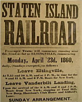
The station opened as Richmond on April 23, 1860, with the opening of the Staten Island Railway from Vanderbilt's Landing to Eltingville.[1][2] The station was named Richmond[3] as the station was on the border between Richmond and Oakwood. Afterwards, sometime around 1885 the station was renamed Court House.[4] The station was a flag stop.[5] The station was later renamed Oakwood,[6] and then finally Oakwood Heights after the other neighborhood on the border of the station. A 1909 timetable calls the station Oakwood Heights, but puts Court House in parentheses.[4]
Station layout
Northbound platform and tracks
The station is located on an open cut at Guyon Avenue and Railroad Avenue. It has two side platforms and beige painted walls. This station is used frequently by students of the nearby Monsignor Farrell High School.
Due to a partial platform collapse on the St. George-bound platform, certain doors on St. George-bound trains currently do not open here. On the 75-foot (23 m) R44s, the last car will not open its doors. On the 60-foot (18 m) R211s, the first three cars open entirely, while the fourth car only has the front three doors open, and the last car does not open at all.[7]
The north end has an overpass with two exits, one to Oak Avenue for the northbound platform, and the other to Cedarview Avenue for the southbound platform side. Another exit at the south end leads to Guyon Avenue, which is only currently accessible from the Tottenville-bound platform.[8]
This page is based on this Wikipedia article Text is available under the CC BY-SA 4.0 license; additional terms may apply. Images, videos and audio are available under their respective licenses.


