Rosebank station

Last updated

Rosebank
Former Staten Island Railway station
Chestnut Av overpass SIRR jeh.jpg
Approximate site of former Rosebank station, with ramp for former bridge across former track
General information
Location Rosebank, Staten Island
Coordinates 40°36′53″N74°04′13″W / 40.614639°N 74.070278°W / 40.614639; -74.070278 (Rosebank Station)
Line(s) South Beach Branch
Platforms2 side platforms
Tracks2
History
OpenedMarch 8, 1886;137 years ago (1886-03-08)
ClosedMarch 31, 1953;70 years ago (1953-03-31)
Former services
Preceding station Staten Island Railway Following station
Bachmann
toward Clifton
South Beach Branch Belair Road

Rosebank is a demolished station in the Rosebank neighborhood along the abandoned South Beach Branch of the Staten Island Railway. It had two tracks and two side platforms, and was located along Tilson Place between Virginia Avenue and St. Mary's Avenue. [1]

History

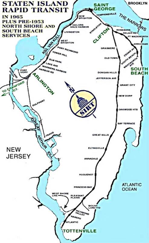
As part of a grade crossing elimination project on the South Beach Branch, the grade crossing at St. Mary's Avenue was eliminated, and the station was rebuilt in the fall of 1937. This structure remained in place until well after the branch's abandonment in 1953. There was an overpass at the new station connecting the two platforms. At Clifton Avenue, there was a pedestrian underpass which ran underground beneath the tracks that was built in 1937. This underpass was frequently used by students from Public School 13. The two buildings of P.S. 13 were later on replaced with one building, which stands on the South Beach Branch right-of-way. [1]

This station was abandoned when the SIRT discontinued passenger service on the South Beach Branch to Wentworth Avenue at midnight on March 31, 1953 because of city-operated bus competition. [2] [3] [4] [5]

Previously, south of the station at Hylan Boulevard, there was an overpass, that has been filled in since the line was abandoned. The Virginia Avenue trestle was demolished in 1999. [1]

There is also discussion of building a station nearby on the SIR Main Line which would bridge the longest gap between two stations (Grasmere and Clifton). This proposed station could be named Rosebank. [6]

Related Research Articles

<span class="mw-page-title-main">Staten Island Railway</span> Rapid transit line in New York City

The Staten Island Railway (SIR) is a rapid transit line in the New York City borough of Staten Island. It is owned by the Staten Island Rapid Transit Operating Authority (SIRTOA), a subsidiary of the Metropolitan Transportation Authority, and operated by the New York City Transit Authority Department of Subways. SIR operates 24 hours a day, seven days a week, providing local service between St. George and Tottenville, along the east side of the island. There is currently only one line on the island, and there is no direct rail link between the SIR and the New York City Subway system, but SIR riders do receive a free transfer to New York City Transit bus and subway lines, and the line is included on official New York City Subway maps. Commuters on the railway typically use the Staten Island Ferry to reach Manhattan. The line is accessible from within the Ferry Terminal, and most of its trains are timed to connect with the ferry. In 2022, the system had a ridership of 3,757,700, or about 15,000 per weekday as of the second quarter of 2023.

Arrochar is a neighborhood in northeastern Staten Island in New York City in the United States. It is located directly inland of Fort Wadsworth and South Beach, on the east side of Hylan Boulevard south of the Staten Island Expressway; the community of Grasmere borders it on the west. It is today primarily a neighborhood of one- and two-family homes and small businesses.

<span class="mw-page-title-main">Grasmere station</span> Staten Island Railway station

The Grasmere station is a Staten Island Railway station in the neighborhood of Grasmere, Staten Island, New York. It is located at Clove Road on the Main Line.

The Mayer Bachmann Brewery (1851–1881) was the largest of a half-dozen breweries on Staten Island, New York, before its destruction by fire. After rebuilding, it operated as the Bachmann Brewery and then the Bachmann Bechtel Brewery until 1919.

Arlington was a station on the abandoned North Shore Branch of the Staten Island Railway, in Staten Island, New York. Located in an open-cut 5.2 miles (8.4 km) from the St. George Terminal, it had two tracks and one island platform. For a few years before its closure in 1953, it was the western terminus of the North Shore Line; before then, the terminus was the Port Ivory station to the west, though most trains terminated at Arlington. It was located in the Arlington and Mariners Harbor sections of Staten Island, near the Arlington Yard, under the South Avenue overpass, between Arlington Place and Brabant Street.

Wentworth Avenue was a station on the demolished South Beach Branch of the Staten Island Railway. It had one side platform served by one track and was located at Oceanside Avenue and Wentworth Avenue, which has been restored to a Bluebelt wetland since its acquisition by the NYC DEP as part of the South Beach Drainage Plan. Much of the area along the coast nearby has been similarly acquired by city or state agencies in order to allow for storm protection since the devastation wrought by Hurricane Sandy.

<span class="mw-page-title-main">Belair Road station</span>

Belair Road is a demolished station on the abandoned South Beach Branch of the Staten Island Railway. It had two side platforms and two tracks, and was located at Vermont Avenue, between Belair Road & St. Johns Avenue. This station served the US Quarantine station, which was one block to the east.

Cedar Avenue was a station on the demolished South Beach Branch of the Staten Island Railway. It had two tracks and two side platforms and was located at Cedar Avenue and Railroad Avenue. It opened in 1931, and closed in 1953.

Arrochar was a station on the demolished South Beach Branch of the Staten Island Railway. It had two side platforms and two tracks and was located at Major Avenue. The station was able to platform two train cars.

<span class="mw-page-title-main">Fort Wadsworth station</span>

Fort Wadsworth was a station on the demolished South Beach Branch of the Staten Island Railway, near the historic Fort Wadsworth. It had two side platforms and two tracks, and was located at Fingerboard Road.

<span class="mw-page-title-main">Port Richmond station</span>

Port Richmond is a station on the abandoned North Shore Branch of the Staten Island Railway. Located in Port Richmond on a concrete trestle at Park Avenue and Church Street, it has two tracks and an island platform. The station is located approximately 3 miles (4.8 km) from Saint George Terminal.

Harbor Road was a station on the abandoned North Shore Branch of the Staten Island Railway in Mariners Harbor, Staten Island, New York. The station, located under the overpass at the highest point of Harbor Road, was built in an open-cut with two tracks and one island platform. It was located 4.9 miles (7.9 km) from the Saint George terminal. The station was opened during the SIRT grade crossing elimination project of 1935 – 1937. It closed on March 31, 1953, along with the South Beach Branch and the rest of the North Shore Branch. The station was demolished in 2004 during a reconstruction of the rail system for reactivated freight service by the nearby Howland Hook Marine Terminal.

<span class="mw-page-title-main">Livingston station (Staten Island Railway)</span>

Livingston is a former station on the abandoned North Shore Branch of the Staten Island Railway. Located north of Richmond Terrace at Bard Avenue in the Livingston section of Staten Island, it had two tracks and two side platforms. The site is 1.8 miles (2.9 km) from the Saint George terminal. Closed in 1953, the station was demolished, with few remnants of the site today.

<span class="mw-page-title-main">South Beach station</span> Former Staten Island Railway station in Staten Island, New York

South Beach was a station on the demolished South Beach Branch of the Staten Island Railway. It had two tracks and two side platforms, and was located at Sand Lane and Oceanside Avenue.

Bachmann was a station on the demolished South Beach Branch of the Staten Island Railway. Constructed in 1886 to serve the employees of Bachmann's Brewery, it had two tracks and two side platforms, and was located east of Tompkins Avenue, between Lynhurst and Chestnut Avenues. During a grade crossing elimination project on the South Beach Branch, the railroad closed and razed the stop in 1937, due to its proximity to the Rosebank station and the fact that the brewery never reopened after Prohibition. Well after the closure of the Bachmann station, the rest of the South Beach Branch was abandoned in 1953, because of city-operated bus competition.

Tompkins Avenue is a main artery in northeastern Staten Island New York City. It connects southern Tompkinsville in the north to northern Arrochar in the south, passing through the Fort Wadsworth, Rosebank, Shore Acres, Clifton, and Stapleton neighborhoods. It is mostly a residential street, though it also has commercial districts.

<span class="mw-page-title-main">South Beach Branch</span> Former railroad branch in Staten Island, New York

The South Beach Branch, also called the East Shore Sub-Division, is an abandoned branch of the Staten Island Railway in New York City, which operated along Staten Island's East Shore from Clifton to Wentworth Avenue. This 4.1-mile (6.6 km) double-tracked branch left the Main Line at 40°37′08″N74°04′18″W, south of the Clifton station, and lay to the east of the Main Line.

<span class="mw-page-title-main">North Shore Branch</span> Railroad branch in Staten Island, New York

The North Shore Branch is an abandoned branch of the Staten Island Railway in New York City, which operated along Staten Island's North Shore from Saint George to Port Ivory. The line continues into New Jersey via the Arthur Kill Vertical Lift Bridge to Aldene Junction in Cranford.

<span class="mw-page-title-main">History of the Staten Island Railway</span> Aspect of history surrounding the Staten Island Railway

The Staten Island Railway (SIR) is the only rapid transit line in the New York City borough of Staten Island and is operated by the Staten Island Rapid Transit Operating Authority, a unit of the Metropolitan Transportation Authority. The railway was historically considered a standard railroad line, but today only the western portion of the North Shore Branch, which is disconnected from the rest of the SIR, is used by freight and is connected to the national railway system.

References

  1. 1 2 3 "Gary Owen's SIRT Page". Gary Owen Land. March 31, 1953. Retrieved December 13, 2015.
  2. "Gary Owen SIRT Page Part Two". Gary Owen Land. April 20, 1937. Retrieved December 13, 2015.
  3. Pitanza, Marc (2015). Staten Island Rapid Transit Images of Rail. Arcadia Publishing. ISBN   978-1-4671-2338-9.
  4. Drury, George H. (1994). The Historical Guide to North American Railroads: Histories, Figures, and Features of more than 160 Railroads Abandoned or Merged since 1930. Waukesha, Wisconsin: Kalmbach Publishing. pp. 312–314. ISBN   0-89024-072-8.
  5. "The Old Order Passeth: Rails Surrender To Roads: Passenger Runs on Two Lines of SIRT Will End at Midnight". Staten Island Advance. March 31, 1953. Retrieved October 14, 2015.
  6. DAnna, Ed A. (May 15, 2008). "A rail station for Rosebank?". Staten Island Advance . Retrieved January 28, 2010.