New Dorp | |||||||||||||||||||||||||||||||||||||||||||||||||||||||||||||||
---|---|---|---|---|---|---|---|---|---|---|---|---|---|---|---|---|---|---|---|---|---|---|---|---|---|---|---|---|---|---|---|---|---|---|---|---|---|---|---|---|---|---|---|---|---|---|---|---|---|---|---|---|---|---|---|---|---|---|---|---|---|---|---|
Staten Island Railway station (rapid transit) | |||||||||||||||||||||||||||||||||||||||||||||||||||||||||||||||
General information | |||||||||||||||||||||||||||||||||||||||||||||||||||||||||||||||
Location | New Dorp Lane and North Railroad Avenue New Dorp, Staten Island | ||||||||||||||||||||||||||||||||||||||||||||||||||||||||||||||
Coordinates | 40°34′25″N74°07′02″W / 40.5736°N 74.1171°W | ||||||||||||||||||||||||||||||||||||||||||||||||||||||||||||||
Platforms | 2 side platforms | ||||||||||||||||||||||||||||||||||||||||||||||||||||||||||||||
Tracks | 2 | ||||||||||||||||||||||||||||||||||||||||||||||||||||||||||||||
Connections | NYCT Bus: S57, S76, S86 | ||||||||||||||||||||||||||||||||||||||||||||||||||||||||||||||
Construction | |||||||||||||||||||||||||||||||||||||||||||||||||||||||||||||||
Structure type | Open-cut | ||||||||||||||||||||||||||||||||||||||||||||||||||||||||||||||
Accessible | Yes | ||||||||||||||||||||||||||||||||||||||||||||||||||||||||||||||
Other information | |||||||||||||||||||||||||||||||||||||||||||||||||||||||||||||||
Station code | 510 | ||||||||||||||||||||||||||||||||||||||||||||||||||||||||||||||
History | |||||||||||||||||||||||||||||||||||||||||||||||||||||||||||||||
Opened | April 23, 1860 [1] | ||||||||||||||||||||||||||||||||||||||||||||||||||||||||||||||
Rebuilt | 1889, 1965–1968 | ||||||||||||||||||||||||||||||||||||||||||||||||||||||||||||||
Services | |||||||||||||||||||||||||||||||||||||||||||||||||||||||||||||||
| |||||||||||||||||||||||||||||||||||||||||||||||||||||||||||||||
| |||||||||||||||||||||||||||||||||||||||||||||||||||||||||||||||
|
The New Dorp station is a Staten Island Railway station in the neighborhood of New Dorp, Staten Island, New York. The station became fully compliant with the Americans with Disabilities Act of 1990 in 2023.
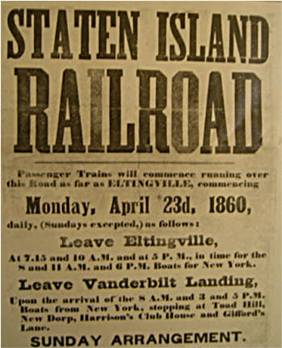
The station opened on April 23, 1860, with the opening of the Staten Island Railway from Vanderbilt's Landing to Eltingville. [1] [2] It was rebuilt in 1889 by real estate developers Hughes and Ross who sought to build a depot designed to attract potential homebuyers. The former stationhouse that was in use until the 1965-1968 grade crossing elimination [3] was moved to Historic Richmond Town, located at the three-way loop intersection of Arthur Kill Road, Richmond Road and Richmond Hill Road. [4]
In 2019, the Metropolitan Transportation Authority announced that this station would become ADA-accessible as part of the agency's 2020–2024 Capital Program. [5] [6] A contract for two elevators at the station was awarded in December 2020. [7] The elevator towers were completed in early 2023, [8] and the elevators opened for use on September 19, 2023. [9] [10]
New Dorp station is located in an open cut at New Dorp Lane and Railroad Avenue on the main line. It has two side platforms and orange colored walls and railings. The northbound platform has a 20-foot (6.1 m) high concrete wall, while the southbound platform has a hill. Express trains begin the express section of their run at New Dorp in the morning rush hour, while some southbound trains may terminate here at the same time.
Ground | Street level | Station house, exit/entrance, buses |
Platform level | Side platform | |
Southbound | ← toward Tottenville (Oakwood Heights) ← rush hour express does not stop here | |
Northbound | toward St. George (Grant City) → AM rush express toward St. George (Terminus) → | |
Side platform |
The north exit leads to New Dorp Lane where the station house is located, while the south exit leads to Rose Avenue. The south side is the only exit location where both staircases are not aligned together on one side of the street. The staircase to the northbound platform starts on the south side of Rose Avenue while the staircase to the southbound platform starts on the north side. [11] The elevator to the northbound platform is at the southwest corner of New Dorp Lane and New Dorp Plaza South, while the elevator to the southbound platform is at the southeast corner of New Dorp Lane and New Dorp Plaza North.
The 86th Street station is a station on the BMT Fourth Avenue Line of the New York City Subway, located at 86th Street and Fourth Avenue in Bay Ridge, Brooklyn. It is served by the R train at all times.
The 59th Street station is an express station on the BMT Fourth Avenue Line of the New York City Subway. Located at 59th Street and Fourth Avenue in Sunset Park, Brooklyn, it is served by the N and R trains at all times. During rush hours, several W trains also serve the station.
The Kings Highway station is an express station on the IND Culver Line of the New York City Subway, located at Kings Highway and McDonald Avenue in the Gravesend neighborhood of Brooklyn. The station is served by the F train at all times and the <F> train during rush hours in the peak direction.
The Gun Hill Road station is a station on the IRT Dyre Avenue Line of the New York City Subway, located at the intersection of Gun Hill Road and Seymour Avenue in the northeast Bronx. It is served by the 5 train at all times.
The Aqueduct–North Conduit Avenue station is a station on the IND Rockaway Line of the New York City Subway. Located at North Conduit Avenue near the intersection of Cohancy Street in Ozone Park, Queens, it is served at all times by the A train.
The Kings Highway station is an express station on the BMT Brighton Line of the New York City Subway. It is located at Kings Highway between East 15th and East 16th Streets on the border of Midwood and Sheepshead Bay neighborhoods of Brooklyn. The station is served by the Q train at all times and by the B train on weekdays only.
The Church Avenue station is an express station on the BMT Brighton Line of the New York City Subway, located at Church Avenue near East 18th Street in the Flatbush neighborhood of Brooklyn. The station is served by the Q train at all times and by the B train on weekdays only. The southbound platform will be closed from August 5, 2024 until early October 2024 for accessibility upgrades.
The Eighth Avenue station is a local station on the BMT Sea Beach Line of the New York City Subway. It is located in Sunset Park, Brooklyn, at the intersection of Eighth Avenue and 62nd Street. It is served by the N train at all times. During rush hours, several W trains also serve this station.
The Beach 67th Street station is a station on the IND Rockaway Line of the New York City Subway. Located at Beach 67th Street and Rockaway Freeway in Arverne, Queens, it is served by the A train at all times. The station is adjacent to Kohlreiter Square, a public green space on the north side of the station.
The Delancey Street/Essex Street station is a station complex shared by the BMT Nassau Street Line and the IND Sixth Avenue Lines of the New York City Subway, located at the intersection of Essex and Delancey Streets on the Lower East Side of Manhattan, just west of the Williamsburg Bridge. It is served by the:
St. George Terminal is a ferry, railway, bus, and park and ride transit center in the St. George neighborhood of Staten Island, New York City. It is located at the intersection of Richmond Terrace and Bay Street, near Staten Island Borough Hall, SIUH Community Park and Richmond County Supreme Court. St. George is a rare example of a rail-boat connection in the United States.
The S79 Select Bus Service constitutes a bus route in Staten Island and Brooklyn, New York, running primarily on Richmond Avenue, Hylan Boulevard, and Narrows Road in Staten Island, and 92nd Street, Fourth Avenue, 86th Street, and Fort Hamilton Parkway in Brooklyn. It is based at the Yukon Depot.
The Richmond Valley station is a Staten Island Railway station in the neighborhood of Richmond Valley, Staten Island, New York. Located at Richmond Valley Road and Amboy Road on the main line, the station is a mixture of open cut at the north end and grade level at the south end.
The Huguenot station is a Staten Island Railway station in the neighborhood of Huguenot, Staten Island, New York.
The Annadale station is a Staten Island Railway station in the neighborhood of Annadale, Staten Island, New York.
The Oakwood Heights station is a Staten Island Railway station in the neighborhood of Oakwood, Staten Island, New York.
The Clifton station is a Staten Island Railway station in the neighborhood of Clifton, Staten Island, New York. This station was the original terminal of the Staten Island Railway from 1860 until 1886. The station was known as Vanderbilt's Landing, and was used as a transfer point for passengers going to Manhattan via ferries to South Ferry.
The Tompkinsville station is a Staten Island Railway station in the neighborhood of Tompkinsville, Staten Island, New York. It is located at Victory Boulevard and Bay Street on the railroad's main line. This is one of two stations on the line that require fare payment to enter or exit, the other being St. George.
Hylan Boulevard is a major northeast-southwest boulevard in the New York City borough of Staten Island, and the longest street in a single borough in the city. It is approximately 14 miles (23 km) long, and runs from the North Shore neighborhood of Rosebank, then along the entire East Shore, to the South Shore neighborhood of Tottenville. It was renamed in 1923 for New York City mayor John F. Hylan, before which it was known as Southfield Boulevard and the northern segment as Pennsylvania Avenue.
Father Capodanno Boulevard, formerly Seaside Boulevard, is the primary north-south artery that runs through the Arrochar, South Beach, Ocean Breeze, Midland Beach, and New Dorp Beach neighborhoods of the New York City borough of Staten Island. The boulevard runs parallel to the South Beach Boardwalk and its public park.
Media related to New Dorp (Staten Island Railway station) at Wikimedia Commons