
The Port Authority of New York and New Jersey, is a joint venture between the U.S. states of New York and New Jersey, established in 1921 through an interstate compact authorized by the United States Congress. The Port Authority oversees much of the regional transportation infrastructure, including bridges, tunnels, airports, and seaports, within the geographical jurisdiction of the Port of New York and New Jersey. This 1,500-square-mile (3,900 km2) port district is generally encompassed within a 25-mile (40 km) radius of the Statue of Liberty National Monument. The Port Authority is headquartered at 4 World Trade Center in Lower Manhattan.

The Staten Island Railway (SIR) is a railroad line in the New York City borough of Staten Island. It is owned by the Staten Island Rapid Transit Operating Authority (SIRTOA), a subsidiary of the Metropolitan Transportation Authority, and operated by the New York City Transit Authority Department of Subways. SIR operates 24 hours a day, seven days a week, providing local service between St. George and Tottenville, along the east side of the island. There is currently only one line on the island, and there is no direct rail link between the SIR and the New York City Subway system, but SIR riders do receive a free transfer to New York City Transit bus and subway lines, and the line is included on official New York City Subway maps. Commuters on the railway typically use the Staten Island Ferry to reach Manhattan. The line is accessible from within the Ferry Terminal, and most of its trains are timed to connect with the ferry. In 2023, the system had a ridership of 6,151,400, or about 18,400 per weekday as of the second quarter of 2024.
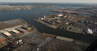
Port Newark–Elizabeth Marine Terminal, a major component of the Port of New York and New Jersey, is the principal container ship facility for goods entering and leaving the New York metropolitan area and the northeastern quadrant of North America.
The Chemical Coast is a section of Union and Middlesex counties in New Jersey located along the shores of the Arthur Kill, across from Staten Island, New York. The name is taken from the Conrail Chemical Coast Line, an important component in the ExpressRail system serving marine terminals in the Port of New York and New Jersey.

Port Ivory is a coastal area in the northwestern corner of Staten Island, New York City, New York, United States. It is located on Newark Bay near the entrances the Kill van Kull in the east and Arthur Kill in the west. It is bordered by Arlington to the east, Old Place to the south, Newark Bay to the north, and the Arthur Kill to the west.

New York New Jersey Rail, LLC is a switching and terminal railroad that operates the only car float operation across Upper New York Bay between Jersey City, New Jersey and Brooklyn, New York. Since mid-November 2008, it has been owned by the Port Authority of New York and New Jersey, which acquired it for about $16 million as a step in a process that might see a Cross-Harbor Rail Tunnel completed.

The Arthur Kill Vertical Lift Railroad Bridge is a rail vertical-lift bridge connecting Elizabethport, New Jersey, and the Howland Hook Marine Terminal on Staten Island, New York, United States. The bridge was built by the Baltimore and Ohio Railroad in 1959 to replace the Arthur Kill Bridge, a swing bridge opened in 1890. It contains a single track that is used mainly to carry garbage out of New York City, as well as to transport freight to destinations in western Staten Island. The bridge parallels the Goethals Bridge, which carries Interstate 278. It has the longest lift span of any vertical-lift bridge in the world, with two 215-foot (66 m) towers and a 558-foot (170 m) truss span that allows a 500-foot (152 m) channel. It clears mean high water by 31 feet (9.45 m) when closed and 135 feet (41 m) when lifted.

The Port of New York and New Jersey is the port district of the New York-Newark metropolitan area, encompassing the region within approximately a 25-mile (40 km) radius of the Statue of Liberty National Monument.
The Cross-Harbor Rail Tunnel is a proposed freight rail transport tunnel under Upper New York Bay in the Port of New York and New Jersey between northeastern New Jersey and Long Island, including southern and eastern New York City.
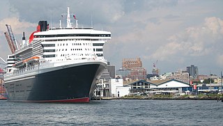
The Brooklyn Cruise Terminal is a cruise terminal in the Red Hook neighborhood of Brooklyn, New York City. The terminal is 180,000 square feet (17,000 m2) and sits on Buttermilk Channel, a tidal strait separating Brooklyn from Governors Island. It is owned by the City of New York and operated by Ports America. The terminal is one of three terminals for ocean-going cruise ships in the New York metropolitan area. Ships from Carnival Corporation call the terminal their home port.

Arlington Yard is a freight yard located on the North Shore Branch right of way of the Staten Island Railway in Staten Island, New York, United States. It lies west of the former Arlington station, east of Western Avenue, and north of the Staten Island Expressway in the Port Ivory neighborhood. The yard leads into the Travis Branch of the railway, the Howland Hook Container Terminal, and the Arthur Kill Lift Bridge to Elizabeth, New Jersey and the Chemical Coast and is part of the ExpressRail network.

Port Jersey, officially the Port Jersey Port Authority Marine Terminal and referred to as the Port Jersey Marine Terminal, is an intermodal freight transport facility that includes a container terminal located on the Upper New York Bay in the Port of New York and New Jersey. The municipal border of the Hudson County cities of Jersey City and Bayonne runs along the long pier extending into the bay.
Christopher Owen Ward is an American civil servant who served as executive director of the Port Authority of New York and New Jersey from May 1, 2008, until November 1, 2011, and as New York City Department of Environmental Protection commissioner from 2002 to 2005.

The Red Hook Marine Terminal is an intermodal freight transport facility in the Red Hook neighborhood of Brooklyn in New York City, on the Upper New York Bay in the Port of New York and New Jersey. The maritime facility handles container ships and bulk cargo and includes a container terminal. The Port Authority of New York and New Jersey (PANYNJ) bought the piers in the 1950s when there was still much break bulk cargo activity in the port. The container terminal was built in the 1980s. Nearly all labor on the terminal is supplied by Local 1814 of the International Longshoreman's Association union.
Greenville Yard is a freight rail yard in the Port of New York and New Jersey. It is located on Upper New York Bay in Jersey City, New Jersey, adjacent and north of Port Jersey. Originally developed in 1904 by the Pennsylvania Railroad, it was later taken over by Conrail. It has been owned by the Port Authority of New York and New Jersey since 2010. It takes its name from the former municipality of Greenville, now part of the city.

From the start of railroading in America through the first half of the 20th century, New York City and Long Island were major areas for rail freight transportation. However, their relative isolation from the mainland United States has always posed problems for rail traffic. Numerous factors over the late 20th century have caused further declines in freight rail traffic. Efforts to reverse this trend are ongoing, but have been met with limited success.

ExpressRail is a network of on- or near-dock rail yards supporting intermodal freight transport at the major container terminals of the Port of New York and New Jersey. The development of dockside trackage and rail yards for transloading has been overseen by the Port Authority of New York and New Jersey, which works in partnership with other public and private stakeholders. As of 2019, four ExpressRail facilities were in operation, with a total built capacity of 1.5 million lifts.

The South Brooklyn Marine Terminal (SBMT) is an intermodal shipping, warehousing, and manufacturing complex in the Port of New York and New Jersey. It is located along the Upper New York Bay, between 29th and 39th Streets in the Sunset Park and Greenwood Heights neighborhoods of Brooklyn, New York City. The site is adjacent to Bush Terminal and Industry City, which respectively lie directly to the south and east. A recycling and waste transfer facility managed by Sims Metal Management is a major tenant. In May 2018, the city contracted partners to activate the largely unused terminal. In 2024, major construction commenced of a 73-acre facility supporting the development of the Empire Wind 1 offshore wind farm.

The North Shore Branch is a partially abandoned branch of the Staten Island Railway in New York City, which operated along Staten Island's North Shore from Saint George to Port Ivory. The line continues into New Jersey via the Arthur Kill Vertical Lift Bridge to Aldene Junction in Cranford.

The Travis Branch is a branch of the Staten Island Railway in New York City, that operates from Arlington Yard to Fresh Kills, which is used for freight transportation along the West Shore, Staten Island.


