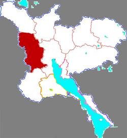
Jining former capital of Shandong. Is a prefecture-level city in southwestern Shandong province. It borders Heze to the southwest, Zaozhuang to the southeast, Tai'an to the northeast, and the provinces of Henan and Jiangsu to the northwest and south respectively. Jining, which is located directly to the north of Lake Nanyang, is today the northernmost city reachable by navigation on the Grand Canal of China making it an important inland port.

Xinghua is a county-level city under the administration of Taizhou, Jiangsu province, China. It is located in the central part of Jiangsu Province. It borders the prefecture-level cities of Yancheng to the north and east and Yangzhou to the west.

Lushan County is a county in Pingdingshan, in southwest-central Henan Province, China, with a population of 830,000. This county is known for housing the Spring Temple Buddha, a giant statue of Buddha.
Jia County or Jiaxian is a county under the administration of Pingdingshan City, in south-central Henan Province, China.

Xinfeng County is a county under the jurisdiction of the prefecture-level city of Ganzhou, in the far south of Jiangxi province, bordering Guangdong province to the west.

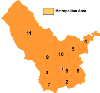
Yutai County is a county in the southwest of Shandong province, China. It is under the administration of Jining City and borders the Jiangsu counties of Feng and Pei to the south, Weishan County to the east, Rencheng District to the north, and Jinxiang County to the west.

Yuncheng is a county in the southwest of Shandong province, China. It is the northernmost county-level division of the prefecture-level city of Heze. It borders the Yellow River and Henan to the north, Liangshan County to the northeast, Jiaxiang County to the east, Juye County to the southeast, and Mudan District to the southwest, and Juancheng County to the west. It stretches 44 km (27 mi) from north to south and 36 km (22 mi) from east to west.

Wuzhong District is one of five urban districts of Suzhou, Jiangsu Province, China. It has a land area of 770 km2 (300 sq mi) and had a population of 590,000 in 2001.

Weishan County is a county of southwestern Shandong province, People's Republic of China, bordering Jiangsu province to the south. It is under the administration of Jining City, and much of its area is occupied by Nansi, or Weishan Lake.

Jinxiang County is a county of southwestern Shandong province, People's Republic of China, bordering Jiangsu province to the southeast. It is under the administration of Jining City.

Wenshang County is a county of southwestern Shandong province, People's Republic of China. It is under the administration of Jining City.

Sishui County is a county of southwestern Shandong province, People's Republic of China. It is the easternmost county-level division of Jining City. It takes its name from the Si River, which flows through the county.

Jinggangshan is a county-level city in the southwest of Jiangxi province, People's Republic of China, bordering Hunan province to the west. It is under the administration of the Ji'an City. It is located in the Luoxiao Mountains which cover some 670 km2 (260 sq mi).

Shengsi County is a county in the northeast of Zhejiang province consisting of an archipelago islands located to the east of Hangzhou Bay. It is under the administration of Zhoushan City and is the easternmost county-level division in the province. The islands of Greater and Lesser Yangshan are connected with Shanghai's Pudong New Area by the Donghai Bridge and their port forms part of the Port of Shanghai. They are, however, not counted among the islands of Shanghai.

County is a county in the east of Zhejiang province, China. It is under the administration of the city of Ningbo.
Tangyin County is a county in the north of Henan province, China. It is under the administration of Anyang City.

Wuyang County is a county in the central part of Henan province, China. It is both the westernmost and southernmost county-level division of the prefecture-level city of Luohe.
Linying County is a county of central Henan province, China. It is under the administration of Luohe city.
Jiahe County is a county in Hunan Province, China, it is under the administration of Chenzhou prefecture-level City.
Chahar Right Front Banner or Qahar Right Front Banner is a Banner of Inner Mongolia, China, surrounding Jining District and bordering Xinghe County to the east, Fengzhen City to the south, Zhuozi County to the west, and Chahar Right Back Banner to the north. Its territory includes Lake Huangqi. It is under the administration of Ulaan Chab City. Its most important settlement is Tugin Ul (Tuguiwula), where Tuguiwula railway station is located.
 Temple of Zengzi
 Wu family shrines
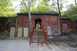 Qingshan Temple