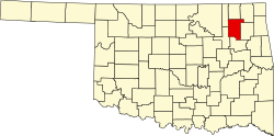
Justice, Oklahoma

Last updated

Justice, Oklahoma
Census Designated Place
Coordinates: 36°17′27″N95°33′49″W / 36.29083°N 95.56361°W / 36.29083; -95.56361
CountryUnited States
State Oklahoma
County Rogers
Elevation
[1]
646 ft (197 m)
Population
 (2000)
  Total1,311
GNIS feature ID2408457 [1]

Justice is a census-designated place (CDP) in Rogers County, Oklahoma, United States. The population was 1,311 at the 2000 census.

Contents

Geography

According to the United States Census Bureau, the CDP has a total area of 9.0 square miles (23 km2), all land.

Demographics

As of the census [2] of 2000, there were 1,311 people, 460 households, and 386 families residing in the CDP. The population density was 146.4 inhabitants per square mile (56.5/km2). There were 480 housing units at an average density of 53.6 per square mile (20.7/km2). The racial makeup of the CDP was 81.39% White, 0.38% African American, 12.05% Native American, 0.15% Asian, 0.08% from other races, and 5.95% from two or more races. Hispanic or Latino of any race were 0.69% of the population.

There were 460 households, out of which 37.0% had children under the age of 18 living with them, 75.7% were married couples living together, 6.5% had a female householder with no husband present, and 15.9% were non-families. 13.0% of all households were made up of individuals, and 5.2% had someone living alone who was 65 years of age or older. The average household size was 2.76 and the average family size was 3.00.

In the CDP, the population was spread out, with 25.7% under the age of 18, 5.9% from 18 to 24, 27.1% from 25 to 44, 29.3% from 45 to 64, and 12.1% who were 65 years of age or older. The median age was 40 years. For every 100 females there were 98.3 males. For every 100 females age 18 and over, there were 96.4 males.

The median income for a household in the CDP was $47,500, and the median income for a family was $51,618. Males had a median income of $41,429 versus $25,156 for females. The per capita income for the CDP was $20,909. About 6.2% of families and 8.8% of the population were below the poverty line, including 2.4% of those under age 18 and 5.4% of those age 65 or over.

Related Research Articles

<span class="mw-page-title-main">Avra Valley, Arizona</span> CDP in Pima County, Arizona

Avra Valley is a census-designated place (CDP) in Pima County, Arizona, United States. The population was 6,050 at the 2010 census, up from 5,038 in 2000.

<span class="mw-page-title-main">Holiday Heights, New Jersey</span> Populated place in Ocean County, New Jersey, US

Holiday Heights is an unincorporated community and census-designated place (CDP) located within Berkeley Township, in Ocean County, in the U.S. state of New Jersey. As of the 2010 United States Census, the CDP's population was 2,099.

<span class="mw-page-title-main">Cherry Tree, Oklahoma</span> Census-designated place in Oklahoma, USA

Cherry Tree is a census-designated place (CDP) in Adair County, Oklahoma, United States. The population was 883 at the 2010 census, a decline of 26.5 percent from the figure of 1,202 recorded in 2000.

<span class="mw-page-title-main">Christie, Oklahoma</span> CDP in Oklahoma, United States

Christie is a census-designated place (CDP) in Adair County, Oklahoma, United States. The population was 218 at the 2010 census, a 31.3 percent increase over the figure of 166 recorded in 2000.

<span class="mw-page-title-main">Briggs, Oklahoma</span> Census-designated place in Oklahoma, United States

Briggs is an unincorporated community and census-designated place (CDP) in Cherokee County, Oklahoma, United States. The population was 303 at the 2010 census.

<span class="mw-page-title-main">Welling, Oklahoma</span> Census-designated place in Oklahoma, United States

Welling is an unincorporated community and census-designated place (CDP) in Cherokee County, Oklahoma, United States. The population was 771 at the 2010 census, an increase of 15.25 percent over the figure of 669 recorded in 2000. It is home to The Salvation Army's Heart o' Hills camp and conference center.

Copeland is an unincorporated community and census-designated place (CDP) in Delaware County, Oklahoma, United States. The population was 1,629 at the 2010 census, a 12.5 percent increase from the figure of 1,448 recorded in 2000. Founded as a railroad community, it was named for local resident D.R. Copeland.

<span class="mw-page-title-main">Dennis, Oklahoma</span> Census-designated place in Oklahoma, United States

Dennis is an unincorporated community and census-designated place (CDP) in Delaware County, Oklahoma, near Grand Lake. The population was 195 at the 2010 census. The Dennis Post Office existed from March 25, 1914, until January 31, 1956. It is said to be named for a local resident, Peter Dennis.

Sams Corner is a census-designated place (CDP) in Mayes County, Oklahoma, United States. The population was 137 at the 2010 census, compared to 126 at the 2000 census.

Limestone is a census-designated place (CDP) in Rogers County, Oklahoma, United States, at an elevation of 705 feet. It is located less than 10 miles west of Claremore, Oklahoma on Oklahoma State Highway 20. The population was 753 as of July 2020.

<span class="mw-page-title-main">Sequoyah, Oklahoma</span> CDP in Oklahoma, United States

Sequoyah is a census-designated place (CDP) in Rogers County, Oklahoma, United States. The population was 671 at the 2000 census.

<span class="mw-page-title-main">Brushy, Oklahoma</span> CDP in Oklahoma, United States

Brushy is a census-designated place (CDP) in Sequoyah County, Oklahoma, United States, along U.S. Route 59 in the foothills of the Brushy Mountains. It is part of the Fort Smith, Arkansas-Oklahoma Metropolitan Statistical Area. The population was 900 at the 2010 census, an increase of 14.4 percent over the figure of 787 recorded in 2000.

Carlisle is a census-designated place (CDP) in Sequoyah County, Oklahoma, United States. It is part of the Fort Smith, Arkansas-Oklahoma Metropolitan Statistical Area. The population was 606 at the 2010 census.

Marble City Community is a census-designated place (CDP) in Sequoyah County, Oklahoma, United States. It is part of the Fort Smith, Arkansas-Oklahoma Metropolitan Statistical Area. The population was 420 at the 2000 census.

<span class="mw-page-title-main">McKey, Oklahoma</span> CDP in Oklahoma, United States

McKey is a census-designated place (CDP) in Sequoyah County, Oklahoma, United States. It is part of the Fort Smith, Arkansas-Oklahoma Metropolitan Statistical Area. The population was 135 at the 2000 census. McKey was established on the Old Osage and Arkansas Valley Railroad near MacKey's Salt Works. The post office existed from March 13, 1891, until July 14, 1928.

Short is a census-designated place (CDP) in Sequoyah County, Oklahoma, United States. It is part of the Fort Smith, Arkansas-Oklahoma Metropolitan Statistical Area. The population was 328 at the 2000 census.

Stony Point is a census-designated place (CDP) in Sequoyah County, Oklahoma, United States. It is part of the Fort Smith, Arkansas-Oklahoma Metropolitan Statistical Area. The population was 177 at the 2000 census.

<span class="mw-page-title-main">Chenoweth, Oregon</span> Unincorporated community in the state of Oregon, United States

Chenoweth is an unincorporated community in Wasco County, Oregon, United States. Locally the alternative spelling of Chenowith is used, such as for the 'Chenowith Elementary School'. For statistical purposes, the United States Census Bureau has defined Chenoweth as a census-designated place (CDP). The census definition of the area may not precisely correspond to local understanding of the area with the same name. The population of the CDP was 3,412 at the 2000 census.

<span class="mw-page-title-main">Potter Lake, Wisconsin</span> CDP in Wisconsin, United States

Potter Lake is a census-designated place (CDP) in the town of East Troy, Walworth County, Wisconsin, United States. The population was 1,117 at the 2020 census.

<span class="mw-page-title-main">Seymour, Illinois</span> Census-designated place in Illinois, United States

Seymour is a census-designated place in Champaign County, Illinois, United States. At the 2020 census it had a population of 317. It is part of Mahomet-Seymour Community Unit School District No. 3.

References

  1. 1 2 U.S. Geological Survey Geographic Names Information System: Justice, Oklahoma
  2. "U.S. Census website". United States Census Bureau . Retrieved January 31, 2008.