Talala, Oklahoma

Last updated

Talala
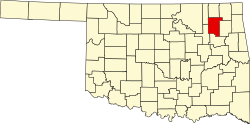
OKMap-doton-Talala.PNG
Location of Talala, Oklahoma
Coordinates: 36°31′46″N95°42′04″W / 36.52944°N 95.70111°W / 36.52944; -95.70111 [1]
Country United States
State Oklahoma
County Rogers
Area
[2]
  Total
0.45 sq mi (1.16 km2)
  Land0.45 sq mi (1.16 km2)
  Water0.00 sq mi (0.00 km2)
Elevation
[1]
682 ft (208 m)
Population
 (2020)
  Total
258
  Density575.89/sq mi (222.33/km2)
Time zone UTC−6 (Central (CST))
  Summer (DST) UTC−5 (CDT)
ZIP Code
74080
Area code(s) 539/918
FIPS code 40-72200 [3]
GNIS feature ID2413362 [1]

Talala is a town in Rogers County, Oklahoma, United States. The population was 273 at the 2010 census.

Contents

History

The Talala Post Office was established June 23, 1890. Talala was named for Captain John Talala of the 3rd Regiment, Indian Home Guard and a prominent Cherokee. It is mentioned in the Talala History Book that the word ta la la is associated with the tapping of a woodpecker's bill, which the woodpecker is a red-headed woodpecker that had these numerous birds there and even today. Talala is a Cherokee word for the Red-Headed Woodpecker. [4] An Indian made this discovery and so the town has taken this bird as part of its legacy, erecting signs on the North and South end of the town, and on its stationery at Town Hall and in the Museum.

Museum

On the property of the Museum, which was the original site of the Talala Post Office decades earlier, lies a statue made by the Talala artist Sandra VanZandt of two eagles with bricks surrounding it. In May 2012 three plaques honoring World War II veterans were displayed proudly nearby. Inside and within its walls lies most of the town's history.

Geography

Talala is 19 miles (31 km) northwest of Claremore, the county seat. [4]

According to the United States Census Bureau, the town has a total area of 0.3 square miles (0.78 km2), all land.

Demographics

Historical population
CensusPop.Note
1910 340
1920 107−68.5%
1930 19885.0%
1940 188−5.1%
1950 21011.7%
1960 147−30.0%
1970 16310.9%
1980 19117.2%
1990 2067.9%
2000 25021.4%
2010 2739.2%
2020 258−5.5%
U.S. Decennial Census [5]

As of the census [3] of 2010, there were 273 people and 81 families residing in the town. The population density was 910 inhabitants per square mile (350/km2). There were 128 housing units at an average density of 426.6 per square mile (164.7/km2). The racial makeup of the town was 71.4% White, 0.0% African American, 20.5% Native American, 0.0% Asian, and 8.1% from two or more races. Hispanic or Latino of any race were 0.7% of the population.

There were 109 households, out of which 33.0% had children under the age of 18 living with them, 51.4% were married couples living together, 14.7% had a female householder with no husband present, and 25.7% were non-families. Of all households 22.9% were made up of individuals, and 7.3% had someone living alone who was 65 years of age or older. The average household size was 2.50 and the average family size was 2.85.

In the town, the population was spread out, with 25.6% under the age of 18, 7.7% from 19 to 24, 29.4% from 25 to 44, 23.9% from 45 to 64, and 13.6% who were 65 years of age or older. The median age was 37.8 years. For every 100 females, there were 103.7 males. For every 100 females age 18 and over, there were 101.0 males.

The median income for a household in the town was $40,833, and the median income for a family was $58,250. Males had a median income of $40,833 versus $28,125 for females. The per capita income for the town was $17,810. About 5.9% of families and 8.2% of the population were below the poverty line, including 10.8% of those under the age of eighteen and none of those 65 or over.

Notable residents

Related Research Articles

<span class="mw-page-title-main">Cherokee County, Alabama</span> County in Alabama, United States

Cherokee County, Alabama is a county located in the northeastern part of the U.S. state of Alabama. As of the 2020 census, the population was 24,971. Its county seat is Centre. The county is named for the Cherokee tribe.

<span class="mw-page-title-main">Rogers County, Oklahoma</span> County in Oklahoma, United States

Rogers County is a county located in the northeastern part of the U.S. state of Oklahoma. As of the 2020 census, the population was 95,240, making it the sixth-most populous county in Oklahoma. The county seat is Claremore. Rogers County is included in the Tulsa, OK metropolitan statistical area.

<span class="mw-page-title-main">Greasy, Oklahoma</span> Census-designated place in Oklahoma, United States

Greasy is a census-designated place (CDP) in Adair County, Oklahoma, United States. The population was 372 at the 2010 census.

<span class="mw-page-title-main">Dry Creek, Oklahoma</span> Census-designated place in Oklahoma, United States

Dry Creek is an unincorporated community and census-designated place (CDP) in Cherokee County, Oklahoma, United States. The population was 227 at the 2010 census.

<span class="mw-page-title-main">Hulbert, Oklahoma</span> Town in Oklahoma, United States

Hulbert is a town in Cherokee County, Oklahoma, United States, named after Ben H. Hulbert, a prominent Cherokee man. The population was 483 at the 2020 census, previously it was 590 in 2010. Our Lady of the Annunciation of Clear Creek Monastery is a Benedictine monastery located in Hulbert. The Clear Creek Monastery, recently elevated to the status of an abbey, is a foundation abbey of France's Notre Dame de Fontgombault, which is itself a foundation abbey of Saint Pierre de Solesmes, also in France.

<span class="mw-page-title-main">Shady Grove, Cherokee County, Oklahoma</span> Census-designated place in Oklahoma, United States

Shady Grove is an unincorporated community and census-designated place (CDP) in Cherokee County, Oklahoma, United States. The population was 556 at the 2010 census. This is not to be confused with the similarly-named Shady Grove in McIntosh County, or the Shady Grove in Pawnee County.

<span class="mw-page-title-main">Welling, Oklahoma</span> Census-designated place in Oklahoma, United States

Welling is an unincorporated community and census-designated place (CDP) in Cherokee County, Oklahoma, United States. The population was 771 at the 2010 census, an increase of 15.25 percent over the figure of 669 recorded in 2000. It is home to The Salvation Army's Heart o' Hills camp and conference center.

Rocky Ford is a census-designated place (CDP) in Delaware and Cherokee counties, Oklahoma, United States. The population was 283 as of the 2020 Census, a whopping 464% increase over the population of 61 reported at the 2010 census.

<span class="mw-page-title-main">Kildare, Oklahoma</span> Town in Oklahoma, United States

Kildare is a town in Kay County, Oklahoma, United States. The population was 100 at the 2010 census, an 8.7 percent increase from the figure of 92 in 2000.

<span class="mw-page-title-main">Porum, Oklahoma</span> Town in Oklahoma, United States

Porum is a town in Muskogee County, Oklahoma, United States. It was named for John Porum Davis, a rancher, Civil War veteran, and Cherokee Nation councilman from the Canadian District in Indian Territory. The community was first known as Porum Gap, which united with another village named Starvilla in 1905. The product of this union became the present town of Porum. The population was 727 at the 2010 census, an increase of 0.3 percent from the figure of 725 recorded in 2000.

<span class="mw-page-title-main">Tribbey, Oklahoma</span> Town in Oklahoma, United States

Tribbey is a town in Pottawatomie County, Oklahoma, United States.The community was named for Alpheus M. Tribbey, landowner. The population was 337 by the 2020 United States census.

<span class="mw-page-title-main">Oologah, Oklahoma</span> Town in Oklahoma, United States

Oologah is a town in Rogers County, Oklahoma, United States. Renowned humorist Will Rogers was born on a ranch two miles east of Oologah, although he usually claimed Claremore as his birthplace "because nobody but an Indian can pronounce 'Oologah.'" There has been disagreement about the proper spelling for the town name. The official spelling is now Oologah. It was often spelled Oolagah before statehood, and this spelling appears on some old buildings.

<span class="mw-page-title-main">Gans, Oklahoma</span> Town in Oklahoma, United States

Gans is a town in Sequoyah County, Oklahoma, United States. It is part of the Fort Smith, Arkansas-Oklahoma Metropolitan Statistical Area. The population was 312 at the 2010 census, an increase of 50 percent over the figure of 208 recorded in 2000.

<span class="mw-page-title-main">Roland, Oklahoma</span> Town in Oklahoma, United States

Roland is a town in Sequoyah County, Oklahoma, United States. It is part of the Fort Smith, Arkansas-Oklahoma Metropolitan Statistical Area. The population was 3,169 at the 2010 census, compared to the figure of 2,842 recorded in 2000.

<span class="mw-page-title-main">Optima, Oklahoma</span> Town in Oklahoma, United States

Optima is a town in Texas County, Oklahoma, United States. As of the 2020 census, the town’s population was 338.

<span class="mw-page-title-main">Ochelata, Oklahoma</span> Town in Oklahoma, United States

Ochelata is a town in Washington County, Oklahoma, United States. The population was 424 at the 2010 census, a decline of 14.2 percent from the figure of 494 recorded in 2000.

<span class="mw-page-title-main">Parrish, Wisconsin</span> Town in Wisconsin, United States

Parrish is a town in Langlade County, Wisconsin, United States. The population was 91 at the 2010 census, down from 108 at the 2000 census. The unincorporated community of Parrish is located in the town.

<span class="mw-page-title-main">Wilson, Rusk County, Wisconsin</span> Town in Wisconsin, United States

Wilson is a town in Rusk County, Wisconsin, United States. The population was 84 at the 2000 census.

<span class="mw-page-title-main">Morris, Wisconsin</span> Town in Wisconsin, United States

Morris is a town in Shawano County, Wisconsin, United States. As of the 2020 Census, the town population was 417. The unincorporated community of Five Corners is located in the town.

<span class="mw-page-title-main">Sparrowhawk, Oklahoma</span> Census-designated place in Oklahoma, United States

Sparrowhawk is an unincorporated community and census-designated place (CDP) in Cherokee County, Oklahoma, United States. The population was 202 as of the 2020 Census, up from the population of 191 reported as of the 2010 census, at which time the CDP was known as Scraper. The older name of the community was given for Captain Archibald Scraper of the 2nd Regiment, Indian Home Guard. Sparrowhawk takes its name from Sparrow Hawk Mountain, which occupies most of the CDP.

References

  1. 1 2 3 U.S. Geological Survey Geographic Names Information System: Talala, Oklahoma
  2. "ArcGIS REST Services Directory". United States Census Bureau. Retrieved September 20, 2022.
  3. 1 2 "U.S. Census website". United States Census Bureau . Retrieved January 31, 2008.
  4. 1 2 Jon D. May, "Talala," Encyclopedia of Oklahoma History and Culture. Accessed April 27, 2015.
  5. "Census of Population and Housing". Census.gov. Retrieved June 4, 2015.

Further reading