
Kakrala is a city and municipal board in Badaun district in India state of Uttar Pradesh. It is located to the East of the district Headquarter. It is 12 km from Badaun. the term Kakrala originates from the apbhramsha Kakrabad. The most population of this town are consisting Muslims, as the Vibrant culture of India suggests, the town is also diverse in terms of religion, festivals etc. India has a unique culture of Unity in diversity, the same phenomenon has occurred in this town also. In the vista of towns of this state one distinguishes Kakrala as quite significant. In fact, Kakrala is the name of a city which has a well British era municipal board.It is situated approximately at 27.9 deg N 79.2 deg E. It has an average height of 160 meters or 524 feet. The discovery of Indian town or city becomes complete with the knowledge of its current demographic scenario. In order to meet the objectives, numerous demographers have organized surveys and research works and thus brought out significant information about Kakrala city. Regarding this, the Census report is praiseworthy. Data like population, literacy rate etc. can be deduced from this report. According to this report, Kakrala city has got a total population measurement of 40,380. Females are less in number than their male counterparts. This becomes obvious from the literacy rates of both males and females. In other words, male populace constitutes 53 %, while the total population of females comprises 57 %. Information about the children who are residing in Kakrala too can be deduced. Thus kids who are below six years of age constitute 20 % of the total population of Kakrala. Literacy rate adds to the information of this Kakrala city. The most of the population of the city belongs to the Muslim Rajputs. Kakrala has done a important great war with british government from 1914 to 1919.

Rurka Kalan is a village in the Tehsil Phillaur, Jalandhar, Punjab, India.

Khasala Kalan is a village of Rawalpindi District in the Punjab province of Pakistan. It is located at 33°26'24N 72°58'25E with an altitude of 370 meters (1217 ft) and lies south of the Rawalpindi on Adyala Road and approximately about 6 km meter ahead from adyala jail. A significant proportion of the population belong to the Araien And Rajput Families. In the Middle of Village A Tomb Of PIR QAZI ZAREEN BAIG SAHIB, A small DAM is Located Behind The Village Khasala Kalan, Very beautiful location and visiting and picnic spot.
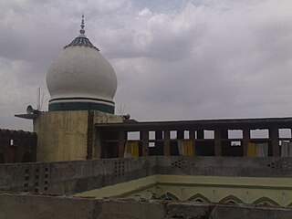
Ziarat Shareef is a mosque with a madrasah (Madrasah khāṣah in Kakrala city, Budaun district of Uttar Pradesh, India. The building was designed by Shah Saqlain Miyan. The building also contains the Khatoli Shareef of Shah Dargahi Miyan. People from across the country come to visit the Khatoli Shareef. This visit is called the ziyarat, hence the name of this building.
Kakrala Bhaika is a large village located in the Patiala district of the Indian state of Punjab.

Cheshmeh Kalan is a village in Itivand-e Jonubi Rural District, Kakavand District, Delfan County, Lorestan Province, Iran. At the 2006 census, its population was 20, in 5 families.
Kalan is a village in Alamut-e Pain Rural District, Rudbar-e Alamut District, Qazvin County, Qazvin Province, Iran. At the 2006 census, its population was 27, in 11 families.
Hans Kalan is a village near Jagraon, Punjab, India. It is 8.8 km from Chowkimann, which is near NH-95. It is 36.6 km from the main city Ludhiana and 11.1 km from Jagraon.

Mandor tehsil is a tehsil in Jodhpur District of Rajasthan state in western India.
Baba Kalan is a village in Bibi Hakimeh Rural District, in the Central District of Gachsaran County, Kohgiluyeh and Boyer-Ahmad Province, Iran. At the 2006 census, its population was 1,431, in 320 families.
Kalan is a village in Ojarud-e Sharqi Rural District, Muran District, Germi County, Ardabil Province, Iran. At the 2006 census, its population was 456, in 70 families.
Siah Kalan is a village in Ozomdel-e Shomali Rural District, in the Central District of Varzaqan County, East Azerbaijan Province, Iran. At the 2006 census, its population was 471, in 119 families.
Kalan is a village in Ozomdel-e Jonubi Rural District, in the Central District of Varzaqan County, East Azerbaijan Province, Iran. At the 2006 census, its population was 62, in 14 families.
Deh Kalan is a village in Lafur Rural District, Shirgah District, Savadkuh County, Mazandaran Province, Iran. At the 2006 census, its population was 210, in 74 families.
Kalan Kalayeh is a village in Machian Rural District, Kelachay District, Rudsar County, Gilan Province, Iran. At the 2006 census, its population was 532, in 144 families.
Dhab Kalan is a small village of Har Char Dhab Union council, Chakwal District in the Punjab Province of Pakistan.
Shekhupur Assembly constituency is one of the 403 constituencies of the Uttar Pradesh Legislative Assembly, India. It is a part of the Budaun district and one of the five assembly constituencies in the Aonla. First election in this assembly constituency was held in 2012 after the "Delimitation of Parliamentary and Assembly Constituencies Order, 2008" was passed and the constituency was formed in 2008. The constituency is assigned identification number 116.

Sowaddi Kalan or Swaddi Khas is a village in Ludhiana district in the Indian state of Punjab. It is one of the most educated villages in the area. Swaddi Kalan is a large village in Jagraon of Ludhiana district with a total of 954 families and 4,804 residents in 2011.
Dosanjh Kalan is a village in Phillaur tehsil of Jalandhar District of Punjab State, India. It is situated on Phagwara-Mukandpur road. The village is 10 kilometres (6.2 mi) from Phagwara, 19 kilometres (12 mi) from Banga, 32 kilometres (20 mi) from Jalandhar, and 123 kilometres (76 mi) from the state capital at Chandigarh. The village is administrated by a Sarpanch who is the elected representative of the village.
Ludhiana West Tehsil has 125 villages and is in the Ludhiana district, Punjab India.


