Related Research Articles
The South Pennar River is a river in India. Bangalore, Hosur, Krishnagiri,Kaveripattinam, and Cuddalore are the important cities on the banks of South Pennar river. This is the second longest river in Tamil Nadu, with a length of 497 km, after the Kaveri. Chandapura, Anekal, Hosur, Bagalur, and Chengam are the major industrial settlements on its banks. The river is severely polluted by industrial waste as it flows through major industrial areas in the eastern suburbs of Bangalore, Industrial parks of Hosur and Chengam.

Dharmapuri is a city in the north western part of Tamil Nadu, India. It serves as the administrative headquarters of Dharmapuri district which is the first district created in Tamil Nadu after the independence of India by splitting it from then Salem district on 2 October 1965. The city is located 50 km from Krishnagiri, 69 km from Salem, 90 km from Hosur, 117 km from Thiruvannamalai, 126 km from Bangalore and Erode, 181 km from Tiruppur, 200 km from Coimbatore and Tiruchirappalli, 300 km from Madurai and the state capital Chennai. It is located between latitudes N 11 47’ and 12 33’ and longitudes E 77 02’ and 78 40’. It is one of the major leading cultivators and producers of mangoes in the state along with Krishnagiri, and is often referred as Mango Capital of India.

Krishnagiri district is one of the 38 districts of the state of Tamil Nadu, in India. This district is carved out from Dharmapuri District by 2004. The municipal town of Krishnagiri is the district headquarters. In Tamil Nadu, e-Governance was first introduced at Krishnagiri district under the National e-Governance Project (NEGP) in revenue and social welfare departments on a pilot basis. The district is one of the largest producers of mangoes in India. As of 2011, the district had a population of 1,879,809 with a sex-ratio of 958 females for every 1,000 males. Hosur is the most populous town in the district.

Dharmapuri is one of the 38 districts in the state of Tamil-Nadu, India. It is the first district created in Tamil Nadu after the independence of India by splitting it from then-Salem district on 2 October 1965. Dharmapuri District is one of the major producers of mango in the state, fine quality granite is found in the district. It is also one of the main sericulture belts in the state. Around 30 percent of the district's area is under forest cover. Kaveri enters Tamil Nadu through this district. Dharmapuri district had the lowest literacy rate of 74.23% in Tamilnadu during the 2011 census.
Kambainallur is a panchayat town in karimangalam taluk of Dharmapuri district in the Indian state of Tamil Nadu. It also serves as a main source of transport, food, health and education for many villages situated around the Kambainallur.
Karimangalam is a town and taluk headquarters in Dharmapuri district in the Kongunadu region of Tamil Nadu. It is located at 20 km from Dharmapuri and 70 km from Salem.
Kaveripattinam is a town in Krishnagiri district in the northern part of Tamil Nadu.It is a revenue block in the Krishnagiri district of Tamil Nadu, India. It has a total of 36 panchayat villages.
Papparapatti is a panchayat town in Dharmapuri district in the Indian state of Tamil Nadu. The original name of this town was Pallur Pettai, later it was officially renamed as Papparapatti by the local government. The name Papparapatti was derived from Parpanar petai, which means the place where Brahmin community people lives.

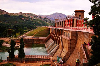
Krishnagiri is a city in the state of Tamil Nadu, India, and it serves as the administrative headquarters of Krishnagiri District formed in 2004. It is located at the bottom of Krishnadevaraya Hills, and the town is fully surrounded by hill rocks. It is located 250 km from Chennai, 45 km from Dharmapuri, and 90 km from Bengaluru. Krishnagiri is known as "Mango Capital of India" as mangoes are cultivated as the main crop, and the land here is extremely fertile with rich access to fresh water making it amenable to growing crops. Krishnagiri is the site of significant business and residential development. The Krishnagiri Dam was built in 1967.
The Government College of Engineering, Bargur is an engineering college in the Krishnagiri district of Tamil Nadu, India.
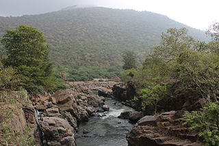
Hogenakkal Integrated Drinking Water Project is a fluorosis mitigation drinking water project being undertaken at Hogenakkal, Dharmapuri district, state of Tamil Nadu, India. It is scheduled to be executed by Tamil Nadu Water Supply and Drainage Board (TWAD), with funding from Japan Bank for International Cooperation (JBIC) using Tamil Nadu's share of Cauvery river water. The project aims to supply safe drinking water to drought prone & fluorosis affected Dharmapuri and Krishnagiri districts of Tamil Nadu.
Pochampalli taluk is one of the seven taluks of Krishnagiri district in the Indian state of Tamil Nadu. The majority of the population speak Tamil. The headquarters of the district is at Pochampalli.
Karimangalam taluk is a taluk in the Dharmapuri district of the Indian state of Tamil Nadu. On 10 February 2016, Karimangalam taluk was formed by merging parts of Palacode and Harur taluks of Dharmapuri district. The headquarters of the taluk is the town of Kariamangalam. This taluk contains a total of 52 panchayat villages.
The Cauvery North Wildlife Sanctuary is a protected area located in the Dharmapuri and Krishnagiri districts of Tamil Nadu, India. Sanctuary is named as it is located above the north of Cauvery river in Tamil Nadu state and south of river connects to the Cauvery Wildlife Sanctuary of Karnataka state. On 12 March 2014, the Government of Tamil Nadu declared Cauvery North Wild Life Sanctuary under clause (b) of sub-section (1) of Section 26-A of the Wild Life (Protection) Act, 1972 in Gazette No.II(2)/EF/254/2014.
The Arulmigu Muthu Mariamman Temple is located in Vedigoundan kottai in Krishnagiri district, Tamil Nadu, India. The festival of this temple is held at Tamil month of chitterai every year. Celebrate this famous festival at three days. It is located 25 km away from Dharmapuri and Krishnagiri, 15 km from Kaveripattinam and 5 km from Karimangalam.
Pochampalli is a small town in the Krishnagiri District of Tamil Nadu State, India. It also acts as the headquarters of Pochampalli taluk. Pochampalli is located 27 kilometers south from the district headquarters Krishnagiri, 30 kilometers from Dharmapuri, 30 kilometers from Tirupattur, and 256 kilometers from the state capital Chennai. It is located on SH-60.
Kovilur is a small Village in Nallampalli Block in Dharmapuri District of Tamil Nadu State, India. It comes under Nallampalli Panchayath. It is located 10 km towards South from District headquarters Dharmapuri. 4 km from Nallampalli.
Kethureddipatti is a Village Panchayat in Dharmapuri district of Tamil Nadu, India. It is located at 30 km (19 mi) from Dharmapuri town. It comes under Pappireddipatti taluk and Kadathur Block. It belongs to Pappireddipatti State Legislative Assembly Constituency and Dharmapuri Loksabha Constituency. It consists of nine panchayat wards. As per the 2011 Census, the total population of this village is 4,808.
References
- "Map of revenue blocks of Dharmapuri district". Government of Tamil Nadu. Archived from the original on 2016-03-03.
| Taluks |  | |
|---|---|---|
| Blocks | ||
| Town panchayats | ||
| Cities and towns |
| |
| Villages |
| |
| Revenue divisions | ||