
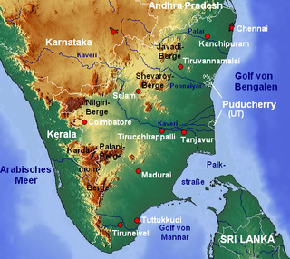
The Kaveri is one of the major Indian rivers flowing through the states of Karnataka and Tamil Nadu. The Kaveri River rises at Talakaveri in the Brahmagiri range in the Western Ghats, Kodagu district of the state of Karnataka, at an elevation of 1,341 m above mean sea level and flows for about 800 km before its outfall into the Bay of Bengal. It reaches the sea in Poompuhar, in Mayiladuthurai district. It is the third largest river – after Godavari and Krishna – in southern India, and the largest in the state of Tamil Nadu, which, on its course, bisects the state into north and south. In ancient Tamil literature, the river was also called Ponni.

Erode District is one of the 38 districts in the state of Tamil Nadu in India. It was the largest district by area in the state before the formation of Tirupur District in 2009. The headquarters of the district is Erode. It is divided into two revenue divisions, Erode and Gobichettipalayam, and is further subdivided into 10 taluks. Erode District was a part of Coimbatore District before its division into two on 17 September 1979. It covers an area of 5,722 square kilometres (2,209 sq mi), and as of 2011, had a population of 2,251,744.

Dharmapuri is a city in the north western part of Tamil Nadu, India. It serves as the administrative headquarters of Dharmapuri district which is the first district created in Tamil Nadu after the independence of India by splitting it from then Salem district on 2 October 1965. The city is located 50 km from Krishnagiri, 69 km from Salem, 60 km from Tirupattur, 90 km from Hosur, 117 km from Thiruvannamalai, 126 km from Bangalore and Erode, 181 km from Tiruppur, 200 km from Coimbatore and Tiruchirappalli, 300 km from Madurai and the state capital Chennai. It is located between latitudes N 11 47’ and 12 33’ and longitudes E 77 02’ and 78 40’. It is one of the major leading cultivators and producers of mangoes in the state along with Krishnagiri, and is often referred as Mango Capital of India.

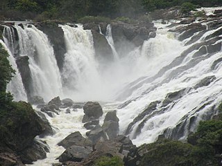
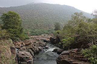
Hogenakkal Falls is a waterfall in South India on the Kaveri river on the border between Dharmapuri district of Tamil Nadu and Chamrajnagar district of Karnataka. It is located 46 km (29 mi) from Dharmapuri and 199 km (124 mi) from Chamrajnagar. Carbonatite rocks in this site are considered to be the oldest of its kind in South Asia and one of the oldest in the world. The Government of Tamil Nadu made a proposal to convert the falls into providing drinking water for the state.
Shivanasamudra Falls is a cluster of waterfalls on the borders of Malavalli, Mandya and Kollegala, Chamarajanagara, in Karnataka, India, situated along the river Kaveri. The falls form the contour between the districts of Chamarajanagara and Mandya. The Bharachukki Falls in Kollegala, with a height of 69 metres, and the Gaganachukki Falls in Malavalli, with a height of 90 metres, collectively form the Shivanasamudra Falls.

Tiruchirappalli District is one of the 38 districts, located along the Kaveri River, in Tamil Nadu, India. The headquarters of the district is the city of Tiruchirappalli.

Krishnagiri district is one of the 38 districts of the state of Tamil Nadu, in India. This district is carved out from Dharmapuri District by 2004. The municipal town of Krishnagiri is the district headquarters. In Tamil Nadu, e-Governance was first introduced at Krishnagiri district under the National e-Governance Project (NEGP) in revenue and social welfare departments on a pilot basis. The district is one of the largest producers of mangoes in India. As of 2011, the district had a population of 1,879,809 with a sex-ratio of 958 females for every 1,000 males. Hosur is the most populous town in the district.

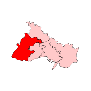
Dharmapuri is one of the 38 districts in the state of Tamil-Nadu, India. It is the first district created in Tamil Nadu after the independence of India by splitting it from then-Salem district on 2 October 1965. Dharmapuri District is one of the major producers of mango in the state, fine quality granite is found in the district. It is also one of the main sericulture belts in the state. Around 30 percent of the district's area is under forest cover. Kaveri enters Tamil Nadu through this district. Dharmapuri district had the lowest literacy rate of 74.23% in Tamilnadu during the 2011 census.
Pennagaram is a town in Dharmapuri district in the Indian state of Tamil Nadu. It is the headquarters of Pennagaram taluk (sub-district).
Hogenakkal Integrated Drinking Water Project is a fluorosis mitigation drinking water project being undertaken at Hogenakkal, Dharmapuri district, state of Tamil Nadu, India. It is scheduled to be executed by Tamil Nadu Water Supply and Drainage Board (TWAD), with funding from Japan Bank for International Cooperation (JBIC) using Tamil Nadu's share of Cauvery river water. The project aims to supply safe drinking water to drought prone & fluorosis affected Dharmapuri and Krishnagiri districts of Tamil Nadu.
The Hogenakkal Water Dispute is a conflict between the Indian states of Tamil Nadu and Karnataka over the implementation of Hogenakkal Integrated Drinking Water Project, whose foundation stone was laid in February 2008. The Rs. 13.34 billion project envisages water supply to 4040,000 people in the fluorosis affected Dharmapuri and Krishnagiri districts of Tamil Nadu.
Pennagaram is a state assembly constituency in Dharmapuri district in Tamil Nadu, India. Its State Assembly Constituency number is 58. It comprises Pennagaram taluk and a portion of Palacode taluk. It is a part of Dharmapuri constituency for national elections to the Parliament of India. It is one of the 234 State Legislative Assembly Constituencies in Tamil Nadu, in India.
Vazhapadi taluk is one of the thirteen taluks of Salem district in the Indian state of Tamil Nadu. The headquarters of the taluk is the town of Vazhapadi.
Pennagaram taluk is a taluk in the Dharmapuri district of the Indian state of Tamil Nadu. The headquarters of the taluk is the town of Pennagaram.

Dhinna Bellur is a village in Pennagarem Taluk, Dharmapuri District, Tamil Nadu, India. This village is surrounded by hills and 70% of the population is engaged in agriculture and allied activities for their livelihood. It is just 30 kilometres (19 mi) from Hogenakkal falls and close to a Muthaiyan Temple near Neruppur.
Hogenakkal are waterfalls located in Dharmapuri district of the state Tamil Nadu, India. Hogenakkal Eco Tourism seeks to protect wilderness and ecological integrity of Hogenakkal.
Palar is a river in the Indian states of Karnataka and Tamil Nadu. It originates near Guthiyalathur in Bhavani Taluk of Erode district in Tamil Nadu and forms border between Karnataka and Tamil Nadu. Later, it flows into the Kaveri River near Palar in Karnataka and Tamil Nadu.
Kalvarayan Hills taluk or Kalvarayanmalai taluk is one of the six taluks of Kallakurichi district in the Indian state of Tamil Nadu.
Tamil Nadu State Highway 60 (SH-60) connects Hogenakkal with Tirupattur.


