Dharmapuri, is a town in the western part of Tamil Nadu, India. The town is located at 50 km from Krishnagiri, 69 km from Salem, 126 km from Bangalore, 200 km from Coimbatore, and 300 km from the state capital Chennai. It is located between latitudes N 11 47’ and 12 33’ and longitudes E 77 02’ and 78 40’. It is one of top leading mango cultivator and producer of state.

Perundurai is a panchayat town in Erode district in the Indian state of Tamil Nadu. At present, Perundurai is the only special grade town panchayat among the 42 town panchayats in the district, sources said. It is located on National Highway 544 connecting Salem with Cochin. It is located 18 kilometres road distance from Erode Central Bus Terminus via Perundurai Road, and 36 kilometres from Tiruppur and 80 kilometres from Coimbatore and Salem respectively. Perundurai has developed as the industrial center with SIPCOT Industrial Estate and SEZ Complex. It is the Asia's Second largest SIPCOT.

Dharmapuri is one of the 38 districts in the state of Tamil Nadu in India. It is the first district created in Tamil Nadu after the independence of India by splitting it from then-Salem district on 2 October 1965. The other major towns in the district are Harur, Palacode, Karimangalam, Nallampalli, Pennagaram and Pappireddipatti. Dharmapuri District is one of the major producers of mango in the state, fine quality granite is found in the district. It is also one of the main sericulture belts in the state. Around 30 percent of the district's area is under forest cover. Kaveri enters Tamil Nadu through this district.
Chengam or Chengamma as on British records, is an important market town and a taluk headquarter in the Foot hills of Eastern ghats in Tiruvannamalai district of Tamil Nadu, India. Chengam is the gateway to the Chengam pass in the Eastern ghats between Javvadhu hills to the north and Chennakesava hills to the south. The town is also the center for various industrial activities which includes Sathanur dam hydro-electric project, Aavin milk processing plant and Periya Kolappadi SIDCO estate.
Harur is a third grade municipality in the Dharmapuri district of Tamil Nadu, India. It is one of two revenue blocks in the district.
Kambainallur is a panchayat town in karimangalam taluk of Dharmapuri district in the Indian state of Tamil Nadu. It also serves as a main source of transport, food, health and education for many villages situated around the Kambainallur.
Kilpennathur is a Panchayat Town in Tiruvanamalai district in the Indian state of Tamil Nadu. Kilpennathur is one of the taluks of Tiruvannamalai district and an assembly constituency of Tamil Nadu. The MLA of Kilpennathur assembly constituency is DMK party Mr. K. Pichandi. Vettavalam is the most populous town panchayat in this taluk. Kilpennathur is located a 12.25 degrees latitude and 79.224 degrees longitude. Nearest towns are Avalurpet, Vettavalam, Gingee and Tiruvannamalai, and Chennai is about 177 km away.
Manachanallur is a Town in Tiruchirappalli district in the Indian state of Tamil Nadu. Manachanallur is famous for an ancient temple, Sri Boominathar Temple of Lord Shiva.
Marandahalli is a panchayat town Dharmapuri district in the Indian state of Tamil Nadu. Located in the northern part of the district.
Natrampalli is a selection grade panchayat town and Taluk in Tirupattur district in the Indian state of Tamil Nadu. The Natrampalli block is a revenue block in the Tirupattur district of Tamil Nadu, India. It has a total of 26 panchayat villages. It is a small satellite town where many people go for work to places like Hosur, Vaniyambadi, Tirupattur Ambur and Pallikonda.
Palacode is a panchayat town in Dharmapuri district in the Indian state of Tamil Nadu.
Pallipattu is a town in Tiruvallur district in the state of Tamil Nadu, India.It is known for its rich and fertile agricultural lands and is blessed with the flowing of river, from west to east, named 'Kusasthalai'. It has produced personalities who have made a mark in film industry, medical profession, Information Technology, Entrepreneurship, Trading and politics. It is located 113 kilometres from Chennai, 40 kilometres from Chittoor, 51 kilometres from Tirupathi, 36 kilometres from Tiruttani, 50 kilometres from Arakkonam and border place of the state of Andhra Pradesh

Usilampatti is a town and a second grade municipality in the Indian state of Tamil Nadu. It is also a designated taluk and revenue division.
Vedasanthoor is a panchayat town in Dindigul district Located at Indian state of Tamil Nadu. Vedasanthoor town is 21 km from Dindigul city, 25 km from Oddanchatram town, and 82 km From Madurai.
Alangulam is a town in Tenkasi district, Tamil Nadu, India. It is a Special Grade Town Panchayat and the centre of the Alangulam Taluk in Tenkasi district.

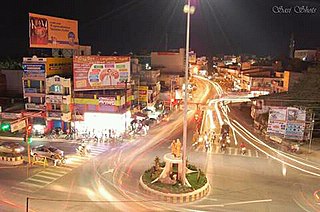
Krishnagiri is a Panchayat in the state of Tamil Nadu, India, and it serves as the administrative headquarters of Krishnagiri District formed in 2004. It is located at the bottom of Syed Basha Hills, and the city is fully surrounded by hill rocks. It is located 250 km from Chennai, 45 km from Dharmapuri, and 90 km from Bengaluru. Krishnagiri is known as "Mango Capital of India" as mangoes are cultivated as the main crop, and the land here is extremely fertile with rich access to fresh water making it amenable to growing crops. Krishnagiri is a rapidly growing city and is the site of significant business and residential development. The Krishnagiri Dam was built in 1967. Krishnagiri is currently undergoing expansion and a variety of small-scale industry zones are being set up. As of 2011, the city had a population of 199,657.

Thiruppuvanam is a town in Manamadurai Constituency and also Manamadurai division in the Indian state of Tamil Nadu. The town is famous for Sri Pushpavaneswarar temple, which is one of the Padal Petra Shiva sthalams.
Kadaladi in Tamil Nadu is 108 km from Madurai. Kadaladi is situated between Mudukulathur and Sayalgudi. It is a taluk headquarters and a revenue region of Ramanathapuram district.
Tirupattur taluk is a taluk in Tirupattur district of the Indian state of Tamil Nadu. The headquarters of the taluk is the town of Tirupattur. It is known as the "Sandalwood Town" due to the abundant availability of sandalwood trees in the surrounding hills. On August 15, 2019, honourable Chief Minister of Tamil Nadu, Edapaadi K. Palanisami announced Tirupattur as a new district of Tamil Nadu.
Pennagaram taluk is a taluk in the Dharmapuri district of the Indian state of Tamil Nadu. The headquarters of the taluk is the town of Pennagaram.


