
Dharmapuri is a city in the north western part of Tamil Nadu, India. It serves as the administrative headquarters of Dharmapuri district which is the first district created in Tamil Nadu after the independence of India by splitting it from then Salem district on 2 October 1965. The city is located 50 km from Krishnagiri, 69 km from Salem, 90 km from Hosur, 117 km from Thiruvannamalai, 126 km from Bangalore and Erode, 181 km from Tiruppur, 200 km from Coimbatore and Tiruchirappalli, 300 km from Madurai and the state capital Chennai. It is located between latitudes N 11 47’ and 12 33’ and longitudes E 77 02’ and 78 40’. It is one of the major leading cultivators and producers of mangoes in the state along with Krishnagiri, and is often referred as Mango Capital of India.

Krishnagiri district is one of the 38 districts of the state of Tamil Nadu, in India. This district is carved out from Dharmapuri District by 2004. The municipal town of Krishnagiri is the district headquarters. In Tamil Nadu, e-Governance was first introduced at Krishnagiri district under the National e-Governance Project (NEGP) in revenue and social welfare departments on a pilot basis. The district is one of the largest producers of mangoes in India. As of 2011, the district had a population of 1,879,809 with a sex-ratio of 958 females for every 1,000 males. Hosur is the most populous town in the district.

Dharmapuri is one of the 38 districts in the state of Tamil-Nadu, India. It is the first district created in Tamil Nadu after the independence of India by splitting it from then-Salem district on 2 October 1965. Dharmapuri District is one of the major producers of mango in the state, fine quality granite is found in the district. It is also one of the main sericulture belts in the state. Around 30 percent of the district's area is under forest cover. Kaveri enters Tamil Nadu through this district. Dharmapuri district had the lowest literacy rate of 74.23% in Tamilnadu during the 2011 census.
Kadathur is a panchayat town in Dharmapuri district in the Indian state of Tamil Nadu. Kadathur is situated 20 kilometres (12 mi) southeast of Dharmapuri. It is in the southern region of the district.
Pappireddipatti is a Town Panchayat of Dharmapuri district in the Indian state of Tamil Nadu and also a revenue Taluk of Dharmapuri district.

Krishnagiri is a city in the state of Tamil Nadu, India, and it serves as the administrative headquarters of Krishnagiri District formed in 2004. It is located at the bottom of Krishnadevaraya Hills, and the town is fully surrounded by hill rocks. It is located 250 km from Chennai, 45 km from Dharmapuri, and 90 km from Bengaluru. Krishnagiri is known as "Mango Capital of India" as mangoes are cultivated as the main crop, and the land here is extremely fertile with rich access to fresh water making it amenable to growing crops. Krishnagiri is the site of significant business and residential development. The Krishnagiri Dam was built in 1967.
Buddireddipatti is a village in Dharmapuri district, Tamil Nadu, India.
Bommidi is a panchayat town which is located in Pappireddipatti taluka of Dharmapuri district in Tamil Nadu, India. It is also known as B. Mallapuram. Bommidi's name is used for the railway station, the police station situated at Nadur, the post office, and bus transportation, while the name "B. Mallapuram" is used for schools, hospitals, and government officials.
Palacode taluk is a taluk in the Dharmapuri district of the Indian state of Tamil Nadu. The headquarters of the taluk is the town of Palacode. Part of Cauvery North Wildlife Sanctuary is located in this taluk.

Pappireddippatti is a state assembly constituency in Tamil Nadu, India, that was formed after constituency delimitation in 2007. Its State Assembly Constituency number is 60. Located in Dharmapuri district, it comprises portions of the Dharmapuri and Pappireddipatti taluks. It is included in the Dharmapuri parliamentary constituency for elections to the Parliament of India. It is one of the 234 State Legislative Assembly Constituencies in Tamil Nadu, in India.
Pappireddipatti block is a revenue block in the Dharmapuri district of Tamil Nadu, India. It has a total of 19 panchayat villages.
Gettupatti is a village in Dharmapuri District of Tamil Nadu State, India.
It comes under Dokkubothanahalli Panchayath and its south regions is covered by thoppur forest.
It is located 20 km towards South from Dharmapuri and 308 km from State capital Chennai.
Ammapalayam is a small village situated in Dharmapuri district, Tamil Nadu state in southern India. The village has one middle school.
Mallapuram and similar can mean these places in India:
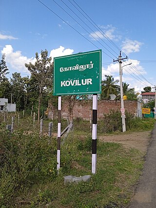
Kovilur is a small Village in Nallampalli Block in Dharmapuri District of Tamil Nadu State, India. It comes under Nallampalli Panchayath. It is located 10 km towards South from District headquarters Dharmapuri. 4 km from Nallampalli.
Kadagathur is a village panchayath under Dharmapuri Block and in Dharmapuri district in the state of Tamil Nadu, India. This village is located 6 km away from District Capital Dharamapuri.

Our Lady of Mt. Carmel Church is catholic parish church in B. Pallipatti village near Bommidi in Dharmapuri district in Tamil Nadu, India. This parish is famous for its Jesus life story open theater drama Maasattra Ratham performed every second Friday after Easter. Also this is one of the oldest parish in Dharamapuri Diocese.
Kethureddipatti is a Village Panchayat in Dharmapuri district of Tamil Nadu, India. It is located at 30 km (19 mi) from Dharmapuri town. It comes under Pappireddipatti taluk and Kadathur Block. It belongs to Pappireddipatti State Legislative Assembly Constituency and Dharmapuri Loksabha Constituency. It consists of nine panchayat wards. As per the 2011 Census, the total population of this village is 4,808.
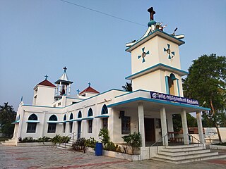
St. Antony's Church is a Roman Catholic church situated in Bommidi, Dharmapuri district, Tamil Nadu, India. This church holds great prominence among the Christians, leading to its elevation as a Shrine by the Dharmapuri Diocese.


