This article needs additional citations for verification .(February 2011) |
Keota | |
---|---|
Coordinates: 40°42′10″N104°04′31″W / 40.70278°N 104.07528°W | |
Country | USA |
State | Colorado |
County | Weld |
Established | 1880 |
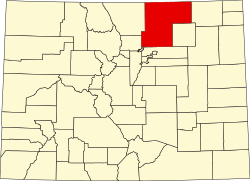
Keota is a mostly abandoned town located on the prairie in the Pawnee National Grasslands in Weld County in the U.S. state of Colorado.
Keota's elevation is 4,964 ft (1,513 m). [1] Keota is located approximately 50 miles east of Fort Collins on County Road 103. Pawnee Buttes, a pair of prominent sandstone escarpments, which are significant nesting areas for hawks, falcons, and eagles, is located nearby.
Keota was established as a homestead in 1880 by two sisters, Mary and Eva Beardsley, and sold to the Lincoln Land and Cattle Co. in 1888. Keota was a station stop on the "Old Prairie Dog Express" of the Burlington & Missouri River Railroad. The railroad was abandoned in 1970, and the track was removed by 1982. The railroad was mainly used for cattle shipping from Cheyenne to Sterling. [2] Keota lost its incorporated status in 1990. There were four different newspapers at four different times from 1908–1975. A post office operated briefly in 1890, was reopened in 1909, and closed in 1974. [3] The school was established in 1888 and closed sometime in 1951. The schoolhouse was torn down sometime in the 1950s, but the foundation still exists. The Dean Bivens family, who maintained the roads, moved out in September 1999.
The town of Line Camp in James A. Michener's novel Centennial ″was drawn from Keota.″ [4]
As of 2008, the town is home to several residents in modern houses surrounding the historic townsite. There are remains of the general store, several houses, and foundations on what was the north side of the town along with several foundations, including that of the previously-mentioned schoolhouse.
The Keota water tower still stands to this day; however, it is not in operation and would likely no longer be safe for storage of public drinking water. Water was once brought to Keota via rail cars due to its isolated location on Colorado's eastern plains.
The Republican River is a river in the central Great Plains of North America, rising in the High Plains of eastern Colorado and flowing east 453 miles (729 km) through the U.S. states of Nebraska and Kansas.
Pawnee National Grassland is a United States National Grassland located in northeastern Colorado on the Colorado Eastern Plains. The grassland is located in the South Platte River basin in remote northern and extreme northeastern Weld County between Greeley and Sterling. It comprises two parcels totaling 193,060 acres (78,130 ha) largely between State Highway 14 and the Wyoming border. The larger eastern parcel lies adjacent to the borders of both Nebraska and Wyoming. It is administered in conjunction with the Arapaho-Roosevelt National Forest from the U.S. Forest Service office in Fort Collins, with a local ranger district office in Greeley.
Thistle is a ghost town in Spanish Fork Canyon in southeastern Utah County, Utah, United States. During the era of steam locomotives, the town's primary industry was servicing trains for the Denver and Rio Grande Western Railroad. The fortunes of the town were closely linked with those of the railroad until the changeover to diesel locomotives, when the town started to decline.
Carr is an unincorporated community that used to have a U.S. Post Office in Weld County, Colorado, United States. The ZIP Code of Carr is 80612. Some consider Carr a ghost town. Today, a few old houses remain plus a church and the schoolhouse, but the old store fronts are gone. There are some scattered old foundations throughout the town. There are a growing number of year-round residents, so the town no longer appears abandoned.
Peyton is an unincorporated town, a post office, and a census-designated place (CDP) located in and governed by El Paso County, Colorado, United States. The CDP is a part of the Colorado Springs, CO Metropolitan Statistical Area. The Peyton post office has the ZIP Code 80831. At the United States Census 2020, the population of the Peyton CDP was 214.
Nixon Township is one of thirteen townships in DeWitt County, Illinois, US. As of the 2020 census, its population was 492 and it contained 231 housing units.
Mill Fork is a ghost town located approximately 12 miles (19 km) east of Thistle in Spanish Fork Canyon in Utah County, Utah, United States. Named for its sawmills, Mill Fork was important in the development of the railroad through the canyon. The arched entrance to the small, well-tended Mill Fork Cemetery is a landmark on U.S. Route 6 between the cities of Spanish Fork and Price.
Waconda is an historic unincorporated community in Marion County, Oregon, United States, near the crossroads of River Road and Waconda Road. Waconda was once a station on the Oregon Electric Railway and formerly had a post office by the same name.
Dome is a ghost town located in Yuma County, in southwestern Arizona, United States. It is located in the Dome Valley south of the Gila River. Originally Swiveler's Station, 20 miles (32 km) east of Fort Yuma on the Butterfield Overland Mail route, a post office was established here in 1858. It was first under the name of Gila City, the nearby boomtown one and a half miles (2.4 km) west of Swiveler's, but the post office closed July 14, 1863, after most of the town was swept away in the Great Flood of 1862, and then abandoned for the La Paz gold rush along the Colorado River. After the railroad passed by the site and an attempt at large scale mining of the placers began, a new post office was established as Dome in 1892 but soon closed when the attempt failed. Subsequently it opened and closed several times before finally closing in 1940.
Malvern is an unincorporated community located in the town of Pelican, Oneida County, Wisconsin, United States. Malvern is 6.5 miles (10.5 km) east-southeast of Rhinelander.
Lochiel is a populated place and former border crossing in southern Santa Cruz County, Arizona, United States, approximately 25 miles east of Nogales. Basically a ghost town, the townsite is located in the southwestern part of the San Rafael Valley on Washington Gulch, about 1.5 miles west of the Santa Cruz River. It was first settled in the late-1870s and mostly abandoned by 1986. The town served the ranches of the San Rafael Valley and the Washington Camp and Duquesne mining towns of the Patagonia Mountains, approximately five miles to the northwest up Washington Gulch.
Cuervo is an unincorporated community in Guadalupe County, New Mexico, United States. Cuervo is located along Interstate 40 16.8 miles (27.0 km) east-northeast of Santa Rosa. Cuervo had a post office until September 10, 2011; it still has its own ZIP code, 88417. The community is nearly a ghost town now, having been split by the construction of I-40; but there is still a small church and a gas station.
Spokane is a ghost town located in Custer County, South Dakota, United States. It was a mining camp in the Black Hills.
Adelaide is an extinct town located in Fremont County, Colorado, United States. The townsite is located at 38.5600°N 105.0908°W at an elevation of 6,949 feet (2,118 m). Previously known as Robinson, the former mining camp and railroad water is located along the Phantom Canyon Road. The Adelaide Bridge is located just north of the townsite.
Duette is an unincorporated community in Manatee County, Florida, United States. State Road 62 intersects with Keentown Road in Duette. The area is home to Bunker Hill Vineyard and Winery. The only remaining single-classroom schoolhouse in Florida, Duette School, is on the National Register of Historic Places.
Apex was a lumber town on the Grand Canyon Railway situated in Coconino County, Arizona. Founded as company town on a wye on the Atlantic and Pacific Railroad, the community was dissolved when lumbering activity ceased in 1936.
Hills Prairie, or Hill's Prairie, is an unincorporated community in Bastrop County, Texas, United States. According to the Handbook of Texas, the community had a population of 50 in 2000. It is located within the Greater Austin metropolitan area.
Saint Vrains is a ghost town in Weld County, Colorado, United States.
Sligo is a ghost town in Weld County, in the U.S. state of Colorado.
Dick is an extinct town in Weld County, in the U.S. state of Colorado.