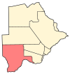
Hukuntsi is a village in Kgalagadi District (Kalahari) in Botswana.
Shoshong is a town in Botswana, formerly the chief settlement of the eastern Bamangwato.
Gakhibane (Gachibana) is a village in Kgalagadi District of Botswana. It is located close to the border with South Africa. Gachibana has a primary school, and the population was 746 in 2011 census. Ghakhibane is known for its road through the Molopo fossil river valley. It is located at the upper right side of the river.
Khuis is a village in Kgalagadi District of Botswana. It is located close to the border with South Africa. Khuis has a primary school, and the population was 897 in 2011 census.
Middlepits is a village in Kgalagadi District of Botswana. It borders South Africa and has an immigration border post.
Kolonkwaneng is a village in Kgalagadi District of Botswana. It is located close to the border with South Africa and it has a primary school. The population was 599 in 2011 census.
Bogogobo is a village in Kgalagadi District of Botswana. It is located close to the border with South Africa and has a primary school. The population was 360 in 2011 census.
Maralaleng is a village in Kgalagadi District of Botswana. It is located east of the district capital Tshabong and has a primary school. The climate in Maraleng is considered to be a desert climate. The population is 586 according to a 2011 census.
Tshane is a village in Kgalagadi District of Botswana. It is situated in Kalahari Desert, and is served by local Tshane Airport. The village has a primary school and the population was 1020 in 2011 census. It has a !Xóõ cultural centre. The lowest temperature registered in Tshane was −8.0 °C (17.6 °F). The record high temperature registered in Tshane was 41.0 °C (105.8 °F).
Lehututu is a village in Kgalagadi District of Botswana. It is in the Kalahari Desert, and it has primary and secondary schools. The population was 1,956 in 2011 census.
Lokgwabe is a village in Kgalagadi District of Botswana. It is located in the Kalahari Desert and the village has a primary school. The population was 1,417 in 2011 census.
Monong is a village in Kgalagadi District of Botswana. It is located in Kalahari Desert, and it has a primary school. The population was 267 in 2011 census.
Ncaang is a village in Kgalagadi District of Botswana. It is located in the northern part of the district, in Kalahari Desert. The population was 228 in 2011 census.
Zutswa is a village in Kgalagadi District of Botswana. It is located in the Kalahari Desert and it has a primary school. The population was 469 in 2011 census.
Ngwatle is a village in Kgalagadi District of Botswana. It is located in the Kalahari Desert, in the north-west part of the district. The population was 271 in 2011 census.
Make is a village in Kgalagadi District of Botswana. It is located in the Kalahari Desert and it has a primary school. The population was 398 in 2011 census.
Inalegolo is a village in Kgalagadi District of Botswana. It is located in the north-east part of the district, in Kalahari Desert, and it has a primary school. The population was 533 in 2011 census. The chief of the village is Kgosi Seka Boraetsile.
Phuduhudu is a village in Kgalagadi District of Botswana. It is located in the northeast part of the district, in the Kalahari Desert, and it has a primary school. The population was 482 in the 2011 census.
Dikwididi is a village in Kgatleng District of Botswana. It is located around 40 km east of Gaborone. The village has a primary school and the population was 225 in 2011 census.
Dikgonnye is a village in Kgatleng District of Botswana. The village is located 40 km north-west of Mochudi, and it has a primary school. The population was 431 in 2011 census.

