Pangani District Council is one of eleven administrative districts of Tanga Region in Tanzania. The District covers an area of 1,756 km2 (678 sq mi). It is bordered to the north by Muheza District, to the east by Zanzibar Channel, to the south by the Chalinze District of Pwani Region, and to the west by the Handeni District. The district is comparable in size to the land area of Guadeloupe. The district seat (capital) and largest settlement in Pangani district is the town of Pangani. The district is named after the historic Pangani River. As of the 2022 census, the population was Pangani district was 75,642, making it the least populous district in Tanga Region.

Tanga Region is one of Tanzania's 31 administrative regions. The region covers an area of 26,667 km2 (10,296 sq mi). The region is comparable in size to the combined land area of the nation state of Burundi. The regional capital is the municipality of Tanga city. Located in northeast Tanzania, the region is bordered by Kenya and Kilimanjaro Region to the north; Manyara Region to the west; and Morogoro and Pwani Regions to the south. It has a coastline to the east with the Indian Ocean. According to the 2022 national census, the region had a population of 2,615,597.

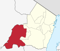
Handeni District is one of the 11 districts of Tanga Region in Tanzania. The District covers an area of 6,534 km2 (2,523 sq mi). It is bordered to the west by the Kilindi District and the Handeni Urban District, to the north by the Korogwe District, to the east by the Pangani District, and to the south by the Pwani Region. In 2002 Kilindi District was formed out of the district. The administrative capital of the district is Mkata town. According to the 2002 Tanzania National Census, the population of the Handeni District was 248,633. According to the 2022 census, the population had increased to: 384,353.
Lushoto is one of the eleven districts of Tanga Region in Tanzania. It is bordered to the northeast by Kenya, to the east by the Muheza District, to the northwest by the Kilimanjaro Region, west by Korogwe District and to the south by the Bumbuli District. The district's capital and largest town is Lushoto.

Elerai is an administrative ward in Arusha District, Arusha Region of Tanzania. It is one of 19 urban administrative wards in the municipality. The ward is bordered by Olasiti ward to the west, Kiranyi ward to the north, Ngarenaro ward to the east, Sombetini to the south and, a tiny portion of Unga L.T.D ward to the southeast. The ward covers an area of 3.746 km2 and ranks number eleven in the area in Arusha city. The ward is home to the national National College of Tourism, the African Court and Tanzania National Parks Authority (TANAPA)'s national headquarters, also the Arusha Modern school. The school's famous alumna is Tanzanian recording artist, Vanessa Mdee, who received secondary education there. According to the 2012 census, the ward had a total population of 40,749.

Korogwe District also known as Korogwe District Council is one of the eleven districts of Tanga Region in Tanzania. The District covers an area of 6,534 km2 (2,523 sq mi). It is bordered to the northeast by the Lushoto District and north by Bumbuli District. Korogwe District also bordered to the east by the Mkinga District and the Muheza District, to the South by the Handeni Rural District and the Korogwe Urban District, and to the West by the Kilimanjaro Region. The highest point in Korogwe District is Mafi Peak at 1,442m.
Handeni Town Council also known as Handeni Urban District is one of the 11 districts of the Tanga Region of Tanzania. The district covers an area of 837.4 km2 (323.3 sq mi). The administrative capital of the district is Mdoe. Handeni Town District is bordered to the east by Handeni District and the west by Kilindi District.

Korogwe Urban District is one of the eleven districts of the Tanga Region of Tanzania. The District covers an area of 225.3 km2 (87.0 sq mi). Korogwe Urban District is bordered to the north by Korogwe Rural District and to the south by Handeni Rural District. The administrative capital of the district is Korogwe town. According to the 2012 Tanzania National Census, the population of Korogwe Urban District was 68,308.
Chanika is an administrative ward in Handeni Town Council of Tanga Region in Tanzania. The ward covers an area of 4.1 km2 (1.6 sq mi), and has an average elevation of 671 m (2,201 ft). According to the 2012 census, the ward has a total population of 10,994.
Mdoe is an administrative ward in Handeni Town Council of Tanga Region in Tanzania. The ward covers an area of 4.6 km2 (1.8 sq mi), and has an average elevation of 808 m (2,651 ft). According to the 2012 census, the ward has a total population of 9,541. Mode is also the seat of Handeni Town government as all the district council's administration offices are located there.

Mlimani is an administrative ward in Handeni Town Council of the Tanga Region in Tanzania. It covers an area of 49.6 km2 (19.2 sq mi), and has an average elevation of 766 m (2,513 ft). As of the 2012 census, the population is 5,252.
Msasa is an administrative ward in Handeni Town Council of Tanga Region in Tanzania. The ward covers an area of 26.5 km2 (10.2 sq mi), and has an average elevation of 753 m (2,470 ft). According to the 2012 census, the ward has a total population of 4,328.
Vibaoni is an administrative ward in Handeni Town Council of Tanga Region in Tanzania. The ward covers an area of 16.2 km2 (6.3 sq mi), and has an average elevation of 802 m (2,631 ft). According to the 2012 census, the ward has a total population of 6,078.
Kwediyamba is an administrative ward in Handeni Town Council of Tanga Region in Tanzania. The ward covers an area of 30.4 km2 (11.7 sq mi), and has an average elevation of 665 m (2,182 ft). According to the 2012 census, the ward has a total population of 4,152.
Songe is an administrative ward in Kilindi District of Tanga Region in Tanzania. The ward covers an area of 90 km2 (35 sq mi), and has an average elevation of 1,272 m (4,173 ft). According to the 2012 census, the ward has a total population of 14,801.
Kilindi is an administrative ward in Kilindi District of Tanga Region in Tanzania. The ward covers an area of 374.8 km2 (144.7 sq mi), and has an average elevation of 770 m (2,530 ft). According to the 2012 census, the ward has a total population of 11,093.
Kilwa is an administrative ward in Kilindi District of Tanga Region in Tanzania. The ward covers an area of 153 km2 (59 sq mi), and has an average elevation of 858 m (2,815 ft). According to the 2012 census, the ward has a total population of 6,835.
Kimbe is an administrative ward in Kilindi District of Tanga Region in Tanzania. The ward covers an area of 464 km2 (179 sq mi), and has an average elevation of 626 m (2,054 ft). According to the 2012 census, the ward has a total population of 14,249.

Jaila is an administrative ward in Kilindi District of Tanga Region in Tanzania. The ward covers an area of 157 km2 (61 sq mi), and has an average elevation of 733 m (2,405 ft). According to the 2012 census, the ward has a total population of 12,319.

Chalinze District Council is one of nine administrative districts of Pwani Region in Tanzania. The district covers an area of 8,042 km2 (3,105 sq mi). The district is comparable in size to the land area of Puerto Rico. Chalinze District is bordered to the northeast by Pangani District, the north by Handeni District and in Kilindi District of Tanga Region. The district is bordered to the east by the Indian Ocean. Chalinze is also borders Bagamoyo District, Kibaha Urban District and to the South by Kibaha District. On the western part, the district is bordered by Mvomero District and Morogoro Rural District of Morogoro Region.