Kingsmead, Bath

Last updated

Kingsmead
New King Street, Bath (geograph 3307150).jpg
New King Street, in the east of the ward
Somerset UK location map.svg
Red pog.svg
Kingsmead
Location within Somerset
Population5,516 (ward, 2011) [1]
OS grid reference ST740653
Unitary authority
Ceremonial county
Region
Country England
Sovereign state United Kingdom
Post town BATH
Postcode district BA1
Dialling code 01225
Police Avon and Somerset
Fire Avon
Ambulance South Western
UK Parliament
List of places
UK
England
Somerset
51°22′59″N2°22′05″W / 51.383°N 2.368°W / 51.383; -2.368
Kingsmead Square after which the ward is named, at the eastern end of the ward Kings-Mead Square - geograph.org.uk - 1715987.jpg
Kingsmead Square after which the ward is named, at the eastern end of the ward

Kingsmead is an electoral ward within Bath, England, which encompasses most of Bath city centre and stretches west along the A4 to meet Newbridge and Weston wards. The ward elects two councillors to the Bath and North East Somerset unitary authority. [2]

Contents

Kingsmead is rarely used as the name of an area of Bath, and is primarily used for electoral purposes. [3] The ward stretches about 1 mile (1.6 km) westward from Bath city centre, straddling the A4 road north of the River Avon. The ward is separated by the large Royal Victoria Park into a city centre eastern end, and a western residential end known as Lower Weston. [4]

A boundary review in 2018, which came into force at the May 2019 local elections, abolished Abbey ward and extended Kingsmead eastwards as far as the Avon to include most of the city centre. At the same time the ward's western extent was slightly reduced, in order to move the Chelsea Road shopping street wholly into Newbridge ward. [2] [5]

Residents in the western end of the ward often use the facilities, such as schools, of the neighbouring Newbridge and Weston wards, and associate themselves with these localities. [4]

The closed Mangotsfield and Bath Branch Line formerly ran from Green Park station, now a shopping area, in the ward. The Bristol & Bath Railway Path runs through the ward, but on the River Avon path rather than the former railway track which has been developed upon just south of the ward.

The electoral wards surrounding the ward are: Newbridge to the west, Weston and Lansdown to the north, Walcot and Bathwick to the east, and Widcombe & Lyncombe, Oldfield Park and Westmoreland to the south over the River Avon. [4]

Notable places

Notable places within the ward, from east to west, include:

Related Research Articles

<span class="mw-page-title-main">Bath, Somerset</span> City in Somerset, England

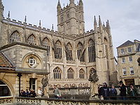
Bath is a city and unparished area in the Bath and North East Somerset unitary area in the ceremonial county of Somerset, England, known for and named after its Roman-built baths. At the 2021 Census, the population was 101,557. Bath is in the valley of the River Avon, 97 miles (156 km) west of London and 11 miles (18 km) southeast of Bristol. The city became a World Heritage Site in 1987, and was later added to the transnational World Heritage Site known as the "Great Spa Towns of Europe" in 2021. Bath is also the largest city and settlement in Somerset.

<span class="mw-page-title-main">Somerset</span> County in South West England

Somerset is a ceremonial county in South West England which borders Gloucestershire and Bristol to the north, Wiltshire to the east, Dorset to the south-east and Devon to the south-west. It is bounded to the north and west by the Severn Estuary and the Bristol Channel, its coastline facing southeastern Wales. Its traditional border with Gloucestershire is the River Avon.

<span class="mw-page-title-main">Avon (county)</span> Former non-metropolitan and ceremonial county in England

Avon was a non-metropolitan and ceremonial county in the west of England that existed between 1974 and 1996. The county was named after the River Avon, which flows through the area. It was formed from the county boroughs of Bristol and Bath, together with parts of the administrative counties of Gloucestershire and Somerset.

<span class="mw-page-title-main">Bath and North East Somerset</span> Non-metropolitan district in England

Bath and North East Somerset (B&NES) is a unitary authority district in England. Bath and North East Somerset Council was created on 1 April 1996 following the abolition of the county of Avon. It is part of the ceremonial county of Somerset.

<span class="mw-page-title-main">North East Somerset (UK Parliament constituency)</span> Parliamentary constituency in the United Kingdom

North East Somerset is a constituency represented in the House of Commons of the UK Parliament, since it was created for the 2010 general election, by Jacob Rees-Mogg of the Conservative Party.

<span class="mw-page-title-main">Weston, Bath</span> Electoral ward in Bath, United Kingdom

Weston is a suburb and electoral ward of Bath in Bath and North East Somerset, South West England, located in the northwest of the city. Originally a separate village, Weston has become part of Bath as the city has grown, first through the development of Lower Weston in Victorian times and then by the incorporation of the village into the city, with the siting of much local authority housing there in the period after World War II.

<span class="mw-page-title-main">High Littleton</span> Village in Somerset, England

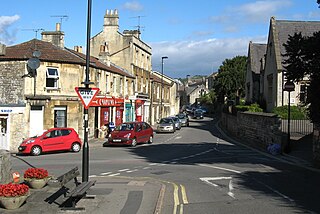
High Littleton is a village and civil parish in Somerset, England, about 1.2 miles (1.9 km) north of Paulton and 7.5 miles (12 km) south-west of Bath. The parish includes the small village of Hallatrow and the hamlets of White Cross, Greyfield and Mearns; the northeastern part of High Littleton village is known as Rotcombe.

<span class="mw-page-title-main">Newbridge, Bath</span> Electoral ward in Bath, United Kingdom

Newbridge is a largely residential electoral ward on the western edge of Bath, England.

<span class="mw-page-title-main">Walcot, Bath</span> Area within the City of Bath, England

Walcot is a suburb of the city of Bath, England. It lies to the north-north-east of the city centre, and is an electoral ward of the city.

Abbey was an electoral ward covering the centre of Bath, England. It was abolished as part of the boundary changes effected at the elections held on 2 May 2019.

Westmoreland is an area and electoral ward in the south-west of Bath, England. Although still shown on some Ordnance Survey mapping, Westmoreland is rarely used by residents as the name of an area of Bath, and is primarily used for electoral purposes within the Bath and North East Somerset unitary authority, electing two councillors.

<span class="mw-page-title-main">1999 Bath and North East Somerset Council election</span>

Elections were held on 6 May 1999 to elect 65 local councillors for Bath and North East Somerset Council, the second election for the council. The results are show below. After the election, a minority Liberal Democrat administration was formed.

<span class="mw-page-title-main">2003 Bath and North East Somerset Council election</span>

Elections were held on 1 May 2003 to elect 65 local councillors for Bath and North East Somerset Council. The results are shown below. Following the election, a coalition was formed between the Liberal Democrats and Conservative councillors. Cllr Paul Crossley became leader of the council.

<span class="mw-page-title-main">2011 Bath and North East Somerset Council election</span>

The Bath and North East Somerset Council election was held on 5 May 2011 to elect 65 local councillors for Bath and North East Somerset Council. Following the election, a minority Liberal Democrat administration was formed. Cllr Paul Crossley became leader of the council.

<span class="mw-page-title-main">Timeline of Bath, Somerset</span> History

The following is a timeline of the history of the city of Bath, Somerset, England.

<span class="mw-page-title-main">2015 Bath and North East Somerset Council election</span>

The 2015 Bath and North East Somerset Council election took place on 7 May 2015 to elect members of Bath and North East Somerset Council in England. This coincided with other local elections and the 2015 general election.

<span class="mw-page-title-main">2019 Bath and North East Somerset Council election</span> 2019 local election in Bath and North East Somerset

The 2019 Bath and North East Somerset Council election was held on 2 May 2019 to elect members of Bath and North East Somerset Council in England.

References

  1. "Ward population 2011" . Retrieved 7 April 2015.
  2. 1 2 "Bath & North East Somerset". Local Government Boundary Commission for England . Retrieved 26 April 2019.
  3. "The Avon (Structural Change) Order 1995". legislation.gov.uk. The National Archives. Retrieved 19 March 2011.
  4. 1 2 3 "Final recommendations published for new ward boundaries across B&NES". Bath Echo. 7 August 2018. Retrieved 26 April 2019.
  5. "Bath & North East Somerset Council Elections, Thursday 2 May 2019". Bath & North East Somerset Council. March 2019. Retrieved 10 April 2019.