Lyncombe is a district and electoral ward in Bath, Somerset, and a former parish in the Diocese of Bath and Wells. In the mid-19th century the parish was formed when the parish of Widcombe and Lyncombe was split in two, but it was abolished in the late 1960s. The village of Lyncombe existed since at least the Saxon period prior to becoming part of the City of Bath.
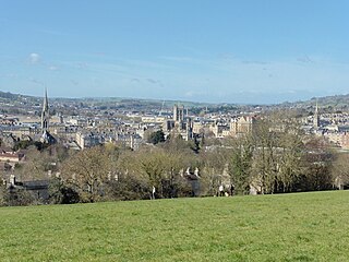
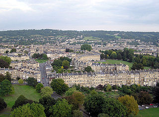
Lyncombe takes its name from the Celtic word cwm meaning valley, with the Lyn being the name of the stream that runs through it.[2] The present day district is approximately centred on the Western part of this valley, known as Lyncombe Vale, and extends down to the more urban area around the River Avon across from Bath Spa railway station. The northern area of the electoral ward is known as Bear Flat.[3]
The Manor of Lyncombe was ecclesiastical property from the time of Osric, king of the Hwicce in the 7th century to the Norman Conquest.[5] A charter of the City of Bath records that in 970 King Edgar "granted ten hides at Cliftune (i.e. Lyncombe), near Bath, Somerset, to St Peter's church, Bath, in return for 100 mancuses of gold and ten hides at Cumtune (possibly Chilcompton or Compton Dando, Somerset)."[6]
When Bath became popular as a spa town during the Georgian era, Lyncombe Vale was a famous beauty spot often visited by the well-to-do, and Jane Austen visited on one of her stays in the city.[11] A mineral spring was discovered in Lyncombe Vale in 1737 by Mr Charles Milsom, a cooper (after whose son, Milsom Street in Bath was named[12]). When attempting to fix a leaking fishpond he noticed a sulphurous odour, and saw water bubbling up from the ground. He then styled himself as a doctor and invited friends and neighbours to drink it.[12][13] The following year a Dr Hillary wrote a treatise on the health-giving properties of the water, and the two men built a stone edifice over the spring to receive patients.[14][15] However this weakened the ground and caused the spring to fail.[16]
Advertisement for King James's Palace
Lyncombe House, adjacent to the spa, was often called "King James's palace", a name derived from a tradition that James II of England stayed there with his consort Mary of Modena after abdicating the throne.[18] Although this cannot be corroborated, it is known that Mary made a long visit to Bath in 1687, and later the king joined her at a time when the city would not have afforded them the privacy they sought in the face of great public discontent. Lyncombe, less than a mile from the city, would have been a likely refuge.[19] The house remained a popular destination until the 19th century. A 1792 advertisement in the local newspaper proclaims of "A Publick Night, [at] King James's Palace, Illuminations, and far more Brilliant Fireworks that ever were exhibited in the Gardens".[20]
During the Industrial Revolution the district of Lyncombe and Widcombe was noted for the manufacture of woollen cloth, with 565 males over the age of 20 being employed in the industry in 1831.[21] The area closest to the river was considered the manufacturing part of Bath, whereas the valley of Lyncombe Vale to the south remained a more secluded area of natural beauty.[22]
In 1835 the Municipal Corporations Act extended the boundary of the city of Bath to include the entire parish of Lyncombe and Widcombe.[23] Twenty years later in 1855, and following an increase in the population of the area, Widcombe and Lyncombe were split into two parishes, with the church of St Mark's to become the parish church of Lyncombe, and St Matthews the parish church of Widcombe:
Your Majesty's Commissioners for building new churches beg leave humbly to represent that, when the last census was taken, the parish of Lyncombe and Widcombe, in the county of Somerset, and diocese of Bath and Wells, contained a population of nine thousand nine hundred and seventy-three persons... having taken into consideration all the circumstances of the said parish... it appears to them to be expedient that the same should be divided into two distinct and separate parishes for all ecclesiastical purposes whatever... and that the same should be respectively named "The parish of Lyncombe" and "The parish of Widcombe".
The boundaries of the parish of Lyncombe commence at the north-western corner of such parish, where the same adjoins the parish of Twerton and the River Avon, and then proceed eastwardly along the middle of the said River Avon to Lower Widcombe Mill, on the west; then leaving the said River Avon and proceeding southwardly along the middle of the street or road, called Lyncombe Hill, and south-westwardly along the middle of the road or lane, called Greenway-lane, and then again, southwardly, along the middle of the road or lane, called Entry Hill, to the corner of the road near the house called the Cross Keys Inn, where the said parish of Lyncombe adjoins the parish of South Stoke; then proceeding in a westwardly direction along the boundary separating the said parish. of Lyncombe from the parish of South Stoke to the point where the same adjoins the parish of Englishcombe; then proceeding northwardly along the boundaries separating the said parish of Lyncombe from the parishes of Englishcombe and Twerton to the point where the boundary line of the said parish of Lyncombe commenced.
In 1972 due to a declined population and attendances the parish of Lyncombe was abolished and incorporated into a new parish of Saint Bartholomew based in nearby Oldfield Park:
PASTORAL MEASURE 1968 Notice is hereby given that Her Majesty was pleased on the 23rd October 1972, by Order in Council to confirm a Scheme made by the Church Commissioners for (1) altering the boundaries of the parishes of Bath, Lyncombe and Bath, Widcombe, in the diocese of Bath and Wells, (2) declaring redundant the parish church of the parish of Bath, Lyncombe, and (3) altering the name of the benefice and parish of Bath, Lyncombe to "The benefice (or parish) of Bath, Saint Bartholomew".
Bath is a city in the ceremonial county of Somerset, in England, known for and named after its Roman-built baths. At the 2021 Census, the population was 94,092. Bath is in the valley of the River Avon, 97 miles (156 km) west of London and 11 miles (18 km) southeast of Bristol. The city became a UNESCO World Heritage Site in 1987, and was later added to the transnational World Heritage Site known as the "Great Spa Towns of Europe" in 2021. Bath is also the largest city and settlement in Somerset.
Bath and North East Somerset (B&NES) is a unitary authority district in Somerset, South West England. Bath and North East Somerset Council was created on 1 April 1996 following the abolition of the county of Avon. It is part of the ceremonial county of Somerset.
Bath is a constituency in the House of Commons of the Parliament of the United Kingdom represented by Wera Hobhouse of the Liberal Democrats.
Twerton is a suburb of the city of Bath, in the Bath and North East Somerset district, in the ceremonial county of Somerset, England, situated to the west of the city, and home to the city's football club, Bath City.
Newton St Loe is a small Somerset village and civil parish located close to the villages of Corston and Stanton Prior, between Bath and Bristol in England. The majority of the village is owned by the Duchy of Cornwall. The parish has a population of 681.
Weston is a suburb and electoral ward of Bath in Bath and North East Somerset, Somerset, England, located in the northwest of the city. Originally a separate village, Weston has become part of Bath as the city has grown, first through the development of Lower Weston in Victorian times and then by the incorporation of the village into the city, with the siting of much local authority housing there in the period after World War II.
Englishcombe is a village and civil parish in Bath and North East Somerset just south-west of Bath, England. The parish, which also includes the hamlets of Inglesbatch and Nailwell, had a population of 318 at the 2011 census.
George Phillips Manners was a British architect, who was Bath City Architect from 1823 to 1862.
Bear Flat is a neighbourhood within the city of Bath, Somerset, England, to the south of the city centre and to the west of Beechen Cliff. It forms the southern part of the Widcombe and Lyncombe electoral ward. The Wellsway road (A367) to Shepton Mallet, runs through Bear Flat, forming part of the ancient British Roman Fosse Way. This was originally the main pilgrimage route from Bath and its abbey, to the nearby ecclesiastical centres of Wells and Glastonbury.
Swainswick is a small village and civil parish, 3 miles (4.8 km) northeast of Bath, on the A46 in the Bath and North East Somerset unitary authority, Somerset, England. The parish has a population of 265. The village name was also spelled Sweyneswik and Sweyneswick in the early 13th to 14th Century.
St Thomas à Becket Church is a parish church of Widcombe in Bath, Somerset southwest England, and is one of a number of churches named after Thomas Becket. It is a Grade II* listed building.
Widcombe is a district of Bath, England, immediately south-east of the city centre, across the River Avon.
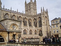
The buildings and architecture of Bath, a city in Somerset in the south west of England, reveal significant examples of the architecture of England, from the Roman Baths, to the present day. The city became a World Heritage Site in 1987, largely because of its architectural history and the way in which the city landscape draws together public and private buildings and spaces. The many examples of Palladian architecture are purposefully integrated with the urban spaces to provide "picturesque aestheticism". In 2021, the city was added to a second World Heritage Site, a group of historic spa towns across Europe known as the "Great Spas of Europe". Bath is the only entire city in Britain to achieve World Heritage status, and is a popular tourist destination.
Kingsmead is an electoral ward within Bath, England, which encompasses most of Bath city centre and stretches west along the A4 to meet Newbridge and Weston wards. The ward elects two councillors to the Bath and North East Somerset unitary authority.
Westmoreland is an area and electoral ward in the south-west of Bath, England. Although still shown on some Ordnance Survey mapping, Westmoreland is rarely used by residents as the name of an area of Bath, and is primarily used for electoral purposes within the Bath and North East Somerset unitary authority, electing two councillors.
The following is a timeline of the history of the city of Bath, Somerset, England.
The 2019 Bath and North East Somerset Council election was held on 2 May 2019 to elect members of Bath and North East Somerset Council in England.
↑ Aylmer, Janet (2003). In the Footsteps of Jane Austen; Through Bath to Lyncombe and Widcombe: A Walk Through History. Copperfield Books. ISBN978-0-9528210-6-9.
1 2 Robert Edward Myhill Peach. Street Lore of Bath. p.131.
↑ Maurice Scott (1984). Discovering Widcombe and Lyncombe. Widcombe Association. pp.30–31. ISBN0-9520876-0-X. A Dr Hilary 'analysed' the water and 'proved' its health-giving properties and wrote a treatise on it. Confident that he had discovered an aqueous treasure, he and Mr Milsom built a large edifice in 1738 for the reception of patients who were expected at the spa. The work of erecting the building disturbed the ground to such an extent the springs disappeared; the scheme therefore had to be abandoned and the cost to speculators was £1500
This page is based on this Wikipedia article Text is available under the CC BY-SA 4.0 license; additional terms may apply. Images, videos and audio are available under their respective licenses.