Kismet, Kansas | |
---|---|
Coordinates: 37°12′16″N100°42′06″W / 37.20444°N 100.70167°W [1] | |
Country | United States |
State | Kansas |
County | Seward |
Founded | 1880s |
Incorporated | 1929 |
Area | |
• Total | 0.24 sq mi (0.61 km2) |
• Land | 0.24 sq mi (0.61 km2) |
• Water | 0.00 sq mi (0.00 km2) |
Elevation | 2,779 ft (847 m) |
Population | |
• Total | 340 |
• Density | 1,400/sq mi (560/km2) |
Time zone | UTC-6 (CST) |
• Summer (DST) | UTC-5 (CDT) |
ZIP code | 67859 |
Area code | 620 |
FIPS code | 20-37325 |
GNIS ID | 2395552 [1] |
Kismet is a city in Seward County, Kansas, United States. [1] As of the 2020 census, the population of the city was 340. [3] It is located along U.S. Route 54 highway.
The first post office in Kismet was established in November 1888. [4]
According to the United States Census Bureau, the city has a total area of 0.24 square miles (0.62 km2), all of it land. [5]
Census | Pop. | Note | %± |
---|---|---|---|
1940 | 227 | — | |
1950 | 180 | −20.7% | |
1960 | 150 | −16.7% | |
1970 | 294 | 96.0% | |
1980 | 368 | 25.2% | |
1990 | 421 | 14.4% | |
2000 | 484 | 15.0% | |
2010 | 459 | −5.2% | |
2020 | 340 | −25.9% | |
U.S. Decennial Census |
The 2020 United States census counted 340 people, 124 households, and 101 families in Kismet. [6] [7] The population density was 1,440.7 per square mile (556.2/km2). There were 154 housing units at an average density of 652.5 per square mile (251.9/km2). [7] [8] The racial makeup was 69.12% (235) white or European American (59.71% non-Hispanic white), 0.88% (3) black or African-American, 2.94% (10) Native American or Alaska Native, 1.76% (6) Asian, 0.0% (0) Pacific Islander or Native Hawaiian, 14.12% (48) from other races, and 11.18% (38) from two or more races. [9] Hispanic or Latino of any race was 32.94% (112) of the population. [10]
Of the 124 households, 40.3% had children under the age of 18; 58.9% were married couples living together; 18.5% had a female householder with no spouse or partner present. 16.9% of households consisted of individuals and 8.9% had someone living alone who was 65 years of age or older. [7] The average household size was 2.7 and the average family size was 2.9. [11] The percent of those with a bachelor’s degree or higher was estimated to be 21.8% of the population. [12]
26.2% of the population was under the age of 18, 8.8% from 18 to 24, 24.7% from 25 to 44, 23.5% from 45 to 64, and 16.8% who were 65 years of age or older. The median age was 37.5 years. For every 100 females, there were 102.4 males. [7] For every 100 females ages 18 and older, there were 110.9 males. [7]
The 2016-2020 5-year American Community Survey estimates show that the median household income was $58,542 (with a margin of error of +/- $8,709) and the median family income was $60,625 (+/- $13,870). [13] Males had a median income of $40,000 (+/- $7,799) versus $15,625 (+/- $14,835) for females. The median income for those above 16 years old was $32,386 (+/- $10,772). [14] Approximately, 7.6% of families and 10.5% of the population were below the poverty line, including 22.8% of those under the age of 18 and 7.8% of those ages 65 or over. [15] [16]
As of the census [17] of 2010, there were 459 people, 145 households, and 115 families residing in the city. The population density was 1,912.5 inhabitants per square mile (738.4/km2). There were 155 housing units at an average density of 645.8 per square mile (249.3/km2). The racial makeup of the city was 86.1% White, 0.7% African American, 1.5% Native American, 0.4% Asian, 9.4% from other races, and 2.0% from two or more races. Hispanic or Latino of any race were 35.5% of the population.
There were 145 households, of which 48.3% had children under the age of 18 living with them, 67.6% were married couples living together, 9.0% had a female householder with no husband present, 2.8% had a male householder with no wife present, and 20.7% were non-families. 19.3% of all households were made up of individuals, and 9% had someone living alone who was 65 years of age or older. The average household size was 3.17 and the average family size was 3.64.
The median age in the city was 29.1 years. 37.9% of residents were under the age of 18; 7.2% were between the ages of 18 and 24; 26.6% were from 25 to 44; 18.2% were from 45 to 64; and 10.2% were 65 years of age or older. The gender makeup of the city was 52.5% male and 47.5% female.
As of the census [18] of 2000, there were 484 people, 159 households, and 123 families residing in the city. The population density was 2,097.0 inhabitants per square mile (809.7/km2). There were 172 housing units at an average density of 745.2 per square mile (287.7/km2). The racial makeup of the city was 71.90% White, 1.24% African American, 0.62% Native American, 21.07% from other races, and 5.17% from two or more races. Hispanic or Latino of any race were 32.23% of the population.
There were 159 households, out of which 54.7% had children under the age of 18 living with them, 66.0% were married couples living together, 7.5% had a female householder with no husband present, and 22.6% were non-families. 19.5% of all households were made up of individuals, and 7.5% had someone living alone who was 65 years of age or older. The average household size was 3.04 and the average family size was 3.51.
In the city, the population was spread out, with 37.8% under the age of 18, 7.9% from 18 to 24, 29.5% from 25 to 44, 17.1% from 45 to 64, and 7.6% who were 65 years of age or older. The median age was 28 years. For every 100 females, there were 106.8 males. For every 100 females age 18 and over, there were 102.0 males.
The median income for a household in the city was $39,531, and the median income for a family was $38,750. Males had a median income of $25,729 versus $29,583 for females. The per capita income for the city was $15,600. About 10.5% of families and 11.2% of the population were below the poverty line, including 12.8% of those under age 18 and none of those age 65 or over.
The community is served by Southwestern Heights USD 483 public school district. Its high school, Southwestern Heights, is located between Kismet and Plains along U.S. Route 54 highway. The Southwestern Heights High School mascot is Southwestern Heights Mustangs. [19]
Kismet High School was closed through school unification. The Kismet High School mascot was Kismet Pirates. [20]
Colony is a city in Anderson County, Kansas, United States. As of the 2020 census, the population of the city was 381.
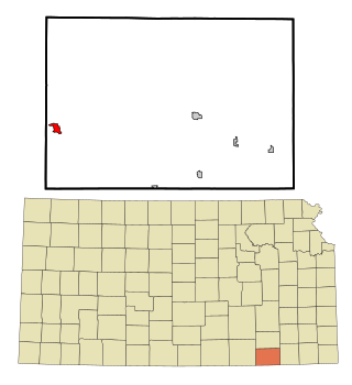
Cedar Vale is a city in Chautauqua County, Kansas, United States. As of the 2020 census, the population of the city was 476.
Green is a city in Clay County, Kansas, United States. As of the 2020 census, the population of the city was 95.
Glasco is a city in Cloud County, Kansas, United States. As of the 2020 census, the population of the city was 441.
Waverly is a city in Coffey County, Kansas, United States. As of the 2020 census, the population of the city was 574.
Hepler is a city in Crawford County, Kansas, United States. As of the 2020 census, the population of the city was 90.
Ford is a city in Ford County, Kansas, United States. As of the 2020 census, the population of the city was 203.
Gove City, more commonly known as Gove, is a city in and the county seat of Gove County, Kansas, United States. As of the 2020 census, the population of the city was 80.
Circleville is a city in Jackson County, Kansas, United States. As of the 2020 census, the population of the city was 153.
Delia is a city in Jackson County, Kansas, United States. As of the 2020 census, the population of the city was 151.
Edgerton is a city in Johnson County, Kansas, United States, and part of the Kansas City metropolitan area. As of the 2020 census, the population of the city was 1,748. It is home to a large BNSF intermodal train facility named Logistics Park Kansas City.
Dighton is a city in and the county seat of Lane County, Kansas, United States. As of the 2020 census, the population of the city was 960. Dighton is named for Dick Dighton, a surveyor.
Hartford is a city in Lyon County, Kansas, United States. As of the 2020 census, the population of the city was 355.
Dearing is a city in Montgomery County, Kansas, United States. As of the 2020 census, the population of the city was 382.
Elk City is a city in Montgomery County, Kansas, United States, along the Elk River. As of the 2020 census, the population of the city was 260.
Corning is a city in Nemaha County, Kansas, United States. As of the 2020 census, the population of the city was 212.
Lenora is a city in Norton County, Kansas, United States. As of the 2020 census, the population of the city was 207.
Belleville is a city in and the county seat of Republic County, Kansas, United States. As of the 2020 census, the population of the city was 2,007.
Bel Aire is a city in Sedgwick County, Kansas, United States, and a suburb of Wichita. As of the 2020 census, the population of the city was 8,262.
Colwich is a city in Sedgwick County, Kansas, United States, located northwest of Wichita. As of the 2020 census, the population of the city was 1,455.