Krautergersheim

Last updated
Krautergersheim
Krüterrische
Krautergersheim 022.JPG
A house in Krautergersheim
Blason Krautergersheim 67.svg
Location of Krautergersheim
Krautergersheim
France location map-Regions and departements-2016.svg
Red pog.svg
Krautergersheim
Grand Est region location map.svg
Red pog.svg
Krautergersheim
Coordinates: 48°28′34″N7°34′03″E / 48.4761°N 7.5675°E / 48.4761; 7.5675 Coordinates: 48°28′34″N7°34′03″E / 48.4761°N 7.5675°E / 48.4761; 7.5675
Country France
Region Grand Est
Department Bas-Rhin
Arrondissement Sélestat-Erstein
Canton Obernai
Intercommunality Pays de Sainte-Odile
Government
  Mayor (20202026) René Hoelt [1]
Area
1
6.37 km2 (2.46 sq mi)
Population
 (Jan. 2019) [2]
1,715
  Density270/km2 (700/sq mi)
Time zone UTC+01:00 (CET)
  Summer (DST) UTC+02:00 (CEST)
INSEE/Postal code
67248 /67880
Elevation149–159 m (489–522 ft)
1 French Land Register data, which excludes lakes, ponds, glaciers > 1 km2 (0.386 sq mi or 247 acres) and river estuaries.

Krautergersheim is a commune in the Bas-Rhin department in Alsace in north-eastern France. [3] It lies between Strasbourg and Obernai.

Contents

Geography

Krautergersheim is located in the district of Sélestat-Erstein and the township of Obernai. The village is located close to the A 35 connecting Barr and Strasbourg. There are two main areas:

The commune occupies an area of 6.4 km2 (2.5 sq mi). The nearest villages are Meistratzheim, Innenhei, Hindhead and Illkirch-Graffenstaden, the largest, 12 km (7.5 mi) to the south-west.

The river Ehn (formerly Ergers) flows through the area.

Toponymy

The commune, known as Ergersheimas, is mentioned as existing in 736 in a document of the Abbey of Murbach Eringisashaim, written in 778. The Abbess of Sainte-Odile, Herrad of Landsberg, mentions the commune in his writings.

According to humanist Wimpheling, Kraut, the German word for cabbage, was added to the name in the sixteenth century to distinguish it from a similar-named resort near Molsheim.

History

Roman remains and Merovingian tombs attest to the site being occupied during Roman times. Germans settled the area in the sixth and seventh centuries. Various abbeys mention the village: Murbach Abbey in 735, Hohenbourg Abbey (Mont Sainte-Odile) in 778 and Baumgarten Abbey in 1050.

The commune was destroyed in 1587 during the War of Religion; it was burned by passing mercenaries. During the Thirty Years' War the troops of General Ernst von Mansfeld pillaged and sacked the churches and abbeys, abused the peasants and burned the village. In 1632 Swedish King Gustav II Adolf came to the aid of German Protestants, and occupied Alsace.

In 1634, two years after the death of their king, the Swedes left Alsace. From the fourteenth century, many noble families ruled the commune. The Berckheim family had a castle that was later purchased by Bernard Frederick Turckheim and his wife Lili Schoenemann. At the fall of the Empire, Austrian units occupied Krautergersheim for three years.

Commune activities include potato farming, the industrial production of sauerkraut, and building a strong artisan and commercial industry.

Sauerkraut

The sign reads "Capital of the Sauerkraut". Krautergersheim 003.JPG
The sign reads "Capital of the Sauerkraut".

Krautergersheim is known as the Choucroute (sauerkraut) capital of the region. A Choucroute Festival is celebrated on the last Sunday of each September.

There is a linguistic connection with the name Krautergersheim, since "Kraut" means cabbage in the local language and cabbage is the main ingredient in Sauerkraut/Choucroute.

Population

The inhabitants are called Chouvilloises and Chouvillois, which refers to the area's connection with cabbage.

Historical population
YearPop.±% p.a.
1968 1,086    
1975 1,043−0.58%
1982 1,303+3.23%
1990 1,388+0.79%
1999 1,590+1.52%
2007 1,611+0.16%
2012 1,723+1.35%
2017 1,680−0.50%
Source: INSEE [4]

See also

Related Research Articles

<span class="mw-page-title-main">Alsace</span> Region of France

Alsace is a cultural region and a territorial collectivity in eastern France, on the west bank of the upper Rhine next to Germany and Switzerland. In 2020, it had a population of 1,898,533. Alsatian culture is characterized by a blend of Germanic and French influences.

<span class="mw-page-title-main">Bas-Rhin</span> Department of France

Bas-Rhin is a department in Alsace which is a part of the Grand Est super-region of France. The name means 'Lower Rhine', referring to its lower altitude among the two French Rhine departments: it is downstream of the Haut-Rhin department. Note that both belong to the European Upper Rhine region. It is, with the Haut-Rhin, one of the two departments of the traditional Alsace region which until 1871, also included the area now known as the Territoire de Belfort. The more populous and densely populated of the pair, it had 1,140,057 inhabitants in 2019. The prefecture is based in Strasbourg. The INSEE and Post Code is 67.

<span class="mw-page-title-main">Sélestat</span> Subprefecture and commune in Grand Est, France

Sélestat is a commune in the Grand Est region of France. An administrative division (sous-préfecture) of the Bas-Rhin department, the town lies on the Ill river, 17 kilometres (11 mi) from the Rhine and the German border. Sélestat is located between the largest communes of Alsace, Strasbourg and Mulhouse.

<span class="mw-page-title-main">Choucroute garnie</span> Alsatian Recipe

Choucroute garnie is an Alsatian recipe for preparing sauerkraut with sausages and other salted meats and charcuterie, and often potatoes.

<span class="mw-page-title-main">Obernai</span> Commune in Grand Est, France

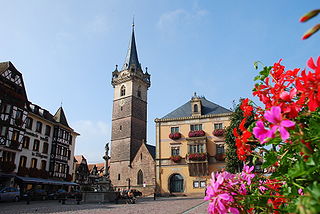
Obernai commune in the Bas-Rhin department in Alsace in north-eastern France. It lies on the eastern slopes of the Vosges mountains.

<span class="mw-page-title-main">Rosheim</span> Commune in Grand Est, France

Rosheim is a commune in the Bas-Rhin department in Grand Est in north-eastern France.

<span class="mw-page-title-main">Schirmeck</span> Commune in Grand Est, France

Schirmeck is a commune in the Bas-Rhin department in Grand Est in north-eastern France.

<span class="mw-page-title-main">Huttenheim</span> Commune in Grand Est, France

Huttenheim is a commune in the Bas-Rhin department in Grand Est in north-eastern France.

<span class="mw-page-title-main">Andlau</span> Commune in Grand Est, France

Andlau is a commune in the Bas-Rhin department in Alsace, Grand Est region of northeastern France.

<span class="mw-page-title-main">Avolsheim</span> Commune in Grand Est, France

Avolsheim is a commune in the Bas-Rhin department in the Grand Est region of north-eastern France.

<span class="mw-page-title-main">Barr, Bas-Rhin</span> Commune in Grand Est, France

Barr is a commune in the Bas-Rhin department in the Alsace region of north-eastern France.

<span class="mw-page-title-main">Goxwiller</span> Commune in Grand Est, France

Goxwiller is a commune in the Bas-Rhin department in Alsace in north-eastern France.

<span class="mw-page-title-main">Gertwiller</span> Commune in Grand Est, France

Gertwiller is a commune in the Bas-Rhin department in Alsace in north-eastern France.

<span class="mw-page-title-main">Innenheim</span> Commune in Grand Est, France

Innenheim is a commune in the Bas-Rhin department in Alsace in north-eastern France.

<span class="mw-page-title-main">Beinheim</span> Commune in Grand Est, France

Beinheim is a commune in the Bas-Rhin department in Grand Est in the Alsace region of northeastern France.

<span class="mw-page-title-main">Grendelbruch</span> Commune in Grand Est, France

Grendelbruch is a commune in the Bas-Rhin department in Grand Est in north-eastern France.

<span class="mw-page-title-main">Herrlisheim</span> Commune in Grand Est, France

Herrlisheim is a commune in the Bas-Rhin department in Grand Est in north-eastern France. The town dates from the 8th century. Herrlisheim was the scene of very heavy fighting during Operation Nordwind, an offensive launched by the German Army during World War II that inflicted considerable damage to the town.

<span class="mw-page-title-main">Le Hohwald</span> Commune in Grand Est, France

Le Hohwald is a commune in the Bas-Rhin department in Alsace in north-eastern France.

<span class="mw-page-title-main">Meistratzheim</span> Commune in Grand Est, France

Meistratzheim is a commune in the Bas-Rhin department in Grand Est in north-eastern France.

<span class="mw-page-title-main">Ottrott</span> Commune in Grand Est, France

Ottrott is a commune in the Bas-Rhin department in Grand Est in north-eastern France. It lies southwest of Strasbourg. The vineyards in and around Ottrott produce the red Rouge d'Ottrott, a geographical denomination within the registered designation of origin Alsace AOC.

References

  1. "Répertoire national des élus: les maires". data.gouv.fr, Plateforme ouverte des données publiques françaises (in French). 2 December 2020.
  2. "Populations légales 2019". The National Institute of Statistics and Economic Studies. 29 December 2021.
  3. INSEE commune file
  4. Population en historique depuis 1968, INSEE