Kurrah Dildarnagar Tajpur Usmanabad | |
---|---|
village | |
![]() Lawishely Green farms of Tajpur Kurrah village during Monsoon. | |
Nickname: Coconut village of the North India | |
Coordinates: 25°23′15″N83°41′17″E / 25.3876048°N 83.6880159°E | |
Country | ![]() |
State | Uttar Pradesh |
District | Ghazipur |
Established | 1570 |
Founded by | Zamindar Usman khan |
Government | |
• Body | Gram panchayat |
Area | |
• Total | 450.34 ha (1,112.81 acres) |
• Land | 440.025 ha (1,087.325 acres) |
• Water | 10.315 ha (25.489 acres) |
Population (2011) | |
• Total | 7,368 |
• Density | 1,600/km2 (4,200/sq mi) |
Languages | |
• Official | Hindi |
Time zone | UTC+5:30 (IST) |
Kurrah or Tajpur Kurrah is a village in Dildarnagar Kamsar region of Zamania tehsil in Ghazipur district. It is avillage of pathan Kamsaari pathans in the Indian state of Uttar Pradesh. Almost 3900 Kamsaar Pathans lived in the village as of 2011. [1] [2]
The Tajpur kurrah village was founded by Zamindar Usman khan a son of Narhar Khan founder of kamsar pathans and founder of Dildarnagar kamsar. Before Usman established this village his father Narhar Khan lived at a place in village name as Kamesardih. According to the old records of village it is said the village would be founded in late 1500 ADs. Later one of Usman's descendants shifted to Bihar and established Akhini village in Bihar state of India. On the banks of Karmanasa river. [3]
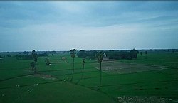
The village is situated at the banks of durgavati and karamnasa river and have good crop producing soil.
The Karamanasa river passes 3.2 kilometer from the village. The total area of the village is 1112 acres out of which the total crop production area of the village is 1000 acres. A variety of crops grow in Purvanchal and Bihar. The village has tractors, harvester etc. The village also have one Eidgah.
As of 2011 census, the main population of the village lives in an area of 111 acres with the total number of 976 house holds. [4]
Year | Pop. | ±% |
---|---|---|
1861 | 2,535 | — |
1871 | 2,788 | +10.0% |
1881 | 3,066 | +10.0% |
1891 | 3,374 | +10.0% |
1901 | 3,712 | +10.0% |
1911 | 4,082 | +10.0% |
1921 | 4,490 | +10.0% |
1931 | 4,940 | +10.0% |
1941 | 5,435 | +10.0% |
1951 | 5,434 | −0.0% |
1961 | 5,400 | −0.6% |
1971 | 5,940 | +10.0% |
1981 | 6,534 | +10.0% |
1991 | 7,100 | +8.7% |
2001 | 6,910 | −2.7% |
2011 | 7,316 | +5.9% |
Source:Census of India [5] [6] [7] |
Dr irshad khan Dr nawaz khan Dr tarannum khan Drx nusrat khan
Zamania is a town in the Indian state of Uttar Pradesh. Its municipal council is subordinate to the Ghazipur District. It is also the administrative head of Zamania tehsil,. It is also a very historical town, it derives its name from Ali Quli Khan Zaman, who was also known as Khan Zaman or Zaman Khan, he was a governor of Jaunpur, and Ghazipur during the time of Akbar.
Dildarnagar Kamsar is a pargana (region) and a mashra comprising 34 settlements located around the Karamnasa River in the Ghazipur district of Uttar Pradesh and the Kaimur district of Bihar, India. Of these, 18 mouzas are the primary settlements. It is a prominent settlement of Khanzadas, also known as Kamsari Pathans, as well as Afghan Pathans, primarily of the Niazi and Yusufzai clans. The original name of the region was Kamsar, but due to close and historical ties with the family of Bara Pathans, the region is often referred to as Kamsar-O-Bar. It was established in 1542 by Raja Narhar Khan.
Usia is a village in Kamsaar, Uttar Pradesh, India. It is located southeast of Ghazipur and east of Dildarnagar, near the Bihar State border. The village has a population of 24,786 residents living in 3,471 households. Usia is approximately 7 km from Dildarnagar. Around 8500 Kamsar Pathans lived here as of 2011.
Amir Chak is a village in Kamsaar in the Indian state of Uttar Pradesh.
Rakasaha is a village in Kamsaar in the Indian state of Uttar Pradesh. Almost 6500 Kamsaar Pathans(NAWABS) lived in the village as of 2011.
Gorasara is a village located in Dildarnagar Kamsar, Uttar Pradesh, India. Goarasara village was established by Bhikham Khan, son of Fateh Bahadur Khan, and great great grand son of Narhar Khan.
Saraila is a village in Kamsaar in the Indian state of Uttar Pradesh.Saraila is a village in Seorai Tehsil in Ghazipur District of Uttar Pradesh, India. It belongs to Varanasi Division. It is located 30 km to the south of District headquarters Ghazipur. 11 km from Seorai. 372 km from State capital Lucknow. The village was also a part of Daudpur Estate which had its capital at Dewaitha during Mughal and early British era.
Akhini, on the banks of the Karmanasa River, is a village of Kamsaar in the Indian state of Bihar. It is a bordering village of Kaimur district of Bihar. As of 2011 census the main population of the village lived in an area 72.5 acres and 741 house holds.
Bahuara is a village in Kamsaar in the Indian state of Uttar Pradesh. Bahuara is a village with a population of almost 5000. It is surrounded by others Kamsar villages. Bahuara is well connected with the town of Dildarnagar which is hardly 2-3 kilometres away from the village. People of Bahuara are scattered throughout the world. Ancestrally, the people of bahuara have been a land-owning (Zamindar) community divided into two colonies Westside & Eastside. Neighbouring villages are Rakhsaha, Dildarnagar, and others.
Bara is a village of Dildarnagar Kamsar in Ghazipur district in the Indian state of Uttar Pradesh. It is situated on the banks of the holy river Ganges.
Mania is a village in Kamsaar in the Indian state of Uttar Pradesh. It is located in Seorai Tehsil in the Ghazipur district. It is situated 22 km (14 mi) from the sub-district headquarters Seorai and from the district headquarters Ghazipur. Its total area is 428.68 hectares and a total population of 5736. Mania village was established in the early 1590 a.d. by Khizir Khan, who was a grandson of Narhar Khan.
Chitarkoni is a village in Kamsaar in the Indian state of Uttar Pradesh.
Khajuri Kamsar is a village in Dildarnagar Kamsar in the Indian state of Uttar Pradesh. Its situated on the bank of Karamsaha. As of 2011 census the main population of the village lived in an area of 44 acres with 531 households.
Jaburna is a village in Kamsaar in the Indian state of Uttar Pradesh.
Fufuao or Rampur Phuphuaon is a village in Dildarnagar Kamsar in the Indian state of Uttar Pradesh.
Seorai is a village of Dildarnagar Kamsar, and also serve as the headquarters of SeoraiTahsil in region of Ghazipur District of Uttar Pradesh, India. The Seorai tehsil was made a tehsil of the Ghazipur District in year 2016. It consists of 142 villages and one town. Seorai main village has a total area of 878.02 hectares and a population of 20000 but its total area is 1,082.83 hectares and a population of 20,530 which also includes Bhadaura. Seorai tehsil has the total area of 366.62 km2 (141.55 sq mi). Seorai also served as the capital of Kamsaar estate from late 1500s to mid 1600s.
Nawali is a village in Seorai tehsil of Ghazipur District, Uttar Pradesh, India.
Kamesarahdih is a hamlet of Dildarnagar Kamsar located in Ghazipur District of Uttar Pradesh, India. Kamesaradih is the main and a historical place of Dildarnagar Kamsar from where Kamsaar Pathans emerged and got their name Kamsaar. Kamesaradih have a kot which was built by Raja Narhar Khan in 1542s. The kot present in Kamesaradih is now under Archaeological Survey of India.
Dildarnagar is a municipality in Kamsaar of Ghazipur District, Uttar Pradesh, India. Dildarnagar is a fast-developing town. It is located 34 km from Ghazipur. It is also known as the heart of the Kamsaar-o-Bar region. The total area of Dildarnagar includes Fatehpur Bazar, Dildarnagar Gao, Tajpur, and Nirahukapura. These four neighbourhoods form the town of Dildarnagar. As of the 2011 census, the population of Dildarnagar was 28,913 and the town had an area of 1,995.95 hectares. Dildarnagar is on the road from Varanasi to Buxar. It was also the capital of Dildarnagar Estate.
Dewaitha is a village of Dildarnagar Kamsar,in Zamania tehsil of Ghazipur, India, located on the banks of the Karmanasa River and it's tributary Eknaiya, The village had a population of 7,104 as of the 2011 Census of India. The place is inhabited by Kamsar Pathans..